Litchi missions over mountains - use google earth or Litchi alone?

Joined
Aug 23, 2014
Messages
76
Reaction score
21
Website
www.stevenmichelsen.com
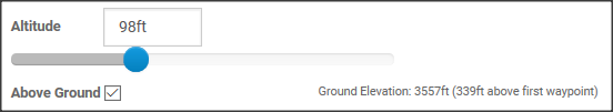
For some time now I have been using google earth to lay out Litchi missions that involve flying around mountains, or anywhere else that involves big changes in elevation. Now I see that Litchi has an "above ground" checkbox option that appears to do the same thing - set the height AGL based on the terrain, not the starting point. Here's that checkbox in the waypoint settings...
above_ground.png

This sounds great to me and makes things more convenient, but how well does it work? Does anyone have any experience with this to share? Can I trust the waypoints to be the proper height above the ground below? Thanks!
 
I use Litchi pretty much exclusively, but have not yet utilized the AGL feature. Just my own rule of thumb so to speak, I always add an additional 25 feet to any "Approximated" altitude, especially when mission planning. I would most likely do the same for the AGL feature. The reason I do this is due to the variations and the lack of precision of the AC Barometer. I have seen them off 30 feet before, and that number fluctuates. It is not exact by any stretch. Just 2 cents worth for you.
 
BTW here's the sort of mission I would like to switch to using Litchi AGL numbers. This one started out in google earth. Mission Hub - Litchi

Yes I am pretty sure I have line of sight the whole time. Will need it as I am doing manual control over heading and gimbal pitch.
 
Looked at your mission, post it if you run it, I don't really get the Litchi AGL numbers yet, I got my sequence that has been working, afraid to try new. :eek::rolleyes:

What is your bird?
16 mins on P3's makes me nervous.
Wind kind of messes up your battery time. ;)

Rod
 

Recent Posts

Members online

No members online now.

Forum statistics

Threads
143,086
Messages
1,467,525
Members
104,965
Latest member
cokersean20