I don’t know how many Litchi users are aware that it is now possible to set up a waypoint mission using the online Litchi Mission Hub site and export that mission as a Google Earth virtual video tour so you can simulate exactly what your DJI drone will record during flight. You will find some screen grabs of a recent mission that I set up below. (I tried to add the actual .kmz video file but couldn't.) The steps are as follows:
Happy flying!
- Using Chrome as your browser, go to the Chrome Web Store and download the Litchi Virtual Mission Extension HERE and have it added to Chrome.
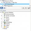
- Click on the 3 dots in the upper right of Chrome, then click on “More tools”, and then choose “Extensions”.
- Find the “Chrome Litchi Virtual Mission” extension and click on the Details button.
- Scroll down and click on “Extension options”.
- Choose your DJI drone model. This is important so what you see in the tour will closely represent what your specific camera lens will see.
- Establish a free account on the Litchi Mission Hub website if you haven’t already done so.
The above steps will only have to be set up one time. From here you are good to go.
- Use Chrome as your browser and create a waypoint mission in Mission Hub.
- Once you have the mission set up, you can save it by clicking on the blue “Missions” button in the lower left corner. You also have a NEW (red) option under that button “Export as VLM”. If you click on that, it will download a .kmz virtual tour to your Downloads folder. Double-click that file and Google Earth will open.
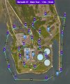
- Find the name of your waypoint mission under the Temporary Places folder and double-click on it. You will see a Virtual Mission listed under it. Double-click on that mission and it will run. (See attached example.)
Happy flying!