How to get higher altitudes than 500m?

Joined
Oct 10, 2016
Messages
8
Reaction score
3
Age
37
Hi,

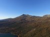
I often start my flights at sealevel, and want to go up to about 700-800 meters elevation to get a look at the top of the mountains.

I know that its not allowed to go higher than 120 meters above the ground, and that is not what i want either. I just wanna go from sealevel to around 700m in los, to look on top of the mountains , still at the legal elevation limit .

The 500m max elevation is very limiting here in Norway.
 
I want to look over this mountain. 700 meters high
 

Attachments

  • DJI_0007 3.JPG
    DJI_0007 3.JPG
    5.1 MB · Views: 1,125
Launch half way up the mountain.
You get 500 meters from the launch point.
Or maybe if you wrap your drone in foil it won't be able to get GPS.
 
Launch half way up the mountain.
You get 500 meters from the launch point.
Or maybe if you wrap your drone in foil it won't be able to get GPS.

Altitude is based on Barometric pressure change relative to take-off pressure, not GPS.
 
Launch half way up the mountain.
You get 500 meters from the launch point.
Or maybe if you wrap your drone in foil it won't be able to get GPS.

Yeah, i know thats one way to do it. But i wish it was possible to fly 120m/500m above the current position, not the takeoff point. It should be no problem for dji to use that feature, as the altitude can be calculated with very few sattelites (3, or 4)
 
Yeah, i know thats one way to do it. But i wish it was possible to fly 120m/500m above the current position, not the takeoff point. It should be no problem for dji to use that feature, as the altitude can be calculated with very few sattelites (3, or 4)

It doesn't use GPS for altitude.

It uses barometric pressure.
 
As a pilot of human carrying aircraft, I don't want to find a P3 at or above 1500 ft AGL..........:(

PS. I also fly a P3 and other RC aircraft.

As a pilot of human carrying aircraft, i doubt you fly only 120 meters above the hill tops? That is what i want to achieve. In other words, nothing worse than flying 120m over a football field.

I want to be able to follow the terrain, lets say 100 meters above the ground, up until 700m above sealevel , still not higher than 120m above the ground .
 
  • Like
Reactions: Peio64270
As a pilot of human carrying aircraft, i doubt you fly only 120 meters above the hill tops? That is what i want to achieve. In other words, nothing worse than flying 120m over a football field.

I want to be able to follow the terrain, lets say 100 meters above the ground, up until 700m above sealevel , still not higher than 120m above the ground .

120m is about 400 ft and yes, we do fly that low over hills/mountains on the odd occasion :)
 
Limits are maintained in the aircraft

Apps. will not bypass.
 
Thats a shame. I guess theres no way to buypass the 500m limit then.

What about the Litchi app?
I did read how to do this, I've never tested it myself and there is a small risk. You fly to lets say 450m and reset the home point there, at that location. Then go again to another 450m and do the same, and so on. But the risk as you might tell is if there's a RTH ?
 
I did read how to do this, I've never tested it myself and there is a small risk. You fly to lets say 450m and reset the home point there, at that location. Then go again to another 450m and do the same, and so on.
Resetting the home point would only reset the latitude and longitude location of the home point.
 
Resetting the home point would only reset the latitude and longitude location of the home point.
It was something I read in another thread where the same question was posted. So resetting the HP will not also reset the altitude at all ?
 

Members online

Forum statistics

Threads
143,066
Messages
1,467,356
Members
104,934
Latest member
jody.paugh@fullerandsons.