

- Joined
- May 21, 2013
- Messages
- 100
- Reaction score
- 16
John Shaw said:Koviatt - I am not sure what you meant by the photo in 3d.
I did my plot separately in Excel. I get my aerial views from Google Earth. I also worried about possible errors in bearing angle - true, magnetic etc. but I decided it didn't matter because when I overlay a picture of the polar plot on the picture from Google Earth and then stretch and align the plot overlay to match the locations at specific times as seen in your video it automatically takes care of scaling and rotation. I think the biggest error in my analysis is that it assumes you camera is looking straight down. If the camera is not looking straight down it introduces error.
Possible good news - if it is in the canopy as your now thinking it may have helped break the fall.
John,
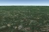
You know how you can place a pin in google earth and place it any distance above the ground, if you move all around you can see the pin floating around from different perfectives. I did this with a pin above the last known position and drew a line from it to the earth, Then I moved the view all around, zoomed in and out, etc - kind of scary to see how high it was above the terrain. AND to think I was another 400 meters above that at one time...grief. Feel like I will never ever see it again. Here is a snapshot of what I was talking about. Hard to tell - but the dot is 1200 meters above te last known location.
 :shock: :shock:

")


