Lost my whole new setup

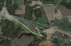
Headed back out there this afternoon to search the last large patch of woods. We have been thorough with all the fields. We KNOW it's out there somewhere and finger's crossed, these woods may hold the secret. And we have good video and lots of good advice from this forum.

I asked the question earlier but it may have slipped through the cracks. The Azimuth angle on the iOSD is not the actual position of the aircraft. Is there a reason for this? It is roughly 5-10 degrees off (number is high).
 

Attachments

  • last known position.jpg
    last known position.jpg
    130.1 KB · Views: 528
Navman said:
John, how were you able to get this info from his video?

John Shaw said:
I was able to find the location of the last pic on google earth. It was easier than I thought.
The photo a 13:16 of the video was taken at 36deg 9min 15.47secN 80deg 32min 39.2secW and was headed out Forbus Road. I put the red star at the site of the last pic and I expect it was headed SE.
I wish you luck in finding it. Hope this helps.

Approximate city and state were given.
I used the name on video and whitepages to find the address of the likely takeoff location.
I verified that objects at the start of the video matched objects in the Google Earth view of the takeoff location.
Distance and bearing info shows on the video and further narrowed it down.
Then I just looked on Google Earth to find an arrangement of fields and roads that match the latter frames.
Zoom in and look closer. etc. (It was made easier since the camera was pointed straight down.)
In my second post I used a snowier frame later in the video which was possible since I knew the location fairly closely and drew an x corner to corner over a copy of the frame to find the exact center.
That is also why the Google Earth shots I posted are not North Up as I rotated Google Earth to match the orientation of the last frames to enable easier pattern recognition.
This is a lot easier than you would think. And gets easier with practice.
 
Azimuth is the heading from your home location to the current position of the Phantom. Or is it the other way around? It's one of the two. If you start at your home location and plot a line 812m long on that heading that should give you the last known position. If it turns out to be the opposite direction (i.e. the course from the Phantom to home location) use the reciprocal by simply adding 180 degrees.
 
Pure Genius John, thanks for the lesson!

Think I'll have to print it out, good stuff to know since I don't work with google earth much!


John Shaw said:
Navman said:
John, how were you able to get this info from his video?

John Shaw said:
I was able to find the location of the last pic on google earth. It was easier than I thought.
The photo a 13:16 of the video was taken at 36deg 9min 15.47secN 80deg 32min 39.2secW and was headed out Forbus Road. I put the red star at the site of the last pic and I expect it was headed SE.
I wish you luck in finding it. Hope this helps.

Approximate city and state were given.
I used the name on video and whitepages to find the address of the likely takeoff location.
I verified that objects at the start of the video matched objects in the Google Earth view of the takeoff location.
Distance and bearing info shows on the video and further narrowed it down.
Then I just looked on Google Earth to find an arrangement of fields and roads that match the latter frames.
Zoom in and look closer. etc. (It was made easier since the camera was pointed straight down.)
In my second post I used a snowier frame later in the video which was possible since I knew the location fairly closely and drew an x corner to corner over a copy of the frame to find the exact center.
That is also why the Google Earth shots I posted are not North Up as I rotated Google Earth to match the orientation of the last frames to enable easier pattern recognition.
This is a lot easier than you would think. And gets easier with practice.
 
Elementary my dear watson


Awesome detective work :eek:
 

Attachments

  • Sherlock-Holmes-287x300.jpg
    Sherlock-Holmes-287x300.jpg
    15.9 KB · Views: 484
I think the limits were set very high - I know the altitude was.

I have given up the search. Another team of three searched methodically in the woods of the most likely area. And then expanded the search for a couple of hours. All told we have about 45 hours of ground and air time searching for this quad - its time to call it "lost." We poured over the search videos again zooming to look at anything that resembles a craft. Even went back to the field a couple times to verify uncertain objects.

Anyway, we are confident that we gave it our best shot - mostly because of all the help we got from your comments and advice. We took this guidance seriously.

I know it is still out there and not at the bottom of the ocean like some of you have experienced. That is very unsettling.

But it is just STUFF> so I am keeping that in perspective, right?

The wheat in all these fields will be harvested in a couple of weeks. We searched those pretty well by air and high def video, but it could be in there somewhere. Also there is a chance that the quad is stuck in the canopy somewhere. There is a LOT of cedars, kudzu, honeysuckle and other vines that overtake the woods and cover the tops of trees - virtually impenetrable, and difficult to examine from below. We did a few flyovers, but you know that hitting this stuff at 50 Mph or whatever speed would mean that it got down into the mess and is not visible from above. We looked anyway.

So, if nothing turns up in a few weeks, I will take another look around those woods in the winter after all the foliage is gone. By then I hope to already have replaced this beautiful craft with another p2.

If anything turns up I will let you all know. Again, thanks for all your help!! :)
 
You've done everything possible to find your machine, sorry it didn't end with a "found it" at the end

Did you by chance have phone number and "Reward if found" on it, maybe some farmer will still get it back to you.
 
I wouldn't post this during your time of mourning were it not for the fact that I *did* fly two into the ocean. A P1 in December, recovered worthless other than the memory card and spare plastic parts, and an P2 in January never seen again as I was practicing circular pans around a granite spire, and with low battery it apparently had no LOS for long enough to decide to land, in the ocean. Flew some S&R missions over the other side of the spire, and paddled out there more than once in the weeks that followed just in case I got lucky and spotted my lost lamb clinging to the rocks above the surf. Alas, no joy.

So, after two lost quads, also pure pilot error, I bought a Garmin GTU-10. Though clunky and expensive, I am VERY glad I did. Last week my P2 was half way home from a 4km distance run when NAZA suddenly decided to land. I rotated camera down, picked a good LZ, and the Garmin led me right to it in minutes. Whether its a Garmin or one of the other GPS trackers, I think it's worth the cost and weight. My only concern now is flying remote canyons where cell coverage is marginal, and I'm thinking about telemetry solutions to at least bring last known GPS coords back to the dash board, in the event I go down unexpectedly out of cell coverage.

I share your pain...

Kelly
 
Kelly, great advice. I had ordered three of the kickstart iPhone Tiles - Tiny GPS tracking devices ($20 each). Have you seen them? They just started shipping. Anyway, it sounds like you and I are a lot alike, Kelly. I told my son that I am a risk-taker - always have been. I love to push technology. I am building a quad right now with waypoint ability to fly long distance (okay, y'all, this flight will be will be supervised, okay? :eek: )

Anyway, I made several mistakes but have learned a lot on this flight. I fully intend to get another P2 if mine does not turn up. And the next one will have some kind of GPS tracker in it for sure.

Everything I own - planes, helis, radios, cases, batteries - has my name and number on it. I cannot believe that I did not ID my P2! Too much enthusiasm, I guess. But all the neighbors in a 20 mile radius are aware of the loss and will return it if found. We are a tight community. I let one farmer use the goggles, the other day while we flew my P1 searching for the P2 all over his property. We flew over his barns and silos. He was THRILLED. He is determined to find the missing P2 in his wheat fields. Ha!

My neighbor just texted me. Asked if we found the copter. I told him "No, and I am done." He said his family is going out to search for it this weekend. He asked for all my maps and all this forum's helps and suggestions. Talk about good neighbors.
 
I think the tiles are only Bluetooth based. Won't work for us out in the rural, longer distance environments. I think the TK102 and Garmin are your best bets, but google this site for GPS and you'll have hours of reading. The TAGG is another tracker folks are using.

My neighbors are two 70+ year old brothers with 33 acres of vines. One of them tried a cheap camera quad and gave up. I am planning to use Ground Station for them to fly a standard vineyard inspection route for them on a weekly basis. In my copious spare time... ;)

Kelly
 
Well...
Just for fun I made a polar plot of the bearing and distance that shows in the video and found the center of the frame on some key frames. I then aligned the plot to a google earth picture by matching the key spots on the polar plot to where the camera centered at that time using an overlay with GIMP (free graphics program). The red arrow is where forward was at the last useable frame but it had been changing heading constantly. The red dot is where the battery reported 0. It still had a long way to fall.

I had fun doing it. You are free use it or just get a laugh that I don't know when to quit.
 

Attachments

  • Polar.jpg
    Polar.jpg
    159 KB · Views: 538
John, I recently did a similar plot but did not publish it here. Yours is much more useful. Did you notice that the quad osd reading and it's actual position were off by about 6 degrees? This threw me off till I realized that - bottom line - the video was correct no matter what the compass said.

Is this photo in 3d overlaid on the map? Was trying to get a feel for the distance it might have traveled as it fell. As you could see in your data harvest, there initially were no appreciable winds until I got to over 1.2. It bounced around a little but held its position.

Thanks again for your work. I said I was done searching. But I went out yesterday and searched a couple more hours. We are thinking now that it may be stuck in the canopy rather than on the ground.
 
koviatt said:
We are thinking now that it may be stuck in the canopy rather than on the groung.

I suspect there is a fairly high % chance that that's were she sits.
 
Koviatt - I am not sure what you meant by the photo in 3d.
I did my plot separately in Excel. I get my aerial views from Google Earth. I also worried about possible errors in bearing angle - true, magnetic etc. but I decided it didn't matter because when I overlay a picture of the polar plot on the picture from Google Earth and then stretch and align the plot overlay to match the locations at specific times as seen in your video it automatically takes care of scaling and rotation. I think the biggest error in my analysis is that it assumes you camera is looking straight down. If the camera is not looking straight down it introduces error.

Possible good news - if it is in the canopy as your now thinking it may have helped break the fall.
 
A few things to consider.

I noticed that near the end of the video the Phantom was returning closer to its Home Point. I read you figured out which was the right direction and actively flew it in that direction.

Did you keep doing that after video was lost? If yes that would change the area where it might be as opposed to if you let go of the sticks.

Winds will NOT have been 'not appreciable' at 1200m. It only began to drift once wind speed got OVER its autonomous manoeuvring speed it uses for position hold. Below that point it was able to correct for wind speed but those speeds were certainly significant.

Once it started to drift it was pretty high up. When descending it will have moved through lower air layers where wind will have had different directions!!! than at the height where it began drifting. With increasing altitude (and thus increasing wind speed) wind direction changes clockwise in the Northern Hemisphere. The drift directions that were plotted higher up will not be the drift direction at lower altitudes. Direction will have shifted CCW with decreasing altitude.
 
Big Ben said:
A few things to consider.

I noticed that near the end of the video the Phantom was returning closer to its Home Point. I read you figured out which was the right direction and actively flew it in that direction.

Did you keep doing that after video was lost? If yes that would change the area where it might be as opposed to if you let go of the sticks.

Winds will NOT have been 'not appreciable' at 1200m. It only began to drift once wind speed got OVER its autonomous manoeuvring speed it uses for position hold. Below that point it was able to correct for wind speed but those speeds were certainly significant.

Once it started to drift it was pretty high up. When descending it will have moved through lower air layers where wind will have had different directions!!! than at the height where it began drifting. With increasing altitude (and thus increasing wind speed) wind direction changes clockwise in the Northern Hemisphere. The drift directions that were plotted higher up will not be the drift direction at lower altitudes. Direction will have shifted CCW with decreasing altitude.

Yes I kept "pushing" the copter home even after I lost video. Eventually I gave up. I heard the motors pulsing and walked over to look around some trees. Kept expecting to hear the crash...but never did. Obviously it was too far away from me to hear that. But I was shocked that I could hear the motors at all at that distance.

The last known video showed it at 7 m/s headed home. We all suspect that most of the 1200 meters was a freefall. With negligible wind from that point down it should have fallen into the areas that have been identified in this thread.

I spoke with another neighbor today. He has some fields outside the search area. He is going to keep an eye out when he harvests his wheat. I showed him a picture of my Phantom 1 to give him an idea of what he should see. He said, "that thing would make a nice wide opening in the wheat and should be easy to spot." Hope he is right.

You don't' know how many times I have almost placed an order for a whole new set up. HA.. I loved that copter....have been pricing new and used setups...I am leery of buying used, from someone I don't know...maybe I should look at these classifieds...
 

Members online

Forum statistics

Threads
143,085
Messages
1,467,522
Members
104,961
Latest member
Dragonslair