Lost my whole new setup

Joined
May 21, 2013
Messages
100
Reaction score
16
$1500 + lost - I am sick.

I had flown this new set up with the HeroPro 3+ and all the trimmings, zemuse, Mini iOSD, and a 600 mw FPV set up. Fantastic set up - my favorite of a large collection of quads, including a P1 and many helis and planes. This set up was by far the nicest thing I have flown.

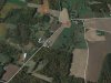
I had tested the set up to 1 km. No problems. Then decided to push the copter to 1.6 km My personal goal - one mile above my home. I live in the country and only sparse homes around. Mostly farmland and woods.

I will post a video if anyone thinks they can help me evaluate what might have happened.

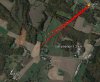
Best I can tell, the high winds at that altitude pushed me a little off course. 800 meters - but still kept a video link - keep in mind I maintained radio and video contact throughout - well over 5500 feet - pretty amazing.

I lost video contact when the battery dropped to 8.8 volts. That is probably when the whole thing shut off. I could hear the motors surging off in the distance - at that time I was 700 meters from home and over 3500 feet high. Amazing that I could hear the motors surging like that.

We did a quick study of the local video - then headed out for a search.

It was not a DJI flyaway, it was pilot error. Had I paid closer attention to my location I would have kept it closer to my home position and it would have mode it home with battery to spare. I was at 45% when I headed back home. So I am confident of this fact.. Then video was breaking up some during this drift and it distracted me from keeping things under control. I did not realize why it was doing this until I discovered that I had drifted so badly. Once I got the patch receiving antenna back in line I knew I was in trouble.

Well, we have spent hours flying the other phantom quad all over about 100 acres of woods and waist-high wheat fields. No luck. We have studied the videos...gone back to look at suspect areas...grief.

Does anyone know what the descent rate of a free-falling Phantom 2 is? at 3500 feet no power and possible slight wind, I am trying to localize the landing point. I need HELP!!!!

Kent

Here is the whole video:

http://youtu.be/4qkZlJ-fl1k

Thanks everyone.
 
1600m up at a max decent rate of 2m/s should have been able to get you down in about 8-9min, but you would have needed to start bringing her down much earlier than you did (~45% mark). Sorry for your loss.
 
Thanks for the insight. I did not realize that 2 m/s was the max descent rate. If I did the math right, that would be more like 13 minutes. Wow. So seriously, 2 m/s is the limit? I switched in and out of GPS and ATTN a couple of times trying to "increase" the controls.
 
Sorry for your lost.
I watched the video and noticed a few things, not sure how useful they're for locating your quad but hopefully will reduce the chance of us losing the next one in a similar fashion.

Too much wind:
It looks like there was a lot of wind and the quad was having a hard time holding position in GPS mode. In fact, it is almost using all available horizontal thrust to try and stay in one place. You can tell by looking at the OSD pitch and roll angle indicator. In GPS mode, the max tilt is 25 degree (combined vector). In your case, it is at 20-21 degree just holding still, so that means that it is near the limit of the ability to maintain station in GPS mode, you'll make very little headway against the wind if you have to and FS mode would not work as it has a even lower pitch limit.

At the start of the flight, I usually lift the quad to maybe 50-60ft (above the nearest obstacles) and have it face directly into the wind on GPS mode with all stick centered to observed the pitch angle as it holds position. It gives you a clue on hold hard the quad have to work to fight the wind. If the pitch is >12 degree (50% power) then I would only ever fly it upwind just in case.

Note that the max pitch in a bit higher in ATTI mode (35 degree) but lower in FS mode is even lower at around 15 degrees, so you'll have to be very careful with that.

Descend is too slow:
With firmware V3.02 and up, the max descend rate is 2m/s in GPS/ATTI mode. So your flight is at risk even before you finished your ascend to 1.6km altitude as it would take like 13-14 min just to come down at 2m/s. Your option at that point is either go to manual mode which doesn't have descent limits, or if your TX is not so configured, do a CSC to shut down the motors, let it free fall to maybe 300 meters or so then restart and hope it stabilizes. The later option is risky, but we've seen videos of a NAZA controlled quad doing such and in your situation the alternative would certainly be worse.

Where did it fell?
As to where it would have fell after you lost video contact... I am not expert at this area but it would likely depend on what you were doing with the sticks for the next 15-30 seconds. The battery probably still have some power to not completely free fall even if it cannot maintain altitude for a little bit even after the video fails. So if they are on, it can possibly drift quite a bit. I would search downwind from the last known location.

Here is my estimates:
Estimated wind: 12m/s, based on the fact that it takes 20 degree pitch to hold position
Freefall speed (terminal velocity): 25m/s (golf ball is 32m/s and P2 has lot more to catch the air like props and stuff)
Semi-powered uncontrolled descend at: 10m/s for maybe 20 seconds more before total freefall
Last known altitude: 1200m

This would mean it will fall for about 60 seconds, putting it about 800m downwind from last known location based on our very rough estimation.
 
Re: Lost my whole new setup - Where IS it NOW?

You guys are amazing. Cannot tell you how comforting it is to have this community. I have been reading posts in this forum since it started (a few years ago) and have done very little posting. Anyway, I appreciate the insights.

I tossed and turned through the night wondering how I could have done such a dumb thing - especially not doing the math. I guess I was counting on the same descent rate as my climb rate. After all, 50% power up - 45 % left to get her back. What's the big deal?? Doofus. Oh well.

So I will factor in the numbers that you guys have posted here and look father down wind.

On the subject of wind, yes air was DEAD calm at the ground. I flew across the road to get more open space and a visual. No wind - at least I thought...had I known how to "test for winds aloft" like you suggested, I would have known that I would have needed to abort.

One more thing that confused me. The artificial horizon seems backwards to me. I know that negative pitch means nose down - and I was flying (as you saw on the video) with -20 degrees pitch, but the "cursor" was indicating above the line? Can you guys explain that?
 
damoncooper said:
1600m up at a max decent rate of 2m/s should have been able to get you down in about 8-9min, but you would have needed to start bringing her down much earlier than you did (~45% mark). Sorry for your loss.

Or in cases like these, flip to manual mode and bring her down at 15+ m/sec. I do this all the time.

Sent from my Nexus 7 using Tapatalk
 
golgotha said:
damoncooper said:
1600m up at a max decent rate of 2m/s should have been able to get you down in about 8-9min, but you would have needed to start bringing her down much earlier than you did (~45% mark). Sorry for your loss.

Or in cases like these, flip to manual mode and bring her down at 15+ m/sec. I do this all the time.

Do you have any video? What's the technique? I'd like to learn to do this. How hard is it to recover from manual mode fall at 15m/s? Does it put any extra stress on the props or airframe?
 
Post by Kelso Kubat » Sun May 25, 2014 3:11 pm

i saw a lot of static :shock:
------------------------------------------------------------------------
Yes I saw it too! :lol:

But I was trying to get to the bragging rights of one mile. Made it, but now only have the static low-res video to prove it. Ha.

ko
 
golgotha said:
damoncooper said:
1600m up at a max decent rate of 2m/s should have been able to get you down in about 8-9min, but you would have needed to start bringing her down much earlier than you did (~45% mark). Sorry for your loss.

Or in cases like these, flip to manual mode and bring her down at 15+ m/sec. I do this all the time.

Sent from my Nexus 7 using Tapatalk

Like Ian, I too would like to master the Jedi Descent. Please elaborate.

Kelly
 
macheung said:
Sorry for your lost.
I watched the video and noticed a few things, not sure how useful they're for locating your quad but hopefully will reduce the chance of us losing the next one in a similar fashion.

Too much wind:
It looks like there was a lot of wind and the quad was having a hard time holding position in GPS mode. In fact, it is almost using all available horizontal thrust to try and stay in one place. You can tell by looking at the OSD pitch and roll angle indicator. In GPS mode, the max tilt is 25 degree (combined vector). In your case, it is at 20-21 degree just holding still, so that means that it is near the limit of the ability to maintain station in GPS mode, you'll make very little headway against the wind if you have to and FS mode would not work as it has a even lower pitch limit.

At the start of the flight, I usually lift the quad to maybe 50-60ft (above the nearest obstacles) and have it face directly into the wind on GPS mode with all stick centered to observed the pitch angle as it holds position. It gives you a clue on hold hard the quad have to work to fight the wind. If the pitch is >12 degree (50% power) then I would only ever fly it upwind just in case.

Note that the max pitch in a bit higher in ATTI mode (35 degree) but lower in FS mode is even lower at around 15 degrees, so you'll have to be very careful with that.

Descend is too slow:
With firmware V3.02 and up, the max descend rate is 2m/s in GPS/ATTI mode. So your flight is at risk even before you finished your ascend to 1.6km altitude as it would take like 13-14 min just to come down at 2m/s. Your option at that point is either go to manual mode which doesn't have descent limits, or if your TX is not so configured, do a CSC to shut down the motors, let it free fall to maybe 300 meters or so then restart and hope it stabilizes. The later option is risky, but we've seen videos of a NAZA controlled quad doing such and in your situation the alternative would certainly be worse.

Where did it fell?
As to where it would have fell after you lost video contact... I am not expert at this area but it would likely depend on what you were doing with the sticks for the next 15-30 seconds. The battery probably still have some power to not completely free fall even if it cannot maintain altitude for a little bit even after the video fails. So if they are on, it can possibly drift quite a bit. I would search downwind from the last known location.

Here is my estimates:
Estimated wind: 12m/s, based on the fact that it takes 20 degree pitch to hold position
Freefall speed (terminal velocity): 25m/s (golf ball is 32m/s and P2 has lot more to catch the air like props and stuff)
Semi-powered uncontrolled descend at: 10m/s for maybe 20 seconds more before total freefall
Last known altitude: 1200m

This would mean it will fall for about 60 seconds, putting it about 800m downwind from last known location based on our very rough estimation.

macheung

I really appreciate this information. Question: your description and assessment puts the quad nearly a mile from its original location. I can see this, no problem. But what I am wondering about - as it descended from 1200 meters (4000 feet) I eventually could HEAR its motors pulsing. I kept straining to hear it crashing through the tree canopy (never heard it, of course). If it had blown away to that distance it is even possible to hear the pulsing that far away? I know I am asking you to look into a crystal ball to answer this question, sorry about that. But maybe putting all the pieces of the puzzle together will help me find my equipment.
 
Do you have a satellite (google earth) screen shot of the area it was over from the approx height when it lost signal? It was hard to tell from the video because of the static. If your camera was facing straight down during the decent it wont be that hard to get an approx location. If the camera was not facing straight down it is still possible just not as easy. Get a screen shot of where you were standing when you could hear it and the wind direction and lets see if we can find it!
 
Yes, I think Google Earth would be a big help. There is a lot of detail visible near the useful end of the video. If you compare a last frame to google earth you should be able to determine where the last video frame was taken. If I knew your lat long at take off or approximate location (some near by street etc) I would be willing to take a look for a match.
 
I was able to find the location of the last pic on google earth. It was easier than I thought.
The photo a 13:16 of the video was taken at 36deg 9min 15.47secN 80deg 32min 39.2secW and was headed out Forbus Road. I put the red star at the site of the last pic and I expect it was headed SE.
I wish you luck in finding it. Hope this helps.
 

Attachments

  • lastpic.jpg
    lastpic.jpg
    134.3 KB · Views: 595
John Shaw said:
I was able to find the location of the last pic on google earth. It was easier than I thought.
The photo a 13:16 of the video was taken at 36deg 9min 15.47secN 80deg 32min 39.2secW and was headed out Forbus Road. I put the red star at the site of the last pic and I expect it was headed SE.
I wish you luck in finding it. Hope this helps.

My son and I searched just north west of your star. The camera is pointing directly down as you can tell by some of the last good video frames. Tomorrow we will search in the area around your star. I measured the distance from your star to my launch - 3500 feet. We will search along both sides of the road. Flying the FPV phantom 1 will make that job much easier. I will keep you all posted on our progress.

Your interest and help has been very encouraging. I was ready to throw in the towel.
 
Where was your launch spot in reference to the red star on the map? I have found that I can only hear them for about 600-700 meters.
 
0% Battery at an altitude of 1.2km is never a good sign. Had any luck with the search yet?
 
My flight data on the map. That is all drift from winds. So assuming the winds continue....where would you look? Dentedk may be pretty close? The reason for the swing back to home is because I finally figured out my home position and pushed it back in that direction just before I lost battery. ALSO, to give you a reference, the distance between the furthest point from home and my last position is 260 meters (860 feet).
 

Attachments

  • lost phantom.jpg
    lost phantom.jpg
    439.1 KB · Views: 622

Recent Posts

Members online

No members online now.

Forum statistics

Threads
143,086
Messages
1,467,525
Members
104,965
Latest member
cokersean20