- Joined
- Aug 1, 2015
- Messages
- 1,754
- Reaction score
- 520
- Age
- 40


So both KML files have equivalent height, though it appears that the HealthyDrones accounts for HP elevation (somehow?). My guess then is the debate irt the crash into the trees or into something above the trees is a matter of visual perspective. Can you run the HealthyDrones KML through Google Earth and screen shot it w/ the same perspective as the one you did? I have a feeling they are going to be equivalent.
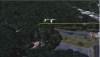
That first image is the LAUNCH point.Both paths overlapped, same perspective
View attachment 36053
And the entire flight overlapped
View attachment 36054
There are some dicrepencies, but I would bet thats only because one KML is a LOT bigger than the other, leading to more guesses for the healthydrones file
I can see that. There;s a lot more minute variances in the djilogs file.What I think we have learned so far is that healthydrones is NOT a good source for KML conversion!
Yeah, I wonder why he truncates the data? It's clearly all there in the original file. This leaves Google tasked w/ extrapolating between points. I guess he wasn't intending these KML files to be used in crash forensics. Good to know regardless, and thanks for your help Streve.What I think we have learned so far is that healthydrones is NOT a good source for KML conversion!
Correct. Check the dashware video and what the drone at the bottom does at the crash point.
I can see that. There;s a lot more minute variances in the djilogs file.
I just want to be sure however, we're still pretty sure this was a crash due to hitting something, and not because the drone operated improperly (causing the crash), correct?
Ever hear of a Nigt Owl? They hunt Phantom's at night, Yummy!It was night. Maybe a bat?
We use essential cookies to make this site work, and optional cookies to enhance your experience.