

You are using an out of date browser. It may not display this or other websites correctly.
You should upgrade or use an alternative browser.
You should upgrade or use an alternative browser.
Litchi Mission Lost Phantom
- Thread starter DaveD
- Start date
Should have clarified my post. I was referring to the choice of words in the subject title. Nothing within any of your posts suggests you are personally blaming the app.I am absolutely not saying the app is responsible for my lost phantom. I was using Litchi when it happened thats all. I have found the correct file and uploading it now.

Please log on to Litchi Hub on your computer. Click missions in the lower left. Click open and then find the mission. One of the tabs/folders to the right of the mission me will allow you to share it. Paste that here.This is the mission. Phantom Log Viewer - PhantomHelp.com
when the homepoint updates like that, is there a way to tell where? Or is it updated to that point on the yellow line?
Mission Hub - LitchiPlease log on to Litchi Hub on your computer. Click missions in the lower left. Click open and then find the mission. One of the tabs/folders to the right of the mission me will allow you to share it. Paste that here.
Check last WP. Your drone is probably there
Sent from my SHIELD Tablet K1 using PhantomPilots mobile app
That would be my backyard. Definitely not there. Thanks though.Check last WP. Your drone is probably there
Sent from my SHIELD Tablet K1 using PhantomPilots mobile app
Neon it was a scosh over a quarter mile away at 150 feet happily cruising along at 30MPH with plenty of gas, What happened? I mean I suppose that is where the record suddenly ends because of loss of signal to the Remote? The data we have, shows a happy bird doing what it was told, and then vanishing into thin air. I'm gonna call Mulder.

What Never, his brother is playing a joke on him, or he had a waypoint somewhere he did not plan to?Check last WP. Your drone is probably there
Sent from my SHIELD Tablet K1 using PhantomPilots mobile app
You definitely hit a tree. At takeoff, your elevation was 268ft ASL(above sea level). Your Phantom rose to 154ft above that point, so 422ft ASL. You have it programmed to stay at 154ft the entire mission. That does NOT account for ground level elevation changes. At waypoint 2 the elevation has risen to 303ft ASL (35ft gain) so your bird is now 119ft above the surface below and at waypoint 3 the ground elevation has risen to 418 ft ASL, exactly 150 ft above the first waypoint and 4ft above the ground. Using your mission that you posted and adding several waypoint between the original 2 and 3 you can see that the ground is rising just as you cross the road entering the forrest. I am almost certain your bird is in the woods around the NEW waypoint 5 as I show in my picture.
Attachments
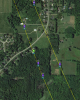
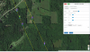
You didn't account for the surface elevation gain and flew straight into the woods. When you plan these missions you need to add 150ft to the elevation at each waypoint in order to stay 150ft above the surface. When you plan your mission on the computer(vs the app) the elevation difference will be displayed everytime you drop a new waypoint. See the box for the NEW waypoint 5 I set and notice the ground elevation reading below Altitude.
Attachments
I am fripping impressed Jiggy...er ..Mr. Jiggy B. I had looked at the flight earlier and it looked like flat open ground to me. VERY Nice detective work. I have to learn to do that. Wow.You definitely hit a tree. At takeoff, your elevation was 268ft ASL(above sea level). Your Phantom rose to 154ft above that point, so 422ft ASL. You have it programmed to stay at 154ft the entire mission. That does NOT account for ground level elevation changes. At waypoint 2 the elevation has risen to 303ft ASL (35ft gain) so your bird is now 119ft above the surface below and at waypoint 3 the ground elevation has risen to 418 ft ASL, exactly 150 ft above the first waypoint and 4ft above the ground. Using your mission that you posted and adding several waypoint between the original 2 and 3 you can see that the ground is rising just as you cross the road entering the forrest. I am almost certain your bird is in the woods around the NEW waypoint 5 as I show in my picture.
That's a bummer....what a simple error.
I'm watching this with great interest as to whether or not the OP finds his bird now
I'm watching this with great interest as to whether or not the OP finds his bird now
The ground elevation at the first patch of trees is 86 ft above your starting waypoint. That means if any of those trees are 154-86=78ft tall, it could have hit one of those and could be there. I don't have the time now but if you just overlay the log you have from Healthy Drones and line it up with your mission, you should be able to see where it lays. If it hasn't rained there, chances are you have a totally salvageable P3S.
RodPad
Premium Pilot
The ground elevation at the first patch of trees is 86 ft above your starting waypoint. That means if any of those trees are 154-86=78ft tall, it could have hit one of those and could be there. I don't have the time now but if you just overlay the log you have from Healthy Drones and line it up with your mission, you should be able to see where it lays. If it hasn't rained there, chances are you have a totally salvageable P3S.
Im on my way!

Rod you are so right. This is what makes PhantomPilots what it is. I don't mind, and actually enjoy, helping some new owner understand the technicalities of his/her new toy, but this sh** is where it is at. Sharp guys.I like this stuff, Now were getting somewhere!
Rod
Ok. I am also impressed. So I am ready to go back out in the woods in the morning. Where should I start looking? I am still a little confused as to how I can read actual elevation at these points. Help me understand please.
Someone may get to it first, but I'll check back in a little while and I think I can pinpoint it. Before this thread gets too far along though, the real lesson here as it pertains to Litchi, is to add 100's of ft to your missions and review them later and learn and make adjustments. There is a pretty good sized learning curve associated and a mathematical mind certainly helps. You set your waypoints way too far apart. You can't see all of the elevation changes. You can plan your mission the way you did, then go back and use the "insert" function. That adds a waypoint exactly between the previous and next points taking on an average of their values. In other words point 1 is heading 90 at 100ft and waypoint 2 is heading 110 at 200 ft. Using the "insert" button (while point 1 is active) a NEW point 2 will be added halfway with heading 100 at 150ft and so on if you halve it again. Each point after that will be assigned the next number. ie the existing 2 becomes 3 and 3 becomes 4 etc. I'll check back later.
I think the steep price drop in these Phantoms has and will lead to a ton more of these stories. When I paid $800 for my P3S I was paranoid to throw it up in the sky. Now they cost a fraction of that and I think demand a fraction of the respect.
I think the steep price drop in these Phantoms has and will lead to a ton more of these stories. When I paid $800 for my P3S I was paranoid to throw it up in the sky. Now they cost a fraction of that and I think demand a fraction of the respect.
Last edited:
- Joined
- Aug 15, 2016
- Messages
- 3,591
- Reaction score
- 1,540
- Age
- 45
Never give up mate. These guys helped me locate my lost drone a few months back. Your in safe hands here [emoji4][emoji4]
Neon Euc
Neon Euc
Similar threads
- Replies
- 6
- Views
- 5K
- Replies
- 6
- Views
- 6K
- Replies
- 27
- Views
- 52K
- Replies
- 5
- Views
- 3K


Recent Posts
-
-
-
 North Jersey, Very new old guy trying to get off the ground with a P330Z Phantom 2
- Latest: captainmilehigh
-

-
