I looked at the flight record and video. Here's what I see and my take on it.
0 - 5:26 All was well. You went straight up from the parking lot
5:26 Link lost for 6 seconds & Auto Land initiated. Altitude decreases from 979' My guess is that since it was overhead, you kept the R/C level. When flying high directly over, pull back so that the antenna are more horizontal..
6:27 Auto Land cancelled. Altitude is low/mid 500ish feet
6:62 Altitude starts decreasing from 543'
7:15 GPS lost - Atti Mode - 239' high, Altitudes lowers to 200' then starts steady rise. No change of horizontal position from Home.
8:09 Log ends with bird at 468 ft.
It's odd that you went from 19 to 0 satellites. You had both USA GPS and Russia GLOSASS signals as AFIAK it's not possible to have that many birds of only one type. You may be able to convince DJI to replace the P4 saying the GPS failed totally in flight.
Video:
:00 Starting AutoLand?
:17 Video freeze.
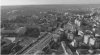
:22 P4 is straight above Home launch point of hotel parking lot
:23 GPS lost ???, hiccup in video ( Atti Mode???)
:24 You fly over the Ramada hotel (Atti Mode ??)
:35 Look to the top left. See the smoke direction from the smoke stack. That's the wind direction and your drift. East and a bit South is my read.
:47 You yaw to the left, over shoot the Hotel by about 90 deg. You're drifting downwind East, slightly South
:49 You are trying to control it back to you (Atti Mode?)
:54 Video feed lost
1:04 Video recovered. Same apparent altitude as at :54, Drifting downwind.
1:08 Video lost. Most likely blocked by the Hotel.
Presuming it did an AutoLand my guess is to look east of the KFC (65C & E79) up to 500M and maybe a tad north and then a lot south by the 65. But .. by now someone has found it or it's in a spot where no one can see it or some one's back yard where they eventually will find it. Maybe post some flyers?