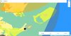
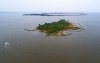
I flew my drone in the coast and tried to take some photo of a small island. It is only about 300m direct distance from home point, and about 3500m to a military NFZ (see the figure in red square, blue is military NFZ). Drone was taken off smoothly with GPS level about 14. I started to fly to the small island with altitude about 110m in P mode. Before the drone reached to center of the island, all GPS signal suddenly lost. The compass was abnormal and IMU abnormal. The drone switched to ATTI Mode, RTH function disabled. The drone floated within 8miles/h wind and flew far and far. The battery level was about 85%.
I was a little bit panic, but fortunately I trained myself how to fly with ATTI Mode, I found out the orientation and so I can enter the correct stick commands to offset the drift from the wind. After struggle for about 8 minutes, I pulled the drone back to the home point safely. During the way home, the RC didn’t gain any GPS, and still showed compass error and IMU error. After I came back to home, I re-calibrate all.
What I learned are:
1. Training yourself with ATTI Mode until you can control the drone smoothly with 5-10 miles per hour wind;
2. Do not panic, and find correct stick commands, then controlling the drone becomes easy;
3. Nerve try to fly 5 miles near NFZ.
4. Do not fly drone over a big bridge (I flew my drone and took photos over a key bridge and an overpass, and lost GPS signal. I flew back in ATTI Mode too).