I appreciate the insight into RTH. I see I need to train with RTH so I understand what it will do when I need to rely on it. In level terrain I was only using RTH as a last resort backup, I like the idea of setting RTH to terrain plus 400'. I adhere to the 400'altitude limit especially in that remote uncontrolled area because occasionally Seahawk helicopters come through the canyons hot and low, I can see the pilot. Not a problem when I'm under control when I hear them, I drop to below 200'. But if the P3s is under automated RTH control I am uncomfortable with a terrain plus RTH altitude of1200' if only for a couple minutes.
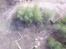
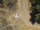
I found an old homestead possibly dating back to the 1800s, with no visible land access beside a rugged hike in. So I'm trying to fully explore the site by air,. One out building possibly a barn is downslope on the opposite side of the mountain. If I drop down for a closer look I will most likely lose control signal. In another site, I think BLM land about a mile to the south I found what I think is an air marker. I don't know if its a research marker, immigrant direction sign or narco drop site. I want to explore that closer but dropping down again would likely put me in RTH control and the only chance to save the P3s if the control signal is lost. Thanks for the help Ill test and train so I can rely on RTH when needed.


")


