Hum, well not that this is going to help him find it, I was kind of waiting a while before I threw this out there.
Could the OP downloaded the mission from the HUB to his mobile, then accidentally tapped on his mobile and created a new way point (I have done it more than once).
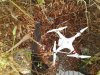
The time I didn't notice it, It flew the mission and I was ready to hand catch it when it was auto landing, part of the mission. Suddenly it took of at full speed to the East, hit a tree then the ground.
I walkover picked it up and carried back to the garage, the app was singing to me Warning Disconnected, so I shut everything off, The extra waypoint was now non existence, because the mission never got re-saved to the hub.

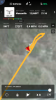
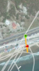
It wasn't until I was reviewing the original mission and the flight log that I decided what had happen, when I was satisfied I reran the saved mission from the hub. This was a mission I had reused many times before.
")
Just a thought.
Rod


")


