Litchi Hub BUG

Joined
Jul 8, 2017
Messages
149
Reaction score
58
Age
63
Location
Las Vegas, NV
I have just posted this on the official Litchi Facebook group. Hopefully they'll approve it so others will see it. :mad:
---
There is a bug in Litchi Hub that caused my Phantom 3 Pro to crash. I do not make this statement lightly. I have flown close to 200 Litchi missions without incident so I am not new to the software or the Hub. The bug is easy to reproduce.

Here are the steps:

1. Login to Litchi Hub and create a new mission
2. Add your first waypoint
3. Set your Altitude value (I used 164 feet)
4. Click on Above Ground and close the waypoint window
5. Add a second waypoint and close the waypoint window

After this step, you'll notice Litchi has already included the altitude information from the first waypoint and has checked the Above Ground checkbox. The second waypoint will include your above ground altitude in yellow and the actual altitude in parentheses. This is what should happen.

6. Click on Waypoint #1. This will open the waypoint window.
7. Click on Insert in the upper left and close the waypoint window

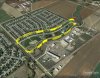
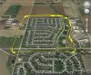
The inserted waypoint will now be labeled as Waypoint #2 but it will NOT have the altitude information set or the Above Ground checkbox checked. This is easy to miss because you expect the behavior to be consistent. I have included a screenshot from the fatal mission I ran yesterday. It has a total of 54 waypoints and 22 POIs. (only a few are in the picture) Unfortunately, the first one I missed caused my P3P to crash into a high ridgeline. I was concerned that I might run into a bug after the numerous changes made a few months ago.

This needs to be fixed.

LitchiWaypointBug.JPG
 
Hi VegasFlyer

Real sorry for your loss, I just did what you said in the order you said it and sure enough the inserted waypoint which appeared after waypoint 1 did not have the above ground check box ticked.

I agree with you, it is to a degree, intuitive that an "Inserted" waypoint created within the menu would mirror the first waypoint created, because that is what happens when you click on the map to create the next point, but as you sadly found out, with software intuition is not necessarily your best friend.

Given the scenario you had, 54 waypoints, I might have missed it, but when I did my test I only created 3 waypoints, and in fairness to you I saw the problem immediately.

Sorry for your loss my friend I will now be much more careful using Mission Hub.

Waylander
 
  • Like
Reactions: VegasFlyer
Hi VF

Just tried to look at your problem again, and it's weird, you might be aware of this, but some OP's may not.

At a location I know well I created my first waypoint at altitude 10 meters ( 10 m UK metric ) with above "ground checked" next clicked on the map at a point about 80 m away which showed in yellow 10 m and in brackets ( 15.1 m) and a third another 90 m away which showed 10 m ( 24.8 m).

All well and good, so I erased them and started again, first at 10 m ( 10 m) and the next one 170 meters away which indicated 10 m ( 24.8 m), then as you did I returned to point 1 clicked on it and when the box opened I clicked the insert button, this inserted a waypoint 85 m from the first ( half way between the two ) and showed a height of 17.4 m so this equates to exactly half way between the first and the second and also at a height ( 17.4 m ) which was exactly half of the difference between the first and the second waypoints original heights.

So now I have three waypoints Clicking and moving the 1st point causes the heights to change as you would expect, and so for the point at 24.8 m, so far what you would expect, but dragging the waypoint in the middle ( 17.4 m) did not cause the height to change, so if I drag that point up to the highest marker ( at 24.8 m) and dropped it there it retained it's original altitude of 17.4 m. So if I had not know of this problem I would have flow into the ground three quarters of the way up the hill.

So friends when using "above Ground " altitudes in Litchi make sure you see two altitude references, 1 in yellow and 1 in () brackets at every waypoint to avoid this problem.

Waylander
 
  • Like
Reactions: VegasFlyer
I always export and view the mission in Google earth before ever flying it for real. I agree this appears to be a bug but Litchi is complex and quite easy to introduce 'finger trouble' when using the mission hub. Would this have saved the bird in your case?
 
  • Like
Reactions: VegasFlyer
Hi VF

Just tried to look at your problem again, and it's weird, you might be aware of this, but some OP's may not.

Waylander

Here is Litchi's response:

"Litchi Hello,

I am sorry to hear about your crash.
This behavior is actually intended and not a bug. Litchi will apply the settings of the last added waypoint to a newly inserted waypoint, but when inserting we chose not to apply these as in most cases it wouldn't make sense to apply the last added waypoint's settings to a waypoint that is potentially inserted in the middle of the mission."

My reply:

With all due respect, this decision makes NO sense. As you can see on the graphic, I'm decsending from 1164 feet at waypoint 41 to 814 feet at waypoint 43. Had waypoint 42 behaved like all the others, we would not be having this discussion.

I went back to the Mission Hub and dropped a POI at waypoint 42 (see attached graphic) and the height displayed is 1081 feet which is 92 feet higher than what is displayed on the waypoint. Why would you even think someone would want different settings when inserting a new waypoint? That, too, makes no sense. How can you say "Litchi will apply the settings of the last added waypoint to a newly inserted waypoint" when that is clearly wrong?

I posted this on phantompilots.com and a gentleman in England came up with the same result using altitudes of less than 25 meters. His comment was "So if I had not known of this problem I would have flown into the ground three quarters of the way up the hill." How can you say this isn't a problem?

I've been in the computer industry since the late 80s and I know that only the "show stopper" bugs are addressed prior to a new release. However, this requires a fix. Whoever made the decision to let this behavior stand needs to rethink the consequences. Your software isn't free and these drones are not cheap!

LitchiWaypointBug01.JPG
 
I always export and view the mission in Google earth before ever flying it for real. I agree this appears to be a bug but Litchi is complex and quite easy to introduce 'finger trouble' when using the mission hub. Would this have saved the bird in your case?

No, it wouldn't have made a difference. I, too, use Google Earth but I create the mission there first, export it as a .KML file, and then import it into the Hub where I finalize the route. It's really the same process but it requires one less step. I had flown this mission before and all went well. It was after I tweaked it by changing a few POIs and adding 2 additional waypoints that the mishap occurred.

EDIT: I add my above ground altitude in GE and that information comes over just fine.
 
Last edited:
I always export and view the mission in Google earth before ever flying it for real. I agree this appears to be a bug but Litchi is complex and quite easy to introduce 'finger trouble' when using the mission hub. Would this have saved the bird in your case?

There are a couple of reasons for creating missions in Google Earth first.

1. You can view the area in 3D which you cannot do in Litchi Hub. Just make sure to check the Terrain box under the layers list on the bottom left.
2. It's the method recommended by Laurence Seberini, who runs the Phantom Filmschool
 
Sucks man,
Is this a total loss?

I haven't tried your test yet. Every time I have looked at the above ground option I get confused and shut it off and do it my old way. :eek: ;)

Rod
 
Sucks man,
Is this a total loss?

I haven't tried your test yet. Every time I have looked at the above ground option I get confused and shut it off and do it my old way. :eek: ;)

Rod

I received a phone call the very next night by a hiker who said he'd found a drone. (my phone number is taped to the bottom) I was stunned considering the terrain. The guy was hiking above where the drone crashed and he spotted it on his way down. He gave me his address and I went over to meet him. If that wasn't lucky enough, the only damage to the drone was to one prop that lost 3/4 of an inch off the tip and there's a hairline crack on the battery case. (The battery had popped out upon impact. I always give it a really hard tug before flight) That's it! There isn't a single scratch on the body and zero damage to the gimbal. I fired it up at home and everything works! Absolutely amazing! The last entry in the log shows it was at 1060 feet. I'm unable to go hiking so there's no way I would have found it. This is where the drone went down: Drone Crash

I'm still PO'd at Litchi. If you insert a waypoint, wouldn't you want/expect it to have the same parameters as the waypoints that bracket it? It's silly that they refuse to use the same above ground altitude and tick the Above Ground checkbox automatically which is what happens if you add a new waypoint.

The Above Ground option is extremely useful. I've always used this in GE. Before the Hub changes earlier this year, all altitudes in GE were imported as absolute values instead of relative to ground. Using Above Ground does away with having to worry about any increase/decrease in the height of the terrain below the drone. For example, in the attachment I'm using 150 feet with the Above Ground option checked. In this mission I'm flying above relatively flat land. But if I should encounter a hill, the drone will remain 150 feet above it. Now, if I forget to tick the check box next to Above Ground, the drone will fly at a constant height of 150 feet and that can spell disaster!
AboveGround.JPG
 
  • Like
Reactions: RodPad
Hi VegasFlyer

Well that's great news on the drone find, I hope you bought the Hiker a beer....!

I like Litchi, especially it's friendliness with Google Earth when regarding waypoint mission imports created in GE, I also use the Autoflight Autopilot app, for a paid app @ $30.00 for the basic version, it is not so user friendly, when you import a KLM file from Google Earth, AutoPilot disregards the " Relative to Ground" altitude set in Google Earth and makes every waypoint altitude a default height which is set in the Autopilot app, and there is nothing like Litchi mission hub form setting up missions. I don't know why I still bother to use it....:(

Anyway... congrats on the safe return of your drone.

More happy Flying then... Ha ha

Waylander
 
  • Like
Reactions: VegasFlyer
Hey that's great!, way luckier than I. :rolleyes:

I did take a few minutes yesterday, starting to get idea of how this new de-feature works :eek: ;).

Rod
 
  • Like
Reactions: VegasFlyer
Here is Litchi's response:

"Litchi Hello,

I am sorry to hear about your crash.
This behavior is actually intended and not a bug. Litchi will apply the settings of the last added waypoint to a newly inserted waypoint, but when inserting we chose not to apply these as in most cases it wouldn't make sense to apply the last added waypoint's settings to a waypoint that is potentially inserted in the middle of the mission."

My reply:

With all due respect, this decision makes NO sense. As you can see on the graphic, I'm decsending from 1164 feet at waypoint 41 to 814 feet at waypoint 43. Had waypoint 42 behaved like all the others, we would not be having this discussion.

I went back to the Mission Hub and dropped a POI at waypoint 42 (see attached graphic) and the height displayed is 1081 feet which is 92 feet higher than what is displayed on the waypoint. Why would you even think someone would want different settings when inserting a new waypoint? That, too, makes no sense. How can you say "Litchi will apply the settings of the last added waypoint to a newly inserted waypoint" when that is clearly wrong?

I posted this on phantompilots.com and a gentleman in England came up with the same result using altitudes of less than 25 meters. His comment was "So if I had not known of this problem I would have flown into the ground three quarters of the way up the hill." How can you say this isn't a problem?

I've been in the computer industry since the late 80s and I know that only the "show stopper" bugs are addressed prior to a new release. However, this requires a fix. Whoever made the decision to let this behavior stand needs to rethink the consequences. Your software isn't free and these drones are not cheap!

View attachment 98876
Congrats on the recovery of the aircraft with minimal damage. She lives to fly again! If I am reading Litchi's response correctly, I understand why they don't copy the last added waypoint settings onto a newly inserted waypoint. Apparently, there is only one last added waypoint variable, and the last added waypoint would likely be at the end of your mission or somewhere very different, not the nearest waypoint next to a newly inserted waypoint. They would need to add new programming to copy inserted waypoint settings from the nearest waypoint, not the last added waypoint. Clearly, however, it is in unintentional trap for the unwary. Thanks for sharing it with us, so we won't make the same mistake, too! P.S. Finally bought a new Win 10 Pro machine based upon your previous advice and suggestions. Thanks for the help! Works like a champ on PP CC at 5x the speed of my 4 year old Win 7 Pro machine! :cool:
 
Another "feature bug"??

As I'm fairly new to flying drones (private pilot for 50 years) and a newly certified remote pilot, I am definitely new to Litchi and Mission Hub. I am so grateful to learn of this unintentional "feature" when inserting a new waypoint, and was grieving your DJI P3P loss through each continuing post. I have my FAA Drone registration # on the top of my P3P and I'm adding my phone number on the bottom of my P3P!

I have discovered another weird quirk when using the Litchi App (it may also occur in Mission Hub - I haven't confirmed it yet). I first created a 12 waypoint mission with a few POI's in the Litchi app, just to fly a perimeter around a small park nearby, and saved the mission.

Next, I wanted to modify this saved mission by extending waypoints on three sides of the roughly rectangular perimeter flight path. To do this I load the saved mission, made my waypoint positional changes, checked my changes then saved the modified mission under a new name.

Then, through this forum, I learned about sync'ing missions between the Litchi App and Mission Hub, exporting a mission to a KML file and viewing in Google Earth! Great, wonderful. When I loaded the KML file into Google Earth I saw the new, expanded and modified perimeter of flight but it also showed the original, smaller perimeter of flight as well (and flight altitudes above ground were all precise and correct).

I exported the modified mission to CSV and opened it in Excel, only to find that the only waypoints listed were that of the expanded perimeter flight path. This must be a "feature" that someone has run across before.

Any ideas?

Thanks
 

Attachments

  • ParkMission.jpg
    ParkMission.jpg
    878.4 KB · Views: 133
  • ParkMissionModified.jpg
    ParkMissionModified.jpg
    817.9 KB · Views: 132

Recent Posts

Members online

No members online now.

Forum statistics

Threads
143,094
Messages
1,467,600
Members
104,980
Latest member
ozmtl