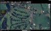
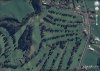
cshaw Joined Apr 28, 2014 Messages 69 Reaction score 20 Age 67 Location New Plymouth, New Zealand Sep 16, 2014 #1 What maps does the ground station software use? I see different aerials in Google maps in the PC Ground station and in the DJI app Attachments WGC_DJI App.jpg 47.5 KB · Views: 284 wgc_GS_PC.jpg 165.4 KB · Views: 347 wgc.jpg 66.7 KB · Views: 394
What maps does the ground station software use? I see different aerials in Google maps in the PC Ground station and in the DJI app