

- Joined
- Nov 2, 2017
- Messages
- 2
- Reaction score
- 0
- Age
- 41
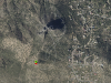
My Dad and I are both drone enthusiast and last weekend, the unthinkable happened to my poor pops, he flew around a mountain (more like a rock outcropping), lost signal. These things happen he thought... but he waited and waited until it was certain the RTH had failed. He thinks his return altitude was set too low to raise above the rocks... beings that my dad is in his 60's and crushed by the loss of his most prized possession I figured I would put in the leg work look here for some help... all the information I have from him so far is that it was at "Thumb Butte" in Prescott AZ and a picture from is flight log but I am unsure how to plot any waypoints as all I have from him is this picture. Any and all suggestions welcome!
Thanks in advance,
Brance
Thanks in advance,
Brance
")


