- Joined
- Mar 5, 2019
- Messages
- 425
- Reaction score
- 460
- Age
- 68
- Location
- Florida’s Most Overpriced Hometown
I will do my best to answer any questions you have on charts. They are fairly easy for me and once you learn the information in the Legend they are quite easy to read. You still have to check apps like Aloft to make finding things like NSUFR’s easier.Thank you, this is the best description I have I seen thus far. I opened Skyvector and saw something I had never heard of before, DROTOMS. I did not realize the FAA was putting out NOTOMS specific to drones. Learning sectional maps is my goal, thus my questions.
A trick on using SkyVector is to use the World VFR to locate the area. Then if you need to access the Legend, switch to the local VFR sectional like New Orleans, Jacksonville, Miami, etc. The Legend will always start in the top left of the local sectional.
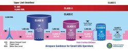
Class B - solid blue line
Class C - solid magenta line
Class D - dashed blue line
Class E - dashed magenta line
These are areas that will require LAANC approval.
If you have a local flight school check with them to see if they have any out of date paper sectional maps they would sell you for cheap or free. Once out of date they cannot be used on a flight, but they make a great learning tool.
Last edited: