Shoot4fun
Drone bum...
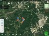
sar104,
A little better pic. The fields to the right I KNOW are off limits. The smaller one to the right, according to dji geofence, is inside the no fly zone as well. I tried the northern most point as well as southern most. Wouldn't even spin a prop. More of a curiosity than anything. According to your first image I should be able to fly the field to the left, but I can't. Tried a few weeks ago looking for a fender that had come off one of our Spray rigs. Again, it's more a curiosity than anything. All these different maps showing different no fly zones, and dji getting too obnoxious with their geofence.
A little better pic. The fields to the right I KNOW are off limits. The smaller one to the right, according to dji geofence, is inside the no fly zone as well. I tried the northern most point as well as southern most. Wouldn't even spin a prop. More of a curiosity than anything. According to your first image I should be able to fly the field to the left, but I can't. Tried a few weeks ago looking for a fender that had come off one of our Spray rigs. Again, it's more a curiosity than anything. All these different maps showing different no fly zones, and dji getting too obnoxious with their geofence.