Potential National Parks loophole?

Joined
Jun 21, 2022
Messages
3
Reaction score
2
Age
30
I’m going to be visiting Acadia National Park, so I’ve been doing some digging to try and find some areas around/outside the park where I can legally fly my drone.

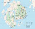
During my research, I came across the Acadia National Park map provided by the NPS.

It might be a stretch— but going by the legend, it appears to me that the areas highlighted in green specifically define Acadia National Park, meaning that areas which are not highlighted in green are technically not part of the park?

If this is the case, then we could assume that take off/landing should technically be permitted within these areas, could we not?
 

Attachments

  • FB5AE32C-80B1-4D32-892C-B62367D12C4A.jpeg
    FB5AE32C-80B1-4D32-892C-B62367D12C4A.jpeg
    547 KB · Views: 172
This isn't a loophole, it's how the rules are written. If you can launch and operate from outside their boundaries, and maintain FAA regs (VLOS being the most limiting), you are allowed to fly over the parks. Make sure there aren't any wildlife restrictions in place though. Nesting season will create temporary closures.
 
This isn't a loophole, it's how the rules are written. If you can launch and operate from outside their boundaries, and maintain FAA regs (VLOS being the most limiting), you are allowed to fly over the parks. Make sure there aren't any wildlife restrictions in place though. Nesting season will create temporary closures.
So would you say that you believe the areas highlighted in brown instead of green are indeed outside of the boundaries, meaning that it would be safe to fly from those locations?
 
As someone who creates maps as part of my job, according to the official map legend, only the green areas are part of Arcadia National Park. This, however, doesn't necessarily give you the green light to launch from anywhere outside of the green. Most-likely, any land that is not green on the map will be private property with posted No Trespassing" signs. And, as mossphotography points out, the second the trees block your view of the drone as it flies out over the forest, you will be flying illegally. Hardly worth the effort, unless flying straight up to 400' and taking a photo of the nice sunset/sunrise over the park.
 
best to have national park's own maps when determining true borders, IMO;
Everglades National Park is bisected by US 41 "Tamiami Trail";
map shows east half of that public road to have JUST a narrow north shoulder
ribbon that is NOT part of national park for 30+ miles -- verified with head ranger few years ago;
& I have taken off & landed on it several times -- but not on Miccosukee Reservation land;
whereas a further north bisecting highway I-75 "Alligator Alley is show as being wholly
part of national park;

what I'd like to hear from authoritative sources that are NOT national park employees
is whether a public highway & its shoulders can, in fact be national park ground...?!?!?!

(putting aside the FAA issue of flying nearly directly above passing traffic...)
 

Recent Posts

Members online

No members online now.

Forum statistics

Threads
143,086
Messages
1,467,527
Members
104,965
Latest member
Fimaj