My ground markers

Joined
Jan 15, 2018
Messages
19
Reaction score
10
Age
61
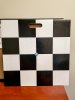
I thought I would share the ground markers we fabricated at my company. See photos. These markers are made of 24" x 24" x .25" plexiglass. We glued four (4) 12" x 12" checkered vinyl squares ( https://www.amazon.com/gp/product/B004GF5492/ref=oh_aui_detailpage_o01_s00?ie=UTF8&psc=1) to each marker. We then mounted a screw hook in the middle of each marker and cut a hole in each for carrying purposes. Four (4) small rubber legs were mounted to each marker to give clearance from the screw hook nut on the underside. We use these markers to confirm scale. I suppose one could use these for temporary ground control points (as long as they are not moved.). The purpose of the screw hook is so a single person can run a tape measure from one marker to another without assistance from another person. We have about $40.00 in materials wrapped up in each marker. Plywood could be used to reduce costs, but we decided on plexiglass for it's weather-proofing characteristics.
 

Attachments

  • m1-1.jpg
    m1-1.jpg
    543.8 KB · Views: 594
  • m2-2.jpg
    m2-2.jpg
    632.4 KB · Views: 503
  • m3-3.jpg
    m3-3.jpg
    990.2 KB · Views: 526
Last edited:
OK.......nice job.....nice pictures too.......Now how are they used....with the Drone is it for Real Estate and to show footage..from the air ect.
 
I work in the environmental consulting and engineering business and we use drones to collect imagery for 2D orthomosaic maps, topographic maps, 3D surface models and for determining volumetric calculations (soil cuts, fills, stockpile volumes). We also use DroneDeploy flight software and their cloud-based mapping software. The ground markers are used to confirm the relative accuracy of our 2D orthomosaic maps. We usually space the markers 50 ft. apart. If we need high absolute accuracy, as in most of our topographic maps we produce, we use ground control point (GCPs). Though these markers can also be used for GCPs.
 
Last edited:
I work in the environmental consulting and engineering business and we use drones to collect imagery for 2D orthomosaic maps, topographic maps, 3D surface modeling and for determining volumetric calculations. We use DroneDeploy flight software and their cloud-based mapping software. The ground markers are used to confirm the relative accuracy of our 2D orthomosaic maps. We usually space the markers 50 ft. apart. If we need high absolute accuracy, as in most of our topographic maps we produce, we use ground control point (GCPs). Though these markers can also be used for GCPs.

All of that is intriguing. I wish I could get into that type of work.
 
Thank You sooooooooooooo much for the explaining of the nicely made "ground Markers".......i appreciate your reply Thanks.
 
All of that is intriguing. I wish I could get into that type of work.

Our core business is the investigation and remediation of contaminated soil and groundwater. Not knowing your background, most people in environmental consulting/engineering firms have college degrees in environmental science, environmental engineering, chemical engineering, civil engineering, chemistry, geology or hydrogeology.
 
  • Like
Reactions: FlyAlongside

Recent Posts

Members online

Forum statistics

Threads
143,109
Messages
1,467,706
Members
104,999
Latest member
intertronixlabel