We will check this accordingly.Channel selection does not hold, if you press channel 32 close settings , come back and it's on channel 1, why ?


You are using an out of date browser. It may not display this or other websites correctly.
You should upgrade or use an alternative browser.
You should upgrade or use an alternative browser.
Mission Planner (FPV Camera – iOS Waypoints App) Available Now
- Thread starter PVFlyer
- Start date
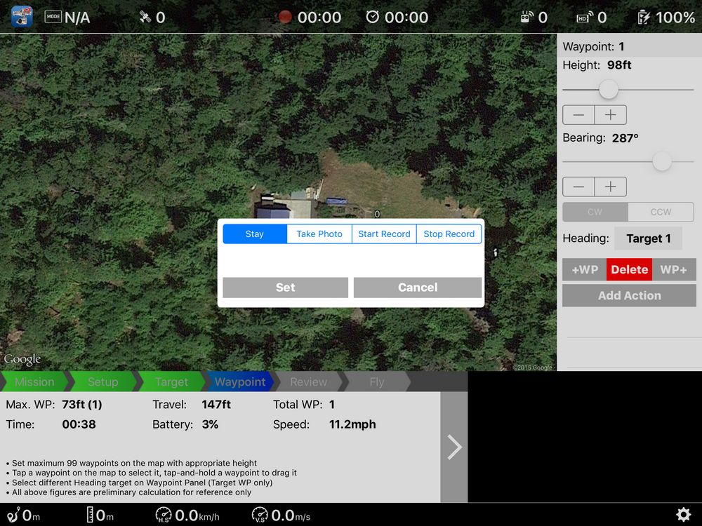
We will improve this as DJI just fixed the SDK bug as mentioned earlier.When I am at this dialog box for a waypoint, I found you can add an action, say "stay", and press the "set" button. Then you can select "add action" and add another action, like "take photo", and again press the "set" button. Both actions are then saved for that waypoint. By the way, when you select another new waypoint location, I believe the actions are copied into the new waypoint. I have not found a specific time identified for the "stay action", but I am willing to bet PVFlyer might enhance the actions available or expand on the ones currently available if enough people ask. I wonder if this where the "panorama" action might go? Hmmmm...
- Joined
- Sep 20, 2015
- Messages
- 15
- Reaction score
- 0
- Age
- 69
I was not being critical of you or the app, merely reiterating the steps that I take when listing an action or multiple actions for a waypoint. Just wanted to make sure I had it correct and add to the thread to address Fast13's question which I believe used the word "wait" instead of "stay".We will improve this as DJI just fixed the SDK bug as mentioned earlier.
I understand you are working to improve this and other areas and are limited by the SDK.
Am I correct that this is where a "panorama" action would go?
We will improve this as DJI just fixed the SDK bug as mentioned earlier.
After watching this folder re Mission Planner and liking what I saw, I purchased your app on the "monthly subscription" plan. (have yet to fly a mission)
Question:
When PVFlyer has done several updates/upgrades, how will I know when and how to download these improvements?
- Joined
- Sep 20, 2015
- Messages
- 15
- Reaction score
- 0
- Age
- 69
After watching this folder re Mission Planner and liking what I saw, I purchased your app on the "monthly subscription" plan. (have yet to fly a mission)
Question:
When PVFlyer has done several updates/upgrades, how will I know when and how to download these improvements?
PVFlyer has been pretty conscientious about posting notifications here and I, because I use the iOS based app, learn of available updates through iTunes.
The latest posting of steps to take before flying "mission planner" is very useful.
The app only cache Google Map, and the map caching is handle by Google Map itself.
The mission files store WPs and other configuration without any mapping data. Map is mainly used for planning stage. When you open a mission on-site, you can fly it even without map at all, as long as WPs are processed properly in the app.
So all map layer caching is handled by Google Maps.
Is there any benefit to having the Google Map App installed or will maps be cached even if it is not installed? I already had it installed before installing FPV Camera and my map layers were available off line. Would they have been available offline had Google Map not been installed?
I figured a mission would work without map layers just like Go. But, cached map layers are nice.
Sometime in the future, it would be a nice improvement if the App was able to store map layers to ensure they existed in the field without internet. This would involve a lot of storage space on the device, but could be an option for the user if they have the space. This would be a professional level improvement.
Flew the first mission today. I made some intial mistakes eg set initial height to RTH height instead of 1st waypoint.Suggest to adjust the procedure a bit.
3. Kill DJI app in Camera View WITHOUT going back to main page.
4. Open Mission Planner app.
5. Open saved mission.
6. Take off and hover at least 5m height.
7. Switch to F mode.
Had a few issues, whiloe flying I noticed it was not recording video although I set it to auto record in settings.
Also when it reached the last waypoint it wanted to land immediately even though I set it to RTH. I took control and flew it back to land on my landing board by switching to P mode.
Flew the same mission again immediately after landing and checking auto record was selected. It took off again but did not start video recording. I pressed the video record button on th RC and it started recording showing elapsed time but no red indicator on. If set to auto record when motors are first started should it start recording when taking off?
Again when it reached last waypoint it started to auto land with a bright red flashing sign saying autoland! Again I switched to P mode and flew it back.
Questions.
What does standard mean in initial height dialogue?
If you set a homepoint before going to the flying area how do you get it to reset the homepoint to where you actually are ie there was a discrepancy from where I marked the intial homepoint when at my home to where I did my calibration and initial startup in DJI App.
Why didnt it return to homepoint after reaching waypoint 6 the last one?
I tried to adjust the gimble tilt as flying but it would only allow me a few degrees of tilt, it would be handy to be able to use the full tilt angle.
Finally how does the height of the target effect the gimble tilt? I set mine targets to 0 but it didnt seem to point down enough although the targets were some distance away.
Does the height of target refer to height relevent to initial starting height of the machine or some other reference?
It flew the mission smoothly and panned smoothly from one target to another.
Sorry for so many questions, just want to get full control.
Actually, this is my error. My maximum height as set in the DJI Go app was 120 meters. Once I increased this my missions fly without complaining about the aircraft being to high.The message is directly from DJI SDK. This is probably due to the takeoff point is too close to the first WP with a high altitude. Either set it farther or lower altitude should fix it.
Oh great! And than you for not pointing out my error that the term is "stay" vs "wait". You got what I meant. Much appreciated.There is a bug in DJI SDK to ignore the Stay action. DJI fixed this issue in the latest SDK 2.4.1, and we have also fixed it in the app and the fix will be available in the next update. We plan to add a wait duration and update the document as well.
Yup. My bad.I see the parameter "Stay", not 'Wait". Is that what you are referring to?
When a new update available, Apple's App Store would notify you. If you accept notification for the app, we usually send you notification about new update available.After watching this folder re Mission Planner and liking what I saw, I purchased your app on the "monthly subscription" plan. (have yet to fly a mission)
Question:
When PVFlyer has done several updates/upgrades, how will I know when and how to download these improvements?

Panorama is likely a new mission type (like Waypoint or Target WP) instead of WP action.I was not being critical of you or the app, merely reiterating the steps that I take when listing an action or multiple actions for a waypoint. Just wanted to make sure I had it correct and add to the thread to address Fast13's question which I believe used the word "wait" instead of "stay".
I understand you are working to improve this and other areas and are limited by the SDK.
Am I correct that this is where a "panorama" action would go?
- Joined
- Sep 20, 2015
- Messages
- 15
- Reaction score
- 0
- Age
- 69
Panorama is likely a new mission type (like Waypoint or Target WP) instead of WP action.
Acknowledged, thank you for the update.
I have been using mission planner for a couple of days and it is working as planned.
I have it set to start record automatically and it does so.
I have not tried straight mode, stop and take a snapshot, continue.
My question is if I tell it to take a snapshot will it stop recording video, take a snapshot, and start recording again.
Or do I have to add all these commands manually.
I have it set to start record automatically and it does so.
I have not tried straight mode, stop and take a snapshot, continue.
My question is if I tell it to take a snapshot will it stop recording video, take a snapshot, and start recording again.
Or do I have to add all these commands manually.
FPV Camera uses Google Map SDK for mapping within the app. There is no benefit having Google Map app installed, while these 2 apps are independent.So all map layer caching is handled by Google Maps.
Is there any benefit to having the Google Map App installed or will maps be cached even if it is not installed? I already had it installed before installing FPV Camera and my map layers were available off line. Would they have been available offline had Google Map not been installed?
I figured a mission would work without map layers just like Go. But, cached map layers are nice.
Sometime in the future, it would be a nice improvement if the App was able to store map layers to ensure they existed in the field without internet. This would involve a lot of storage space on the device, but could be an option for the user if they have the space. This would be a professional level improvement.
FPV Camera uses Google Map SDK for mapping within the app. There is no benefit having Google Map app installed, while these 2 apps are independent.
ok, thanks!
Auto Recording sometimes couldn't start after opening the app second time. We have fixed the issue and will be available in the next update.Flew the first mission today. I made some intial mistakes eg set initial height to RTH height instead of 1st waypoint.
Had a few issues, whiloe flying I noticed it was not recording video although I set it to auto record in settings.
Also when it reached the last waypoint it wanted to land immediately even though I set it to RTH. I took control and flew it back to land on my landing board by switching to P mode.
Flew the same mission again immediately after landing and checking auto record was selected. It took off again but did not start video recording. I pressed the video record button on th RC and it started recording showing elapsed time but no red indicator on. If set to auto record when motors are first started should it start recording when taking off?
I thought you probably set the last WP within 20m from home point, and aircraft would land instead of ascending to RTH altitude then RTH. This is a normal behavior even using DJI app.Again when it reached last waypoint it started to auto land with a bright red flashing sign saying autoland! Again I switched to P mode and flew it back.
Check the Setup tab for Initial Height. It's worth to spend 30 minutes to read the entire document in Help.What does standard mean in initial height dialogue?
Once you have connected aircraft, home point will be updated. Read the Setup as mentioned earlier.If you set a homepoint before going to the flying area how do you get it to reset the homepoint to where you actually are ie there was a discrepancy from where I marked the intial homepoint when at my home to where I did my calibration and initial startup in DJI App.
If you want full gimbal control, you may turn off Auto-Tilt and control the tilting manually.Why didnt it return to homepoint after reaching waypoint 6 the last one?
I tried to adjust the gimble tilt as flying but it would only allow me a few degrees of tilt, it would be handy to be able to use the full tilt angle.
If you set target height = 0, then the target is treated on the ground. All height values are relevant to home point.Finally how does the height of the target effect the gimble tilt? I set mine targets to 0 but it didnt seem to point down enough although the targets were some distance away.
Does the height of target refer to height relevent to initial starting height of the machine or some other reference?
Auto Recording sometimes couldn't start after opening the app second time. We have fixed the issue and will be available in the next update.
I thought you probably set the last WP within 20m from home point, and aircraft would land instead of ascending to RTH altitude then RTH. This is a normal behavior even using DJI app.
Check the Setup tab for Initial Height. It's worth to spend 30 minutes to read the entire document in Help.
Once you have connected aircraft, home point will be updated. Read the Setup as mentioned earlier.
If you want full gimbal control, you may turn off Auto-Tilt and control the tilting manually.
If you set target height = 0, then the target is treated on the ground. All height values are relevant to home point.
Thank you for your patience in answering my questions.
Well I ended up purchasing the app while the sale was on, so thanks for that. I did like it during beta testing and it seems to work well. Now to do some more complex flights.
Alan
Alan
- Joined
- Nov 14, 2013
- Messages
- 49
- Reaction score
- 0
I bought the app and mission planner the other day. I am trying to figure out how to load the map of my flying area from home. I fly at a park some 40 km away and would like to load up a mission here at home before I leave as I will not have an internet connection at the park. How do I easily get a map of the area I want to fly in from my home without having to scroll through kilometres of map until I hopefully find the park I want?
Similar threads
- Replies
- 6
- Views
- 4K
- Replies
- 0
- Views
- 2K
- Replies
- 16
- Views
- 4K
- Replies
- 1
- Views
- 9K


