

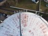
Appologies if my screenshot has mislead the viewers. Its purpose was not to show where did you lost radio contact, but just to let you point where exactly you found the battery. In the mean time @sar104 has lead me to the revealing message #11.
This screenshot is a better attempt.
I still don't understand why you say you cannot eventually see the drone on the tower roof by flying with the Mavic over it ? Ok it's white foreground on white background but you may fly right over the tower and point the camera 90* to the ground. Above the tower you are safe from the microwave radiation that is beamed by the cell communication dishes.
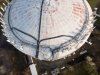


")


