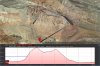
My home is about 2250 feet above sea level and I routinely take off at altitudes of 2700+. I've flown waypoint missions taking off at around 2720 feet with an above ground clearance of 165 feet without a problem. Yesterday I went to a scenic spot that had a take off altitude of 3850 feet and Litchi gave me "Takeoff Altitude Too High" error. I checked the maximum altitude setting and it was at 500m (1640 feet). My maximum mission altitude was to be 4865 feet (the height of the peak is 4700 feet) and Google Earth shows an elevation gain of 1239 feet. (see map) This shouldn't be a problem. I had no problem flying manually up to 730 feet AGL at that location. I've taken my P3P up to 1300 feet AGL manually (4220 feet above sea level). I know the P3P uses barometric pressure but there should be no difference between manual and autonomous flight. In my opinion this is a bug in Litchi. The maximum altitude setting will allow you to enter values of at least 600m but I haven't tried taking off with this setting.
Thoughts on this issue?
BTW, the route you see below is entirely legal regardless of the altitude.
Thoughts on this issue?
BTW, the route you see below is entirely legal regardless of the altitude.