I pay no attention to B4UFLY. I am 7 miles from PHL and they have me as inside the zone.B4UFly. Way off.
Said I was inside the 5 mile flight circle.
Called tower gave them my location and was informed I was 4.5 miles outside the flight zone.
Sent from my LG-D850 using Tapatalk


You are using an out of date browser. It may not display this or other websites correctly.
You should upgrade or use an alternative browser.
You should upgrade or use an alternative browser.
Go app reports restricted area but Airmap and B4UFLY do not
- Thread starter Raptorman0909
- Start date
Something has been up with AirMap the last few days. It's showing anything within the 5-mile radius of any airport as a "flight strictly regulated" area vs "advisory" area. Definitely some kind of error.
I'm just confused by their designations. Under "Commercial", Airmap appears to show the Class G airspace under the 700 ft Class E airspace around untowered airports as restricted, for example.
- Joined
- Dec 14, 2016
- Messages
- 3
- Reaction score
- 0
- Age
- 66
I believe you were below the Class E not sure why you got the warning, unless the DJI Go app restricts access under Class E when it drops to 700ft. I hope that is not the case it's clearly more then 5 miles from KCNY.

Sent from my iPad using PhantomPilots
Sent from my iPad using PhantomPilots
Last edited:
And it looks like they still have the old 333 rules in place for commercial. When I switch from 'Recreational' to 'Commercial', the contact airport circle goes from 5 miles to 3 miles. Doesn't conform to 107 rules.I'm just confused by their designations. Under "Commercial", Airmap appears to show the Class G airspace under the 700 ft Class E airspace around untowered airports as restricted, for example.
Yes, including even rarely used grass strips. Something is broken, or at least I hope so because if this is an intentional change then "flight strictly regulated" is being reported most anywhere, reducing the utility of the app.Something has been up with AirMap the last few days. It's showing anything within the 5-mile radius of any airport as a "flight strictly regulated" area vs "advisory" area. Definitely some kind of error.

I believe you were below the Class E not sure why you got the warning, unless the DJI Go app restricts access under Class E when it drops to 700ft. I hope that is not the case it's clearly more then 5 miles from KCNY.
Sent from my iPad using PhantomPilots
Actually Richard I'm convinced that DJI changes the restricted zone into a rectangular box whos corners represent the furthest extent of the actual no fly zone. If you notice where I was the actual no fly zone had a point further north and further east of where I was and I think the box DJI creates to handle this had me inside the box. It does not look like DJI is taking the extra measure to define the area exactly as provided by the FAA and instead simplifies it into a box. I will maybe test that at some point.
Brian
Just as a matter on interest (mine [emoji39]) does Litchi show restricted areas ?
Sent from my iPad using PhantomPilots
Sent from my iPad using PhantomPilots
GadgetGuy
Premium Pilot
- Joined
- Jun 18, 2015
- Messages
- 6,881
- Reaction score
- 2,199
Turn off GEO!I had pre-checked the area I wanted to fly and when I tried to take off the Go app reported this was a restricted area. I was not in an area where I could re-check Airmap etc do to no internet or phone service so I packed up and went back to the hotel. When I checked again back at the hotel the area and for miles around it is was perfectly OK to fly. The location was
38 56' 19.27" N, 110 00' 29.29" W
So, this area is east by more than 10 miles of a small airport and north by a couple miles of a Restricted Special Use Airspace (R6414). Again, I checked the area with Airmap and B4UFLY and neither had a problem with my location. My intent was to video the arrival of the Amtrak Zephyr just before sunset with the mesa formations to the north as a background -- as it turns out the weather went south before the train arrived so I missed out anyway.
Anyone else have this happen and what can I do about it?
Brian

ianwood
Taco Wrangler
I think the DJI system is quite approximate. I.e. it always seems to be a circular area, i.e. a single point with a set radius. Hence if the actual restricted area is a square or similar, there will be significant differences with what the DJI system says.
This is usually the problem. GEO can only use circular shapes whereas many that the FAA use are not circular. When they don't match up, DJI's GEO is pretty much useless and will often restrict in areas where it shouldn't. DJI also adds things like prisons and other infrastructure.
Turning off GEO is recommended.
GadgetGuy
Premium Pilot
- Joined
- Jun 18, 2015
- Messages
- 6,881
- Reaction score
- 2,199
Highly recommended!This is usually the problem. GEO can only use circular shapes whereas many that the FAA use are not circular. When they don't match up, DJI's GEO is pretty much useless and will often restrict in areas where it shouldn't. DJI also adds things like prisons and other infrastructure.
Turning off GEO is recommended.

Remember who manufactures these items and software. They are not experts in our US airspace system and no operator should have any faith that the DJI GEO fence is accurate.
Sent from my iPhone using PhantomPilots
Sent from my iPhone using PhantomPilots
GadgetGuy
Premium Pilot
- Joined
- Jun 18, 2015
- Messages
- 6,881
- Reaction score
- 2,199
The legal counsel for DJI is quite well informed, and U.S. based, and knows exactly what he is doing! GEO is based more upon currying favor with the powers that be, than safety. Shoot first, ask questions later. They will always error on the side of overencompassing restrictions, rather than accurate ones! We, as users, are the collateral damage in the middle!Remember who manufactures these items and software. They are not experts in our US airspace system and no operator should have any faith that the DJI GEO fence is accurate.
Sent from my iPhone using PhantomPilots
If I remember correctly the wording involved "restricted" and asked if I had permission or something like that. I did not write down the message so I'm going from memory but I think it mentioned restricted. There is restricted airspace a couple mile southwest of my location but I was at least 2 miles and probably closer to 3 miles away from the boundary of the restricted airspace.
Brian
You probably saw this message:
These enhanced warning zones seem to be a safety feature added by DJI with no official relevance. Correct me if I'm wrong.
I was surprised to see this and checked it here: www.dji.com/flysafe/geo-system/map
It turned out that I was a few miles from an authorization zone around a small airfield for recreational flying.
You probably saw this message:
View attachment 77277
These enhanced warning zones seem to be a safety feature added by DJI with no official relevance. Correct me if I'm wrong.
I was surprised to see this and checked it here: www.dji.com/flysafe/geo-system/map
It turned out that I was a few miles from an authorization zone around a small airfield for recreational flying.
Yeah, that looks like the message I got. You say you were a few miles from a NF zone but did you notice if the NF zone was other than a circle or rectangle? In my case the NF zone was a more complex shape and although I was outside the zone the furthest extent of the NF zone would have included my location IF DJI defined the NF box such that the north and east corner corresponded to the maximum north and maximum east of the NF zone. Could you provide the lat/lon where you were so I can see what the NF zone looked like?
Brian
These were my coordinates: N53.581511 E9.604638
According to DJI I was nearby an authorization zone (small aiport nearby as I figured), not NF zone.
In fact the location is also a part of DJI's warning zone around Hamburg International Airport.
In Germany the NF zone is defined as a distance of 0.9 miles from the fence of international airports.
Don't know FAA rules but it makes sense that NF zones have complex shapes and not being circles due to layout of airports.
These were my coordinates: N53.581511 E9.604638
According to DJI I was nearby an authorization zone (small aiport nearby as I figured), not NF zone.
In fact the location is also a part of DJI's warning zone around Hamburg International Airport.
In Germany the NF zone is defined as a distance of 0.9 miles from the fence of international airports.
Don't know FAA rules but it makes sense that NF zones have complex shapes and not being circles due to layout of airports.
Max, thanks for the reply...
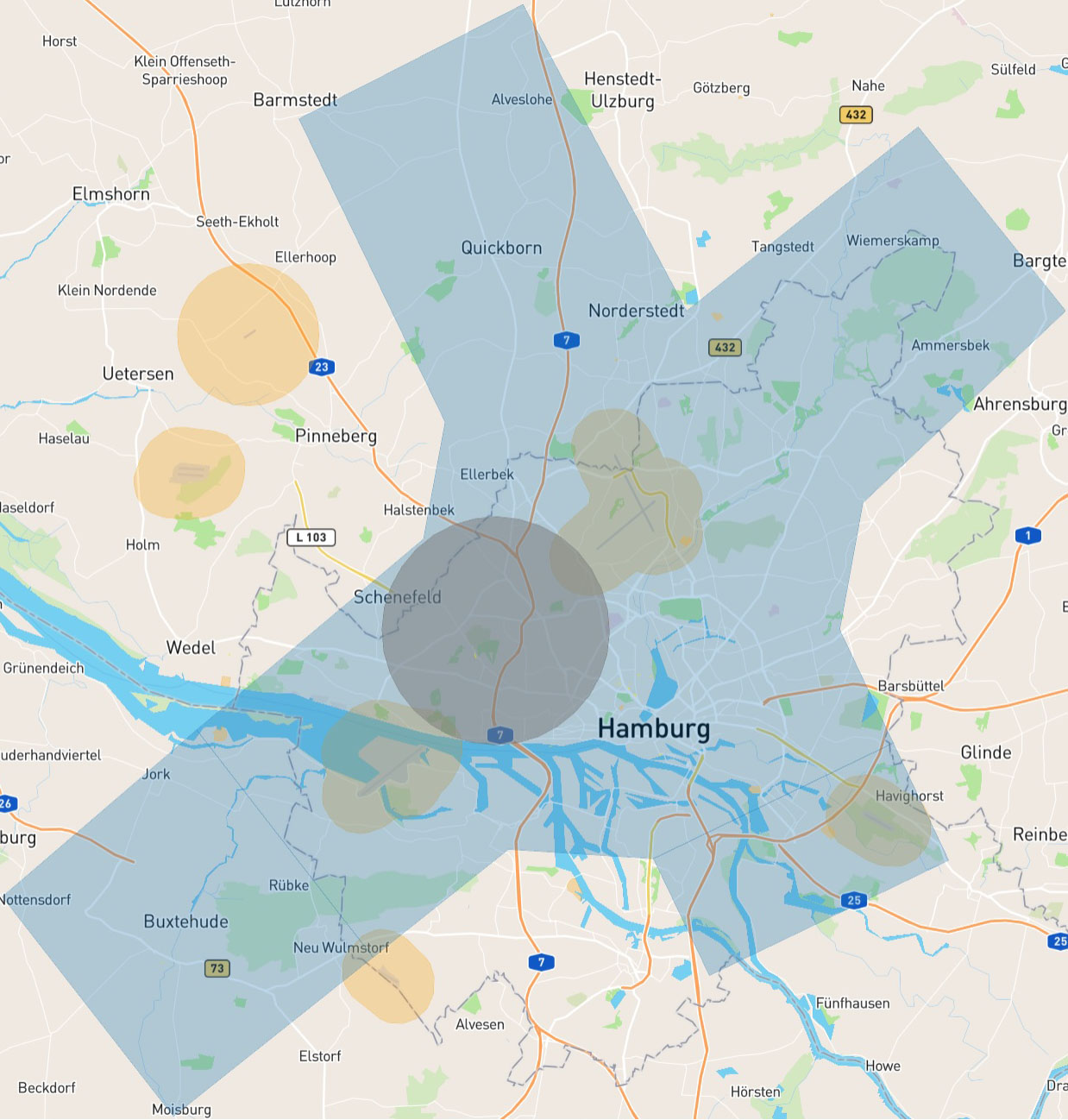
This further supports my suspicion that DJI simplifies the NF zone by defining a box with the corners representing the furthest extent of the NF zone. When I look at the Class D airspace around the Hamburg Airport it's a complex shape but I looked at the North, South, East and West most points and here's what I get:
North most point = N53 49' 30.01", E9 54' 59.16"
South most point = N53 24' 08.43", E9 41' 33.72"
East most point = N53 42' 32.08", E10 15' 52.88"
West most point = N53 29' 09.94", E9 34' 56.51"
So, I think what DJI is doing is creating a box with a NW corner at N53 49' 30.01", E9 34' 56.51", and the SE corner at N53 24' 08.32", E10 15' 52.88". With that as the coordinates in the DJI database then your location, which is outside of any no fly zone, is put within the box defined by DJI.
Here's the Class D NFZ I think DJI has around the Hamburg Airport. I think the NFZ within the DJI database is the larger box defined by the furthest extent in any direction. That is, anywhere in the box is not permitted because DJI chose to use a simplified box to save space.
Brian
Let's not forget that these tools are 2D not 3D. The tools can't be certain how high you might try to fly so if class E is above .you at a low enough level, it may represent it as if it was down to ground level.
DJI might not be able to be too detailed in zone boundaries as much of it is embedded in firmware/non volatile RAM which may be limited in available space. It may even only use circles which only require a point and radius
Sent from my HTC 10 using PhantomPilots mobile app
DJI might not be able to be too detailed in zone boundaries as much of it is embedded in firmware/non volatile RAM which may be limited in available space. It may even only use circles which only require a point and radius
Sent from my HTC 10 using PhantomPilots mobile app
Let's not forget that these tools are 2D not 3D. The tools can't be certain how high you might try to fly so if class E is above .you at a low enough level, it may represent it as if it was down to ground level.
DJI might not be able to be too detailed in zone boundaries as much of it is embedded in firmware/non volatile RAM which may be limited in available space. It may even only use circles which only require a point and radius
Sent from my HTC 10 using PhantomPilots mobile app
I think DJI uses two geometries: circles and rectangles. For most airports its a circle but for more complex shapes they use a rectangle as I listed above. It is likely the space limitations in firmware/storage result in the use of just two geometries. A circle is a lat/lon with a radius and a rectangle is two lat/lon pairs.
Brian
GadgetGuy
Premium Pilot
- Joined
- Jun 18, 2015
- Messages
- 6,881
- Reaction score
- 2,199
Similarly, because AGL cannot be calculated by a barometer over changing terrain heights, DJI asumes the world is flat, when it isn't, and puts in a hard limit above your launch point of 500m, even though you can easily stay within 50m AGL while ascending a 600m hill from the base, and yet you will be unable to reach the top, as the aircraft will refuse to ascend above 500m!I think DJI uses two geometries: circles and rectangles. For most airports its a circle but for more complex shapes they use a rectangle as I listed above. It is likely the space limitations in firmware/storage result in the use of just two geometries. A circle is a lat/lon with a radius and a rectangle is two lat/lon pairs.
Brian

Similar threads
- Replies
- 3
- Views
- 4K
- Replies
- 9
- Views
- 2K
- Replies
- 1
- Views
- 2K
- Replies
- 5
- Views
- 3K


