- Joined
- Apr 8, 2019
- Messages
- 21
- Reaction score
- 0
- Age
- 34
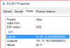
hey guys i'm wondering which elevation is correct...
i have GPS coordinate from my photos and
i have processed from RTKPost and extracted my geotag coordinates.
I don't understand why it's different i haven't changed any setting to adjust too much.
which one is more reliable to use? i assume that the one from RTKpost....?
and elevation is completely different can someone explain meaning for those two elevation difference? and which one to use when i process in pix4d?
thank you.