Dji software caused to lost my drone

So your thought is it probably ran out of battery before it landed?

Wow, I was in a hurry, I didn't even catch the 40+ mph at 600+' during the end of auto landing, was just looking that home point was increasing. :eek:

Rod

Not necessarily. It switched to autolanding when useful time dropped to 170 s and estimated landing time was 180 s. My guess is it had enough battery to land, especially since the wind speed, and thus power drain, will have decreased as it descended.
 
  • Like
Reactions: RodPad
At 1500ft alt, yes wind speed "Might" be a issue, but look at airdata weather.... 8mph +/-... was that the issue? The thing catching my eye was remaining battery vs.MPH speed....??? Was the controller sending panic input resulting in catastrophic screaming results?....(Found a bolt and flange near the museum entrance).

See post #14. Wind speed was an issue - there is no "might be" about it.
 
See post #14. Wind speed was an issue - there is no "might be" about it.
Don't know where your post linked from... I am going from original posts link of airdata..... That "Might be" where I'm coming from...
 
Don't know where your post linked from... I am going from original posts link of airdata..... That "Might be" where I'm coming from...

My links are to the AirData computed wind maps for the two segments of the flight under discussion. Or you can look directly at the pitch/roll data from the txt log files if you don't trust the AirData computed values.
 
Yeah, I notice your link was different, I didn't back and look at the original, thought I just overlooked that last night. ;)

Rod
 
Yeah, I notice your link was different, I didn't back and look at the original, thought I just overlooked that last night. ;)

Rod

The OP probably does not have one of the AirData subscription levels that gives access to the computed wind maps. I downloaded the original txt log file and re-uploaded it to my AirData account, and then shared the wind maps.
 
The point that got me nervous was that the RTH point after the app crashed just changed and drone was already landing, I think there I lost myself, well not so experienced but I have flown a phantom 4 pro multiple times, never happened to me to be in the same situation. About the wind I guess that I didn't paid attention and I think that is my fault, I was thinking that at hight altitude the wind will be so powerful. I have to search more at that location, still hope to find it back... Even if it a crashed. I have an another one crashed also by a friend. In this case about the coordinates, in the video that I've uploaded, seems that the drone went far away from what GPS was indicating...
Alex......i looked at the area that your drone went down in and i also see how its very heavy wooded with trees close together and they are also very high too....I wished i could come help with the search i really do.."Good Luck " and let us know here on this thread what you did we all Hope that you find it !.......i would think reflective tape on the four pods of a drone would sure make a lost drone very easy to spot with a very bright LED flashlight at night !
 
Sounds like user error, not software error. It's not DJI's fault that you didn't put a ceiling cap on the height, and it's not DJI's fault that you were not able to fly via line-of-sight (an essential skill to know for this very reason). 500m is entirely unnecessary, and you should put a ceiling limit on it well below that. Being that mine cruised at 35+mph, it's not a slow drone, either. You should have lowered it by around 400m and brought it home.


One of the lessons learned when flying my Phantom 4 Pro is expect the unexpected. Taking off in high winds (over 10 MPH) its easy to encounter 20 to 30 MPH gusts. Guess what? Your aircraft depending on the Flight Mode can stay with these gusts and be carried along especially if the pilot is disoriented. In high winds if your aircraft appears to be moving away I learned you must switch to sport mode to increase power to return home otherwise you may not be able to overcome the headwind. Also check the dji Go app for the aircraft heading if you loose VLOS so your not adding to the problem by flying further away. Least not forget your communications range is typically affected by a lesser extent horizontal distance verse verticle distance. Remember the antennas are typically orientented for horizontal gain. Think of the antenna gain as a V on its side with the right side level on the ground axis. The left side of the V rising in elevation as it extends out toward the horizon. The further you fly horizontal the better your signal at a verticle height. If you fly vertical directly above your signal strength is much less because you're not using an omni directional antenna and outside the V. So 120 meters isn't typically a problem but 500 meters very well could be unless you turn your controller vertical or extend your antennas straight out so they too are horizontal. Remember the WiFi signals are very low power and regulated to be so for short range communications. The dji equipment is about 100mw where as most common home WiFi routers are in the 20-50mw range.

In the U.S. the FCC regulates WiFi to no more than 150mw unlicensed and 1000mw (1 watt) on the 2.4GHz and 5 GHz Bands dependant On Channel. The EIRP based on antenna gain is also regulated. There are commercial point to point and multipoint applications using highly directional antennas (e.g yagi's and dishes) which can bring effective power to much more. So you can see why you have longer range with your drone vs. your home WiFi.
 
  • Like
Reactions: MotorCycle-Man
I live at the SE corner of Stingray Point, Deltaville, VA, USA, on the water (Chesapeake Bay). Was given a Phantom 3 SE as a present last month. Am a newbie. Testing height and distance variables, yesterday I flew it straight out, SE, over open water toward Gwynn's Island, abt 2.5 miles away.

For the first leg, I flew at a height of 50 feet until I got 1,500 feet out, offshore.

The wind at Home point, ground level, was between 1 to 2 mph, from the N. (I flew out SE.)

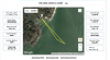
In the track image you will see a squiggle almost near the end. I had the drone do a 360 for video of the land and our house, and altered course slightly, hoping to see the Piankatank River marker, Green # 3, on the screen. Could not as it is abt 1.5 miles offshore. Then, at 1,500 feet distance out from Home, I told it to RTH. Per my settings (cause of lots of tall pines inland) it rose to 250 feet, then flew a straight line back.
Later, I uploaded my files to the Airdata website.

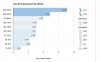
Attached is a screenshot of both the track at Stingray Pt and, more significant to this discussion, the info re the wind during the trip.

At an elevation of 50 feet, en route out, the wind ranged from 3.16 to 3.51 mph.

For the RTH, at 250 feet, the wind jumped up to 10.69. So, it appears that the wind increased almost three fold, presumably, three times the speed and also three times the force on the body of the aircraft. WRONG!

While the speed increase was threefold, the wind force/pressure was much much greater.

As a sailor, it is my understanding that, as wind speed increases, the force on the sail increases four times. So a doubled increase from 3.5 mph to only 7.0, in terms of opposing pressure on the aircraft body, is a four times increase. Change facts, assume 5 mph v. 10 mph, a quadruple increase in wind force against the AC body.

So, for an elevation change from 50 feet at 3.5 mph wind, to 250 feet and wind at 10.69, the wind impact on the AC was much much stronger. When the AC left Home, there was hardly any wind at ground level. Fifteen hundred feet out from shore, at an elevation of 250 feet, there was a strong wind force opposing the RTH.

If I had gone to 400 feet, or perhaps 500 feet, twice as high, I too might have had difficulty with a successful RTH.

It was a real eye opener for me and, with this thread I am going to revisit my RTH height to a point perhaps only 20 feet above the highest trees.

Very enlightening thread. Thanks.
 

Attachments

  • 2018.0216.flight.map.png
    2018.0216.flight.map.png
    694.9 KB · Views: 458
  • 2018.0216.flight.windprofile.png
    2018.0216.flight.windprofile.png
    143.2 KB · Views: 401
Last edited:
WOW.......wished i could like your story many more times then One !.......Thanks for the post and yes.......That makes me Love My P3-SE even more too ! Three Cheers for the P3 SE ! ))) ))) )))
 
  • Like
Reactions: PeteChesBay
I lost my Dji phantom 3 advanced some hours ago. The app just crashed on Google Pixel XL, Android 8.1, Feb patch with the lastest Dji software before phantom 4, updated all the time.
Why they are not responsible for their software?


DJI Flight Log Viewer - PhantomHelp.com/

Airdata UAV - Flight Data Analysis for Drones


These are the log files, this is just one flight, no landing just the crashing app that lead to this. I tried to search for but I couldn't find the drone... Who I should write to ? Thanks guys, this is the last hope...
I will be "that guy" who points out the obvious: Spanish drone law forbids flying over cities, forbids flying beyond line of sight and forbids flying higher than 120m. You violated all 3 rules, and crashed into an heavily inhabited area. Hopefully nobody got hurt. And, based on the analysis of the data, you did not have flight awareness (wind speed at height can be 10x the wind speed on the ground), making your flights even more dangerous overall

I'm sorry to say, but it's people like you that give this hobby a bad name and will force legislators to impose draconian rules on everyone
 
So, flying while blindfolded over enormious crowds while drinking a beer at night from your car is out of the question?
 

Recent Posts

Members online

No members online now.

Forum statistics

Threads
143,094
Messages
1,467,602
Members
104,980
Latest member
ozmtl