

height
-
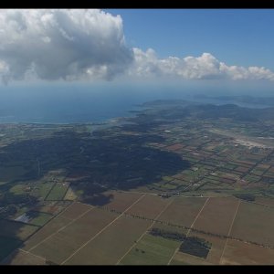
DJI Phantom 3 Height Test, Top Max Altitude 4K 1250 meter with relaxing coast views
This footage I dug out from a trove recorded many years ago, this flight actually was the trigger for me to decide to go into drones. At the time you could r...- walterbenedikter
- Media item
- altitude height max phantom top
- Comments: 0
- Media category: Aerial Videos
-

Map of earth @5 ft.
Maybe im just missing it in the instructions. I would like to make my P3 fly at 5 ft above the ground, NOT 5 ft above the starting elevation. Any suggestions would be nice.- PaddyDelmar
- Thread
- height height above actual ground map of earch not above starting point
- Replies: 10
- Forum: General Discussion
-
very technical question. someone suggested i ask it here.
I could really do for a set of schematics for the P3. I am thinking about replacing the ground sensor that has a range of 10ft with a 120 ft Lidar. Does anyone know information about the power and data cable from the ground sensor currently used in the P3. Has anyone done this before so they can...- PaddyDelmar
- Thread
- height lidar schematic
- Replies: 0
- Forum: Surveying and Mapping
-
This is a very technical question. I hope this is the right thread
I could really do for a set of schematics for the P3. I am thinking about replacing the ground sensor that has a range of 10ft with a 120 ft Lidar. Does anyone know information about the power and data cable from the ground sensor currently used in the P3. Has anyone done this before so they can...- PaddyDelmar
- Thread
- height lidar schemetic
- Replies: 2
- Forum: Phantom 3 Standard
-
N
problems in the height of the photos
hello people I make a query yesterday take 2 pictures of the same place at different heights and the heights appear wrong because the photo at higher height fugura with less height than the other. and is more to take a picture when I take the drone, and figure 44 meters to heights in the photo...- nicolaschiaradia
- Thread
- height phantom 4 pro photo problem sensor
- Replies: 9
- Forum: Phantom 4 Pro Help
-
S
Determining Flying Height
Generally, how do users determine elevation to fly for mapping missions? Using Litchi for example the height above ground is set in the app prior to starting mission, and app controls flight without user input.- snownut
- Thread
- height
- Replies: 3
- Forum: General Discussion
-
S
Why P4P video size changed between recordings?!
Hello All, When I'm recording several videos during the same fly with 1920 width settings, the height of the recorded video is always different: 1072px then 1048px then 1080px then 1064px ... It should always be 1920 x 1080 xp!!! What's happening??- sramk
- Thread
- changes different height resolution video
- Replies: 0
- Forum: Phantom 4 Pro Help
-
B
Disable Max AGL Limit
I'll preface by saying... I'm NOT attempting to circumvent FAA recommendations so please don't chastise me for asking this question without seeing & understanding the context. I'm standing near the base of a +2,000-ft mountain and launching my P3P. I want to fly up the side of the mountain...- benthinking08
- Thread
- agl altitude asl disable hack height limit max altitude override settings
- Replies: 86
- Forum: Firmware
-
S
RTH Height adjustment gone
I completed the latest updates to both the remote controller and my P4. All is fine but the option to set my RTH height is gone. I cannot find it anywhere in DJIGO4. I do have the sensors turned on so I'm wondering if that has anything to do with it. i do get a warning on take off that the RTH...- spideratc
- Thread
- height rth
- Replies: 3
- Forum: Phantom 4 Help
-
J
Distance and height stuck at 30m
After the new firmware on my p3s the drone is stuck it seems in beginner mode. Loged in to DJI , rebooted phone and app (3.1.4 dji go) .re installed go app. Nil fix. Tried updating Dji go to 3.1.10 and app crashes as soon as camera view comes up.cleared cache and data re installed 3.1.4 go app...- Josecoelho
- Thread
- distance distance and height stuck at 30m height phantom 3
- Replies: 21
- Forum: Phantom 3 Standard
-
B
Top Altitude Definition???
Howdy folks from the great southern state of Tennessee!!! I'm hoping you can help me with something. I've searched the forums for some insight to this topic but can't find anything. On the flight log page of the my DJI GO app, there is a heading for "Top Altitude". What is that referring...- benthinking08
- Thread
- above agl above asl altitude ceiling height max altitude top
- Replies: 12
- Forum: Phantom 3 Pro/Adv
-
M
How are you getting your height measurements ? (for buildings / roofs)
Hi folks, How are you getting your height measurements ? (for buildings / roofs) One option is going through the Drone deploy browser and drawing lines on 2d. An auto cad option ? (measuring height in point cloud of auto cad looks tedious) Virtual Surveyor has a height measurement tool...- mmddmmdd
- Thread
- autocad buildings drone deploy height mapping measurment pix4d roof virtual surveyor
- Replies: 8
- Forum: Surveying and Mapping
-

Max Alt = 400', but POI = 600' How to do this?
I have my P4's max altitude setting at 400'. I launch along the side a small mountain (gradual incline) and the Point-of-Interest object (POI) I would like to video is on the ground but 600' higher than my launch site. Technically, the POI is only a few feet above ground level (AGV). Will my...- SoCalDude
- Thread
- altitude height high poi maximum altitude mountain poi
- Replies: 7
- Forum: General Discussion
-
J
Is it possible to log gps/height level data with the Phantom 2 Vision+?
My research lab has a Phantom 2 Vision+ and I was wondering if it would be possible to log gps and height level data during flight and save it?- justiliang
- Thread
- gps height log data phantom 2 vision +
- Replies: 2
- Forum: General Discussion
-
F
Lichi Missions: Height of waypoints not honored?
Hi all, I am new to Lichi (the P2V+ free Android Version). I did some experiments with the Lichi Missions mode and have some concerns regarding the height of waypoints. In the DJI P2+ Vision app, using groundstation it seems that heights of waypoints are always honored, meaning if the phantom...- freak42
- Thread
- elevation height lichi mission waypoints
- Replies: 3
- Forum: Phantom 2 Vision+ Discussion
-

Improve of the altitude of my Drone
Hello I have only had my drone a few days and I was wondering how I can improve the altitude of my drone without opening the controller, I am currently maxing out at 1,100 feet I have two windsurfers attached.- riverphantom3
- Thread
- altitude height
- Replies: 6
- Forum: Phantom 3 Standard
-
A
What are the 20 tallest buildings around here?
Before flying it's handy to know what the tallest buildings / structures are in the area. With over 10 million building heights throughout the US Hivemapper can tell you. Hivemapper | 3D map for drone fliers Twenty-tallest-buildings by Ariel@Hivemapper posted Nov 17, 2015 at 7:16 PM- Ariel@Hivemapper
- Thread
- building height
- Replies: 0
- Forum: General Discussion
-

Phantom 3 - flying below ground level ?
I've been flying Phantom1 for a couple of years, and getting a P3A in next few weeks, so have been reading up but cannot find anything on this. I am planning to do some video off a cliff, so will take off from top of cliff, then fly along cliff face (~10M below take off position), and hoped to...- jamesb72
- Thread
- advanced altitude below ground height home negative phantom 3 position
- Replies: 6
- Forum: Phantom 3 Pro/Adv
-
I
Height from where?
Look at my beautiful drawing. The pilot is standing 50 meters above sea level at the bottom of a mountain that's 500 meters height. The phantom is 50 meters above the mountain. What is the real height? is it sea level to drone = 50 + 500 + 50? or is it mountain top to drone = 50? or it's pilot...- Itay
- Thread
- height reception
- Replies: 46
- Forum: Phantom 3 Pro/Adv