- Joined
- Feb 27, 2014
- Messages
- 448
- Reaction score
- 24
Re: Vision+ Utility Flight Logger Dashware Demo & help neede
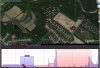
We just converted your csv file to kml one and import it to the google earth. one attachment is the dashware import. and the other is the screenshot of google earth shows the flight path that looks like a flight that went straight up and straight down. we also emailed you the kml file for your reference.
flyNfrank said:ocatcr said:flyNfrank said:ocatar, I seem to now have trouble getting the data in line with dashware. I went through the file and cleaned up any BS entries. Getting the Map display in sync is my only real problem. It kind of seems like the map is running backwards from what it needs to?
I know the map begins to log as soon as the battery is enabled, and then continues right into the point when the motors are enabled.
I opened a older file next to the my last flight for comparison differences, but I was unable to see anything out of spec from each of the two. Mentioning this to you is all I have left with trying to figure out what's wrong.
Next question I have is, What is the purpose of the message box with message about that said to not not shut down the quad. which was after installing the last app update?
Also, in the Logger, what Power is being logged? Is it quad power, or battery power, or?
1. Refer to Dashware manual. To synchronize, locate a spot in the video that corresponds to a spot in the data. The slider below the video moves through video time, the slider in the Synchronization tab moves through the data time. I find the easiest is to look for where you first start moving in the video. Then locate where the speed first starts going up in the data. Click the “Sync with video” checkbox in the Sync tab to sync them together. Playback your video. If the data looks a little off, uncheck “Sync with video”, adjust, and then recheck “Sync with video”. You can make fine adjustments with the < and > buttons on either side of the play button (below video or in sync tab). By default they move by 0.1 seconds. Holding Alt makes them move by 1 second.
2. The message box with message about that said to not not shut down the quad tell you that the server program is being upgraded.
3. the logged battery is the quad battery level that is same as the level shown in the DJI Vision app.
I have a feeling you haven't used dashware software to see if your app is still functioning ok or not, lately. I'm not flaming on you, and I don't mean for it to appear like I am if it seems that away to you. Today I have tried to point out to you that the mapping part of the syncing process has changed.
If I launch my quad and fly straight up and level off at 770ft, and then descend straight down and land, then power off the quad. What would you expect my map data to look like? Should it resemble a flag pole, or a birds nest?
Before starting the motors, the logger records all activity once it has power to do so. The issue seen is what I have heard referred to as "gps drift". I know nothing about it other then the name I mentioned. It does this with flytrex all the same. But, there is useable data along with a mapping display that resembles the flight. Flytrex core2 with display the birds nest and the flag pole in a straight up & down flight.
I have only checked a couple of the current features you have set to log. One is ok where the other is off. I found the alitude to current be off by 60ft when I checked earlier in the night.
At this point I'm hoping between you and your crew, one of you may know what is needed to cure this issue.
We just converted your csv file to kml one and import it to the google earth. one attachment is the dashware import. and the other is the screenshot of google earth shows the flight path that looks like a flight that went straight up and straight down. we also emailed you the kml file for your reference.