Restricted or Special Use Airspace

Thank you, this is the best description I have I seen thus far. I opened Skyvector and saw something I had never heard of before, DROTOMS. I did not realize the FAA was putting out NOTOMS specific to drones. Learning sectional maps is my goal, thus my questions.
I will do my best to answer any questions you have on charts. They are fairly easy for me and once you learn the information in the Legend they are quite easy to read. You still have to check apps like Aloft to make finding things like NSUFR’s easier.

A trick on using SkyVector is to use the World VFR to locate the area. Then if you need to access the Legend, switch to the local VFR sectional like New Orleans, Jacksonville, Miami, etc. The Legend will always start in the top left of the local sectional.

Class B - solid blue line

Class C - solid magenta line

Class D - dashed blue line

Class E - dashed magenta line

These are areas that will require LAANC approval.

If you have a local flight school check with them to see if they have any out of date paper sectional maps they would sell you for cheap or free. Once out of date they cannot be used on a flight, but they make a great learning tool.
 
Last edited:
  • Like
Reactions: captainmilehigh
@DoomMeister Once again thanks for your help. This brings me back full circle to my original question. The sectional chart for A-292 has a caution of high volume of aircraft from surface to 17,500'.
Aloft has an effective time frame and a level of Low Altitude Only. What does Low Altitude Only mean since A-292 is SFC to 17500'? Can I fly a UAS in A-292 during the Alert area effective times?
If I did not have Aloft where on the sectional chart or any FAA publication would I get the information that R-xxxx areas are no UAS fly and A-xxx is permissible?
 
Last edited:
@DoomMeister Once again thanks for your help. This brings me back full circle to my original question. The sectional chart for A-292 has a caution of high volume of aircraft from surface to 17,500'.
Aloft has an effective time frame and a level of Low Altitude Only. What does Low Altitude Only mean since A-292 is SFC to 17500'? Can I fly a UAS in A-292 during the Alert area effective times?
If I did not have Aloft where on the sectional chart or any FAA publication would I get the information that R-xxxx areas are no UAS fly and A-xxx is permissible?
Refer to Chapter 15 of FAA-H-8083-25B. The information it states can be found on the back of the chart is now in the margins on the front due to keeping digital and paper versions consistent.

Another difference is it states that in Alert areas both pilots are equally responsible for see and avoid. That is for crewed aircraft. UAS pilots must always see and avoid crewed aircraft.

Contact with the listed Control Agency must be by phone as contact by radio is only permitted from/to crewed aircraft.

You can get airport data here https://www.faa.gov/air_traffic/flight_info/aeronav/digital_products/dafd/search/ that will have contact data for the airport. Enter the 3 letter code like JAX for Jacksonville Intl. and then select the small pdf at the far right in the resulting search.
9082CB10-B2E5-4E31-9F22-F415DB1FF44B.jpeg

9F807876-C859-4802-9BB1-573687136BB6.jpeg

These are the tables found in the margins on the sectionals that describe the SUA areas on the chart.
 
Last edited:
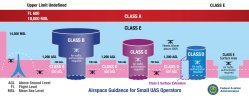
This is a great reference slide the FAA did fairly recently.
 

Attachments

  • airspace_classes_large-2.jpg
    airspace_classes_large-2.jpg
    541.9 KB · Views: 131
This is a great reference slide the FAA did fairly recently.
That is a good graphic for §107 certified pilots. The issue with recreational pilots are they must stay within 400’ AGL even when obstacles are present. They are not allowed the 400’ over within 400’ of an obstacle as allowed in §107.51(b) as shown in the graphic for the obstacle on the left side.
 
Last edited:
It is a surface extension to the Class D airspace and clearance is not required. The 400’ AGL line should have penetrated it up to the Class D. If you use the link for the Class E I posted you would find it to be type E4 which doesn’t require authorization.
 
Did you download the Handbook of Aeronautical Knowledge? Chap. 15 explains SUA as well as other airspace.

Yes I have downloaded it and have read CH 15 twice. Using CH 15 and the Skyvector site, I understand SUA much much better. I now also understand that restricted airspace may not start at the SFC. The margins on the sectional charts provide more information than I ever imagined.
I still do not desire to get my Commercial Part 107 for several reasons but now I am a more informed recreational pilot. Thank you.
You are most welcome. I have not tested for my 107 yet although I have been studying for it. If you have any other questions that arise feel free to ask. If I don’t know the answer I can usually find it.

For the property you are interested in it seems quite close to I-10. Not sure they would be doing any low level OP’s that close to the Interstate. You might try contacting the Base Operations Office explain your situation and ask about your planned recreational drone flights over that property. Explain that you restrict your flights to a maximum of 400’ AGL and do not want to interfere or be a nuisance to flight operations and would like to initiate a letter of agreement allowing you to fly there within limits. It is always worth a try. The worst they can do is say no.
 

Recent Posts

Members online

Forum statistics

Threads
143,094
Messages
1,467,602
Members
104,980
Latest member
ozmtl