Great video, well done. Liked the shot of the fountain at the Bellagio. To crowded for me, I wouldn't want to fly down on the strip.


You are using an out of date browser. It may not display this or other websites correctly.
You should upgrade or use an alternative browser.
You should upgrade or use an alternative browser.
Phantom 3 Vegas Shots
- Thread starter Adam Kontras
- Start date
ianwood
Taco Wrangler
DJI's no fly zones are often wrong. You need to check with FAA airspace classification. Here is KLAS airspace. It's class B to the ground throughout most all of the metro Vegas area.

That video was amazing!!! Thanks for sharing.
Sent from my iPhone using Tapatalk
Sent from my iPhone using Tapatalk

DJI's no fly zones are often wrong. You need to check with FAA airspace classification. Here is KLAS airspace. It's class B to the ground throughout most all of the metro Vegas area.
It's Class B in the ENTIRE county of Los Angeles (where we both live)
http://vfrmap.com/?type=vfrc&lat=34.201&lon=-118.359&zoom=10
It's Class B airspace in Los Angeles (where we both reside) over the ENTIRE COUNTY:DJI's no fly zones are often wrong. You need to check with FAA airspace classification. Here is KLAS airspace. It's class B to the ground throughout most all of the metro Vegas area.
http://vfrmap.com/?type=vfrc&lat=34.201&lon=-118.359&zoom=10
Surely you're not acting like this prohibits drone use in those areas...
Ian, I could very easily have gone onto your (stunningly gorgeous) Downtown LA footage thread and written "You need to check with FAA airspace classification. Here is KLAX airspace. It's class B to the ground throughout most all of the metro Los Angeles area." But that would just be silly.
Attachments
ianwood
Taco Wrangler
I don't fly in class B or C, ever. Not once. Most of Los Angeles is UNDER class B. As in it starts above 1,000ft or higher.
I don't fly in class B or C, ever. Not once. Most of Los Angeles is UNDER class B. As in it starts above 1,000ft or higher.
So the Class B airspace is different in Los Angeles than it is in Las Vegas? You can fly below 1000 feet in Class B in Los Angeles, but not at ALL in Las Vegas?
ianwood
Taco Wrangler
So the Class B airspace is different in Los Angeles than it is in Las Vegas? You can fly below 1000 feet in Class B in Los Angeles, but not at ALL in Las Vegas?
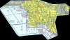
Airspace has a top and a bottom. There can be two or more different types of airspace at a given location depending on altitude. In Vegas it is to the surface (SFC). In LA it is to the surface in a small area around LAX. Other areas it is higher. Here's LAX Class B. Note it starts at 2,500ft in area C which covers a lot of LA.

To the people that don't think we should have to have certifications to fly this, I present that *(&^@# picture.Airspace has a top and a bottom. There can be two or more different types of airspace at a given location depending on altitude. In Vegas it is to the surface (SFC). In LA it is to the surface in a small area around LAX. Other areas it is higher. Here's LAX Class B. Note it starts at 2,500ft in area C which covers a lot of LA.

And if the entirety of Vegas is "no-fly" from the surface up... why on EARTH would there be just a 1.5 mile ring around McCaren? Isn't "SFC" pretty clear?
Also, what site are you getting the google earth maps from? I can't find overlays on google earth...
ianwood
Taco Wrangler
Airspace is not too complicated but as you can see, reading the charts can lead to confusion if you're not familiar with them.
Can't remember where I got the airspace overlay for Google Earth. I'll take a look.
Can't remember where I got the airspace overlay for Google Earth. I'll take a look.
Of course it was. On DJI's map on their controller there is a 1.5 mile radius red circle... and nothing else. On their website there's a larger orange circle... but when I was setting up I followed the map on my controller and made sure I was out of what I thought was a no-fly zone. I'm pretty stunned that in actuality the entire city is restricted from the ground up.Well I live in Vegas and I can tell you that most of your shots are way inside the 5 miles radius of McCarron -- hi MO
ianwood
Taco Wrangler
That's the thing. DJI's no fly zones do not reflect the actual airspace. Their database of airports is still not right (e.g. Burbank airport STILL not on it) and they chose a circle for simplicity whereas restricted airspace is most often anything but a circle.
I will say that the FAA has a lot of work to do too. Before drones, it didn't matter much that class B goes to the surface unnecessarily in many areas since no one had to a need to use other than cleared flights. With drones, that changes. The FAA needs to update their airspace to reflect that helis and drones may use the space below 500ft a certain distance from the airport.
I will say that the FAA has a lot of work to do too. Before drones, it didn't matter much that class B goes to the surface unnecessarily in many areas since no one had to a need to use other than cleared flights. With drones, that changes. The FAA needs to update their airspace to reflect that helis and drones may use the space below 500ft a certain distance from the airport.
Thank you. It was unbelievably stressful.With all that said-- still a very cool and well done video
")
The more I did it, the easier it got. When I started, the flight times were 5 or 6 minutes (and it felt like a half-hour). By the last one I was around 13 minutes, but never pushed it the limit. Once I saw I got a shot I liked, I wanted to take it down and runaway in my car. I had to keep telling myself to slow down and get more...Great video, well done. Liked the shot of the fountain at the Bellagio. To crowded for me, I wouldn't want to fly down on the strip.
Great video... you did break all the rules. Understand the nerves. Glad you made it and don't ever do it again... until the FAA grants you a COA, which they will never do. And, you have insurance...
- Joined
- Jun 27, 2014
- Messages
- 142
- Reaction score
- 71
"Professional" drone operator?
Most on this site say there's no such thing (legally).
I am DYING to hear an explanation.
Most on this site say there's no such thing (legally).
I am DYING to hear an explanation.
"Professional" drone operator?
Most on this site say there's no such thing (legally).
I am DYING to hear an explanation.
http://money.cnn.com/2014/11/25/news/drone-pilot-degree/
This business exists outside of this board.
Similar threads
- Replies
- 17
- Views
- 3K
- Replies
- 4
- Views
- 727
- Replies
- 15
- Views
- 3K
- Replies
- 15
- Views
- 1K
- Replies
- 0
- Views
- 297


Recent Posts
-
-
 North Jersey, Very new old guy trying to get off the ground with a P330Z Phantom 2
- Latest: captainmilehigh
-

-
