Lost my P4P

Joined
May 20, 2017
Messages
12
Reaction score
0
Age
73
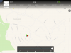
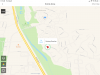
I was just going to take a quick flight around the neighborhood and my drone disconnected and took off. I was patiently waiting for it to return but no such luck. The last thing I saw was a GPS error and off it went. I am sure there was some element of pilot error involved but it had set RTH before it took off. Here is the flight record. Any advice about what happened and where I might start looking. I followed the Find My Drone app but t's not where the app indicates.
 

Attachments

  • DJIFlightRecord_2019-05-08_[15-20-09].txt
    114.5 KB · Views: 356
  • 2019-05-08 15_21_57-07JDEAD00201NV.dat
    46 bytes · Views: 273
First question - is this the correct takeoff location?

111111
 
At the point when the log file ends the aircraft was 180 ft high and just 50 ft away laterally. You should have been able to see and hear it. Could you tell if it continued to fly in that direction, or did you lose visual and audible contact at that time?
 
I was looking down at the RC trying to see what was happening. From the last DJI screen it was headed east. In a straight line about .5 miles is a military base (camp bullis)
 

Attachments

  • C613F145-D238-48CF-B1E8-4CBE4134E6D1.png
    C613F145-D238-48CF-B1E8-4CBE4134E6D1.png
    671 KB · Views: 415
  • E903DC84-C467-4B0A-8CB1-8BB1A3A88617.png
    E903DC84-C467-4B0A-8CB1-8BB1A3A88617.png
    181.4 KB · Views: 425
I was looking down at the RC trying to see what was happening. From the last DJI screen it was headed east. In a straight line about .5 miles is a military base (camp bullis)

I know what the screen showed because that's in the log file. The question is whether you continued to see or hear it after it lost connection.
 
Interestingly I am not sure. I a, very careful checking the battery before flight but you never know.
 
At the point when the log file ends the aircraft was 180 ft high and just 50 ft away laterally. You should have been able to see and hear it. Could you tell if it continued to fly in that direction, or did you lose visual and audible contact at that time?
Does this map in Find My Drone provide a realistic expectation of where my drone ended?
 

Attachments

  • IMG_0336.PNG
    IMG_0336.PNG
    846.5 KB · Views: 367
Does this map in Find My Drone provide a realistic expectation of where my drone ended?
Find My Drone usually shows the last known aircraft location from the most recent TXT flight log on the mobile device. Do you have a more recent TXT flight log than the file you attached above?
 
  • Like
Reactions: sar104

Members online

Forum statistics

Threads
143,066
Messages
1,467,358
Members
104,935
Latest member
Pauos31