- Joined
- Dec 26, 2016
- Messages
- 140
- Reaction score
- 61
- Age
- 64
I’m going up to Harpers Ferry, WV tomorrow morning, looking for a legal place to launch from. The National Park boundaries extend along most of the Potomac and Shenandoah Rivers in the West Virginia elbow, the Maryland side way up the mountain and the areas upstream Shenandoah on both Virginia and West Virginia sides. See the NPS map.
Maps - Harpers Ferry National Historical Park (U.S. National Park Service)
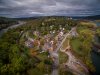
The most likely areas are near the two bridges, the first adjacent to the Harpers Ferry Amtrack Station and the 2nd bridge where the Appalachian trail crosses the Potomac River.
There does appear to be a little carve out right near the point on the West Virginia side next to that 2nd bridge, very close to the historic area. I believe it may be land owned by one of the railroad companies. That looks like the ideal place with all of the major points of interest accessible for filming. Weverton cliffs, historic areas of the town, railroad bridges, bridge ruins, rock islands, the C&O canal and truly one the most beautiful historic scenic areas you’ll ever witness.
I have an indelible memory of crossing that 2nd railroad bridge in complete and total darkness on my first ever visit to Harpers Ferry 40 years ago, attempting to find a connection to the C&O canal on the opposite side of the river from the train station, based on someone’s sketchy directions I didn’t bother to write down at a keg party a few weeks prior. We had no map, no flashlight and had never backpacked before. Stepping from tie to tie barely visible about midway, we hear a train coming through the tunnel. We didn’t know about any tunnel, but saw the light, heard the air horn. We find a thin rickety railing and climb over it, hanging on for dear life with 50 lbs. of canned food, wine and beer on our backs. It was at this point we realize that we’re hanging on that railing directly over a river... a 150 yds wide Potomac river. It was so dark, we could only hear the river 40 ft. below. As the train came through the tunnel, our sphincters tighter than a bugler’s lips, it veered off to what was apparently another railroad bridge roughly parallel to the bridge we were hanging over, splitting a Y in the tracks. We did eventually get across that bridge, vault our packs over the 8 ft. fence we had to climb over, cross a 2nd set of tracks, find what appeared to be the C&O towpath (canal not watered in this portion), and set up a lean-to with plastic (for some unknown reason cause I packed a tent). It rained.
So, you can see that Harpers Ferry holds a very special place in my history of fawlty endeavors. The fall colors should be outstanding this week and Harpers Ferry is a beautiful place for 4 batteries worth of flights. If anyone knows good launch spots and/or wants to meet up, let me know.
Maps - Harpers Ferry National Historical Park (U.S. National Park Service)
The most likely areas are near the two bridges, the first adjacent to the Harpers Ferry Amtrack Station and the 2nd bridge where the Appalachian trail crosses the Potomac River.
There does appear to be a little carve out right near the point on the West Virginia side next to that 2nd bridge, very close to the historic area. I believe it may be land owned by one of the railroad companies. That looks like the ideal place with all of the major points of interest accessible for filming. Weverton cliffs, historic areas of the town, railroad bridges, bridge ruins, rock islands, the C&O canal and truly one the most beautiful historic scenic areas you’ll ever witness.
I have an indelible memory of crossing that 2nd railroad bridge in complete and total darkness on my first ever visit to Harpers Ferry 40 years ago, attempting to find a connection to the C&O canal on the opposite side of the river from the train station, based on someone’s sketchy directions I didn’t bother to write down at a keg party a few weeks prior. We had no map, no flashlight and had never backpacked before. Stepping from tie to tie barely visible about midway, we hear a train coming through the tunnel. We didn’t know about any tunnel, but saw the light, heard the air horn. We find a thin rickety railing and climb over it, hanging on for dear life with 50 lbs. of canned food, wine and beer on our backs. It was at this point we realize that we’re hanging on that railing directly over a river... a 150 yds wide Potomac river. It was so dark, we could only hear the river 40 ft. below. As the train came through the tunnel, our sphincters tighter than a bugler’s lips, it veered off to what was apparently another railroad bridge roughly parallel to the bridge we were hanging over, splitting a Y in the tracks. We did eventually get across that bridge, vault our packs over the 8 ft. fence we had to climb over, cross a 2nd set of tracks, find what appeared to be the C&O towpath (canal not watered in this portion), and set up a lean-to with plastic (for some unknown reason cause I packed a tent). It rained.
So, you can see that Harpers Ferry holds a very special place in my history of fawlty endeavors. The fall colors should be outstanding this week and Harpers Ferry is a beautiful place for 4 batteries worth of flights. If anyone knows good launch spots and/or wants to meet up, let me know.