- Joined
- Sep 5, 2021
- Messages
- 3
- Reaction score
- 0
- Age
- 34
Hello! I apologize for using google translate.
I do not know if there are specialists in geology here, but I will describe the problems in detail. For clarity, I will add pictures.
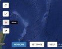
You need to shoot a quarry with DJ Phantom 4 Pro. The route runs from bottom to top with additional points. At approximately the same height on each ledge. I draw the route in the Micromine geological program. Each point has coordinates in the VGS84 system. When importing to MissionHub. the route is drawn off the coast of Guinea. Although I myself am in Kazakhstan. I am trying to use Litchi.
Please, could you help me with the solution of the problem? Or guide me on the right path?
I know that this shooting was carried out on the model of DJI phantom pro.


Thank you in advance.
I do not know if there are specialists in geology here, but I will describe the problems in detail. For clarity, I will add pictures.
You need to shoot a quarry with DJ Phantom 4 Pro. The route runs from bottom to top with additional points. At approximately the same height on each ledge. I draw the route in the Micromine geological program. Each point has coordinates in the VGS84 system. When importing to MissionHub. the route is drawn off the coast of Guinea. Although I myself am in Kazakhstan. I am trying to use Litchi.
Please, could you help me with the solution of the problem? Or guide me on the right path?
I know that this shooting was carried out on the model of DJI phantom pro.
Thank you in advance.