DJI Phantom 4 Pro Flight Record Opinions/Help Please??

Joined
Jan 9, 2018
Messages
6
Reaction score
0
Age
47
Hello everyone, Would everyone please give me their opinion about my flight record? This is my first post and value everyones opinion. DJI is stating -> Based on your flight data, the relative height of the aircraft was 3.5m when the record ended. And the pilot was pushing forward the Elevator stick at that time. With the record ended, we could not know what happened after that and could also not verify the reason why the aircraft did not return home.


However, according to your flight record which you could also review that on your DJI GO 4 app, the aircraft was switched to ATTI mode by the pilot and its horizontal speed even reached 20.6 m/s when the record ended. With such high speed, the ultrasonic and vision system will be affected, so the aircraft could not hold its height perfect especially the aircraft was above the water. And that would also cause the aircraft to fly into the water at the end.

I have searched countless days/hours with help and can't locate the drone. I have DJI Refresh which I bought when I ordered the drone because it states water damage. No where during the purchasing process does it state that I would have to retrieve the drone and send it back in for a replacement. If that was clearly stated I wouldn't have been flying over water for sure. Any help would be much appreciated thank you. If you need anything else let me know and I will get it for you.
Thanks,
Larry

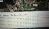
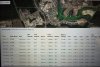
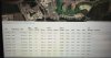
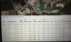
Not sure if this link will work for everyone besides me but this has the map and route. -> DJI Flight Log Viewer - PhantomHelp.com
 

Attachments

  • DJIFlightRecord.zip
    185.5 KB · Views: 261
  • 20180507_180950.jpg
    20180507_180950.jpg
    2.9 MB · Views: 427
  • 20180508_091149.jpg
    20180508_091149.jpg
    4.6 MB · Views: 444
  • 20180507_181028.jpg
    20180507_181028.jpg
    1.5 MB · Views: 433
  • 20180507_181052.jpg
    20180507_181052.jpg
    1.6 MB · Views: 388
  • 20180507_181112.jpg
    20180507_181112.jpg
    2.3 MB · Views: 398
  • 20180508_101339.jpg
    20180508_101339.jpg
    5.3 MB · Views: 427
What exactly are you asking for? We can look at the data for sure, but is there anything in specific that you are questioning?
 
If you are simply trying to verify what you were told by DJI, the data appears to confirm what they are saying. Also, I realize that this is a mute point at present, but always turn off the VPS when flying over water. You really pushed the throttle at the very end......

Flight2 w speed.png
 
  • Like
Reactions: LeoTheKing76
I found this to be an interesting read ->
I am quite familiar with ATTI Mode. Looking back at this data again. The AC had already begun RTH at 3059ft Out after 48.8 sec of signal loss. ( It could have started earlier..no way to know for certain). Still doing a few comparisons when I get a few min. Not quite sure why the altitude loss as of yet.
 
  • Like
Reactions: LeoTheKing76
Best I can tell, and I can't say this is not possible because I have never tried it. It appears that you were attempting to control the AC during RTH. Which doesn't make sense really because you were giving throttle up but your altitude kept decreasing. What was your RTH altitude set for BTW. Looking at the signal losses, the shaded area is the only one that was an uplink loss. The AC initiated RTH there. I will ask another to take a quick glance if you are still wanting more information. @sar104

RTH2.png
 
  • Like
Reactions: LeoTheKing76
Best I can tell, and I can't say this is not possible because I have never tried it. It appears that you were attempting to control the AC during RTH. Which doesn't make sense really because you were giving throttle up but your altitude kept decreasing. What was your RTH altitude set for BTW. Looking at the signal losses, the shaded area is the only one that was an uplink loss. The AC initiated RTH there. I will ask another to take a quick glance if you are still wanting more information. @sar104

View attachment 98608
Thank you as I am new and have searched the entire area for the drone and can't locate it. I have the .txt files and .dat files from my tablet that I was using at the time if that will help ? I appreciate your time with this.
 
Best I can tell, and I can't say this is not possible because I have never tried it. It appears that you were attempting to control the AC during RTH. Which doesn't make sense really because you were giving throttle up but your altitude kept decreasing. What was your RTH altitude set for BTW. Looking at the signal losses, the shaded area is the only one that was an uplink loss. The AC initiated RTH there. I will ask another to take a quick glance if you are still wanting more information. @sar104

View attachment 98608
I was flying low to the water with the VPS on several occasions and didn't have an issue until I switched to ATTI. Just trying to Understand it all . Thanks
 

Attachments

  • 20180507_181112.jpg
    20180507_181112.jpg
    2.3 MB · Views: 356
  • 20180507_180950.jpg
    20180507_180950.jpg
    2.9 MB · Views: 384
  • 20180507_180950.jpg
    20180507_180950.jpg
    2.9 MB · Views: 339
  • 20180507_181028.jpg
    20180507_181028.jpg
    1.5 MB · Views: 374
  • 20180507_181052.jpg
    20180507_181052.jpg
    1.6 MB · Views: 380
  • 20180507_181112.jpg
    20180507_181112.jpg
    2.3 MB · Views: 392
  • 20180508_091149.jpg
    20180508_091149.jpg
    1.3 MB · Views: 391
If you are simply trying to verify what you were told by DJI, the data appears to confirm what they are saying. Also, I realize that this is a mute point at present, but always turn off the VPS when flying over water. You really pushed the throttle at the very end......

View attachment 98599

The log data are really quite confusing because the aircraft appears to be running a custom stick mode, with left and right swapped. In the decoded logs, throttle is elevator, rudder is aileron, and vice versa.

The late switch to ATTI mode by the pilot, 6 seconds before the end of the log, probably contributed to the crash by increasing the aircraft pitch up to 35° and losing some altitude in the process. Throttle was centered and elevator was full forwards at the time, and the problem was simply that the aircraft was very low, moving very fast, and almost certainly just hit the water.
 
Hello everyone, Would everyone please give me their opinion about my flight record? This is my first post and value everyones opinion. DJI is stating -> Based on your flight data, the relative height of the aircraft was 3.5m when the record ended. And the pilot was pushing forward the Elevator stick at that time. With the record ended, we could not know what happened after that and could also not verify the reason why the aircraft did not return home.

However, according to your flight record which you could also review that on your DJI GO 4 app, the aircraft was switched to ATTI mode by the pilot and its horizontal speed even reached 20.6 m/s when the record ended. With such high speed, the ultrasonic and vision system will be affected, so the aircraft could not hold its height perfect especially the aircraft was above the water. And that would also cause the aircraft to fly into the water at the end.
DJI's analysis seems accurate.
They can't tell what happened because the flight record ends just before the crash.
But they can have a pretty good guess based on what the record shows.
Sar104's last sentence above summarises the most likely outcome pretty well.

You were flying back at high speed just a few feet above the water from 1100 feet out with a line of trees between you and the water (if google earth is up to date).
Could you see clearly how high the Phantom was above the water?
Do you know how well the Phantom holds altitude when flying fast in atti mode?.
 
Altitude on your HUD is also defined by your take off position. If you couldn’t see the AC then are you certain that the water level you were flying over was the same?
 
Best I can tell, and I can't say this is not possible because I have never tried it. It appears that you were attempting to control the AC during RTH. Which doesn't make sense really because you were giving throttle up but your altitude kept decreasing. What was your RTH altitude set for BTW. Looking at the signal losses, the shaded area is the only one that was an uplink loss. The AC initiated RTH there. I will ask another to take a quick glance if you are still wanting more information. @sar104

View attachment 98608
-> My return home altitude was 100m thats where I always set it at just to be certain of the trees and obstructions.
 
DJI's analysis seems accurate.
They can't tell what happened because the flight record ends just before the crash.
But they can have a pretty good guess based on what the record shows.
Sar104's last sentence above summarises the most likely outcome pretty well.

You were flying back at high speed just a few feet above the water from 1100 feet out with a line of trees between you and the water (if google earth is up to date).
Could you see clearly how high the Phantom was above the water?
Do you know how well the Phantom holds altitude when flying fast in atti mode?.
-> I could see everything clearly on the tablet but everything happend so fast that I couldn't figure out what happened that's why I posted this so the pros could help me. I've searched the lake which is mostly shallow 8 times 2 times in the dark with lights outrigged on the boat. no luck. I have DJI Refresh and can't find the drone. Any tips would be appreciated. Thanks for the help everyone.
 
-> My return home altitude was 100m thats where I always set it at just to be certain of the trees and obstructions.
That is approximately what the data revealed......The AC climbed to RTH altitude and began return. Looking at the altitude data in Post#6. Just wanted to verify that.
 
  • Like
Reactions: LeoTheKing76

Recent Posts

Members online

Forum statistics

Threads
143,094
Messages
1,467,602
Members
104,980
Latest member
ozmtl