

Don't know if this has been posted/discussed before..
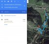
For either manual flying or missing planning (in Litchi or Autopilot) here is a quick way to get an estimate of altitude variation.. If you pick the start & end points and plot directions in Google maps - when the way is shown for driving or Walking only the distance, time and directions are shown..
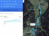
If you pick the Bicycle route as an option, then the elevation variation is shown.. this can give a quick idea of how the altitude is varying in the surroundings.. you can break the path into small distances to get altitude variation and use that to set WP heights in Litchi or similar apps.
This is one way of estimating altitude variation quickly.. and even using it for WP mission planning..
For either manual flying or missing planning (in Litchi or Autopilot) here is a quick way to get an estimate of altitude variation.. If you pick the start & end points and plot directions in Google maps - when the way is shown for driving or Walking only the distance, time and directions are shown..
If you pick the Bicycle route as an option, then the elevation variation is shown.. this can give a quick idea of how the altitude is varying in the surroundings.. you can break the path into small distances to get altitude variation and use that to set WP heights in Litchi or similar apps.
This is one way of estimating altitude variation quickly.. and even using it for WP mission planning..


")


