P3 standard compatible with litchi?

Joined
May 28, 2017
Messages
341
Reaction score
131
Age
58
Location
Searcy, Ark.
I own Mavics and recently acquired a p3 standard.
Will litchi app work with a p3?

Also is there a dji assistant 2 version for p3?

Thank u all
 
Yes sir, Litchi is indeed compatible with a Phantom 3 Standard. I have over 700 miles of fully autonomous waypoint flights logged on my Phantom 3 S, and counting. Haven't used DJI Go at all.
 
  • Like
Reactions: Earls Court
As he says, P3S is litchi compatible.

Actually, the P3S is a fantastic 'sweet spot' for litchi because it's very cheap for what it can do, you aren't throwing £1000 in the air 'autonomously', for a while I used it to test missions before committing the P4P to the same.

I've had Phantoms since P2 days, my P3S was 100% solid/reliable for me. I only sold it because my house wasn't big enough to keep it :)
 
DJI Assistand 2 is for p4series but i don´t know the compatiblity for the P3 series.
 
Best investment I ever made to run Litchi! I always wondered what the hype was all about until i realized how it would extend the autonomous functionality of my P3S. Just pay extra attention to how Litchi calculates altitude at the start or home point as you create waypoints along the way with various elevation changes. Give yourself plenty of safety margin here as my little bird took a spill into the very tops of some tall pines on a high ridge around the lake. Luckily I found it and had the compass wires reattached after they got jiggled. You need those to compute direction during the mission. I've created and run at least 15-20 missions now and it's so simple once you get the hang of it. You can even run sample missions with Google Earth before you lift off if you're interested. Lots of YT vids to check out. Have fun!
 
  • Like
Reactions: Billie Nelson
That altitude safety margin must be generous as Hexhaven pointed out. Flew a 6-mile round trip mission with my Mavic Pro1 recently from a takeoff point 200 feet below the destination loiter area. All my previous flights had launched from a takeoff altitude that was higher than most of the destination area waypoints, and this difference in launch point altitude evidently caused Litchi to fly the craft roughly 50 feet lower than intended.

When I played back the video I noticed right away that my usual 150-feet-above-current-waypoint setting had the drone barely skimming the tree-tops, until finally, a tall palm tree trunk loomed causing obstacle avoidance to take over by slamming the brakes and vectoring the Mavic straight back to the launch point in RTH mode.

An easy 90% of my Litchi flights are conducted with my Phantom3 Standard well beyond signal range as is permissible in this forgotten backwater. If I'd flown the Phantom3 instead of the Mavic Pro1 on that flight, the craft would have slammed full tilt into that palm tree trunk, and I would have been none the wiser as to the nature of the drone's fate, given the remoteness of the tropical jungle where the crash would have occurred.

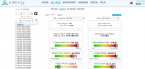
Recently, Litchi screen warnings advising that "elevation data is not available" in the areas I fly, add to the reasons why a generous increase in that altitude error margin is good practice. In my rural locality I would never dream of flying an initial recon Litchi mission below 246-feet AGL now, Just checked my Flight Data odometer reading, and with a total of 114 hours of fully autonomous Litchi missions flown at the standard 17.9 mph cruise speed, the cumulative distance covered is thus 2,040 miles and counting.

Enough rambling from me for now. I've got some more Litchi flight plans to create on the Mission Hub.
 

Attachments

  • Litchi Flight Log.jpg.png
    Litchi Flight Log.jpg.png
    93.6 KB · Views: 84

Members online

Forum statistics

Threads
143,066
Messages
1,467,358
Members
104,935
Latest member
Pauos31