flying a Phantom 4 pro and 4 advanced on an iOS system, same results with both ships.
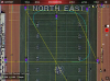
I’ve created some missions by flying a route and creating waypoints as I go for later use. When pulling the mission into Litch mission hub or into the app, I’ve noticed the map is offset by amount 3 meters.
Is there a datum issue that I can fix?
I’m not comfortable creating a mission in Litchi as I need to take to offset into consideration each time. This issue has been there for the last few versions of the app. I’m just getting around to asking about this.
Thoughts and constructive input would be appreciated.