

You are using an out of date browser. It may not display this or other websites correctly.
You should upgrade or use an alternative browser.
You should upgrade or use an alternative browser.
Litchi app
- Thread starter vDIDDYFLIHI
- Start date
- Joined
- Mar 6, 2017
- Messages
- 317
- Reaction score
- 28
- Age
- 66
Correct! You can set the height of that POI.
Now I have a P3S so no "obstacle avoidance". That's why I have to take my time and set up a mission very carefully. Some times if I can I will fly it several time to make sure I'm where I need to be then make my final video flight.
Do you slow down from cruising speed when you are passing your poi?
- Joined
- Mar 6, 2017
- Messages
- 317
- Reaction score
- 28
- Age
- 66
I will add that you should always walk or drive your route before you fly. Power lines move and trees grow.
Good advice, especially in rural area's where I live.
- Joined
- Mar 6, 2017
- Messages
- 317
- Reaction score
- 28
- Age
- 66
How many miles to and back? or yards or feet.I did not have any actions set. The two that I had saved did not even have any POI and I had some sharp turns. I created a big mission that I'll fly this weekend with POI, with a lot of interpolate so I'll let you know how that turns out. Thanks
- Joined
- Mar 6, 2017
- Messages
- 317
- Reaction score
- 28
- Age
- 66
If that's my intention for the video yes. I ran that one around the house at 4.0 mph.
I have to waste precious yards and distance because so many neighbors here are sun bather's so I have to fly out and around them instead of a straight direction. No poi within 200 yards diameter for me. lol
- Joined
- Mar 6, 2017
- Messages
- 317
- Reaction score
- 28
- Age
- 66
So smooth - is that "interpoling"?I ran this one at 4.0 mph also.
- Joined
- Mar 6, 2017
- Messages
- 317
- Reaction score
- 28
- Age
- 66
Correct! You can set the height of that POI.
Now I have a P3S so no "obstacle avoidance". That's why I have to take my time and set up a mission very carefully. Some times if I can I will fly it several time to make sure I'm where I need to be then make my final video flight.
Not sure why but in the mission hub for Litchi the height defaults to 3 feet for a POI. That's crazy too low.
So smooth - is that "interpoling"?
No. There is 7 POI's and 17 waypoints. Believe it or not at waypoint 6 I disable the gimbal pitch in the mission but I still pick a POI. The bird will still adjust the heading to look at the POI.

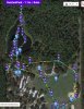
I've attached my WP mission in the txt file. I'd love for someone more experienced to take a look at it in their Mission Hub and see if they have any recommendations (other than to walk the area to see if there are any other obstacles I couldn't see on the map) or concerns.
Attachments
- Joined
- Oct 16, 2015
- Messages
- 548
- Reaction score
- 123
- Age
- 60
I don't know if the CVS export shares all the information, but is it true you are flying a large part of the mission backwards?I've attached my WP mission in the txt file. I'd love for someone more experienced to take a look at it in their Mission Hub and see if they have any recommendations (other than to walk the area to see if there are any other obstacles I couldn't see on the map) or concerns.
You don't have any POI's. What is the reason behind the orientation?
You have two actions (wp 1,8: wait 5 sec). You are flying straight lines ? With curved turns you cannot use actions.
Above the pond you are flying at 5m. This is quite low. I would check/try that out first. This is also true above the grass.
- Joined
- Oct 16, 2015
- Messages
- 548
- Reaction score
- 123
- Age
- 60
Good Points!Have been using Litchi for about a month now with terrific results. Here's a few things I've learned.
1 On a Litchi flight plan the drone will often be flying sideways. The obstacle avoidance only works for obstacles facing the 'front' of the drone - for many Litchi flights you will have no obstacle avoidance
2 This makes it very important you 'eyeball' the flight path and not depend on the satellite imagery provided by Litchi
3 If the drone becomes disconnected because of poor signal strength it will complete the flight
4 Practice small flight paths first, by small I mean you retain visual contact with the drone
5 Give yourself plenty of vertical room - if you're not sure of the height of an object (building, tree, bridge) fly to it manually, check the height and add 10m
6 Make sure you understand the difference between elevation and altitude and how to fly over terrain which varies in elevation
7 Double check your RTH altitude in relation to the terrain you're flying in
This is a link to my first Litchi flight. I love the app but have had a couple of near misses because all due to pilot error
Some more points:
You can explore the mission path manually and then store the waypoint using the C1 button of the RC (or POI with C2).
Check the heights of the wps and check the speed. Try the mission the first time using a modest speed.
If needed you can pause the mission using the pause button on the screen or the play button of the RC (lowest button, right side).
Thanks everyone! @rene van der meer , yes I am flying a great distance away, backwards, focusing on where me and my party will be hanging out. Not sure why my POIs are not showing up for you because that might have explained why I was facing some of the directions I was facing. I am flying many straight paths, but I have strong curves implemented as well. I do not really start looking forward when I'm flying until I hit WP 23. I'll do some separate orbit shots outside of the mission and then sprinkle them in to the final video.
Attachments
- Joined
- Jan 2, 2017
- Messages
- 610
- Reaction score
- 303
- Age
- 64
Actually, no. POIs are usually ground features, so you want the camera framed on the object of interest, right?Not sure why but in the mission hub for Litchi the height defaults to 3 feet for a POI. That's crazy too low.
Actually, I think its 3m (10') actually. In any case, this is about right most of the time.
- Joined
- Mar 6, 2017
- Messages
- 317
- Reaction score
- 28
- Age
- 66
I'm not that experienced but I noticed you didn't make a rookie mistake by adding your last waypoint in side the fence from home not much room there. Out side is good the fence not too far away from . HOME AND NOT TOO CLOSE TOAlso the last waypoint is far enough away from the street. I see you also dropped the altitude to 90 feet after WP4 heading towards 5 because you have a POI between 4 and 5. That's quite house/mansion? Whatever it is, if there is a pause button to set for let's say 10 seconds that would be great. I heard that there might be somewhere in Litchi.I've attached my WP mission in the txt file. I'd love for someone more experienced to take a look at it in their Mission Hub and see if they have any recommendations (other than to walk the area to see if there are any other obstacles I couldn't see on the map) or concerns.
Actually, no. POIs are usually ground features, so you want the camera framed on the object of interest, right?
Actually, I think its 3m (10') actually. In any case, this is about right most of the time.
Yes, you are correct, thanks.
- Joined
- Oct 16, 2015
- Messages
- 548
- Reaction score
- 123
- Age
- 60
JxBx80 it seems that Litchi does not export POIs. I tried exporting a mission and reloading it.Thanks everyone! @rene van der meer , yes I am flying a great distance away, backwards, focusing on where me and my party will be hanging out. Not sure why my POIs are not showing up for you because that might have explained why I was facing some of the directions I was facing. I am flying many straight paths, but I have strong curves implemented as well. I do not really start looking forward when I'm flying until I hit WP 23. I'll do some separate orbit shots outside of the mission and then sprinkle them in to the final video.
Also the Mission hub and the App show different orientations.
- Joined
- Feb 2, 2017
- Messages
- 134
- Reaction score
- 46
Has anyone had any luck flying the P4 with Litchi on a Nexus 7 II? So far, all I get is "failure to connect to DJI servers" message, and litchi blames it on DJI. DJI, of course, does not respond.
Once you've got everything connected and on - unplug the cable to the Nexus and replug it in. Works for me every time.
Im sure its a simple setting in the Nexus (USB) but I haven't taken the time to figure it out.
Also, make sure "the other" program is not active.
Similar threads
- Replies
- 39
- Views
- 1K
- Replies
- 6
- Views
- 6K
- Replies
- 5
- Views
- 2K
- Replies
- 6
- Views
- 614


Recent Posts
-

-
 North Jersey, Very new old guy trying to get off the ground with a P330Z Phantom 2
- Latest: captainmilehigh
-
-

-
