

- Joined
- Feb 6, 2018
- Messages
- 63
- Reaction score
- 32
- Age
- 48
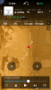
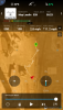
Hey Everyone! I know, it's another post asking for your help to figure out why a drone crashed. Maybe the slight difference is I have a decent amount of experience under my belt so this isn't your typical first flight gone wrong type of post. The short version of the story is I took off, flew straight up to an altitude of 30 ft and a few seconds later, without touching the sticks, the drone flew forward on its own, crashing into a building (and then to the ground). I've attached a few files that may help decipher what happened. The "flight midpoint" screenshot was from right before the drone took off on its own. The "flight end" is the last recorded info. The "GPS Signal Weak" notification only appeared on that very last frame. The weird thing is the flightpath shows a very wonky path whereas in real life, the drone only flew up (under my power) and then forward (on its own).
Now for the longer version of the story:
I was hired to shoot some new civic center buildings which consists of two long buildings with a courtyard between them. I started with a homepoint across the street and got several passes through the courtyard (where my drone would later crash). A battery and a half later, I brought the drone inside the courtyard and powered it up. I got a compass error for a brief second and was about to calibrate it but the warning went away and all the criteria looked good for taking off. My new homepoint was recorded, I had enough satellites and took off, flying up 30 ft. A few seconds later the drone flew forward on its own. In my panic, I pulled down on my left stick and in doing so, caused the drone to rotate 150 degrees which I saw it do before hitting the building. According to my flight logs, I pulled up on my left stick (not down) which is why it climbed to 60 ft before crashing. My Visual Observer also said it looked like the drone crashed from 60 ft up.
Replaying the crash in my head, I was positive that I pulled down on my left stick and realized what I should have done was pull down on my right stick and switched the remote from P to A mode. Unfortunately, I only had a couple seconds to react.
Even if I'm completely wrong and I really did pull up on my left stick, it doesn't explain why the drone flew forward on its own (you can see in the logs the sticks aren't being touched when it flies away from me) and why the recorded flightpath is all over the place when it only flew up and then forward.
A couple hours later I had my back-up drone in the air (launching from homepoints away from the crash site) and ran into several compass and lack of satellite errors. I know that there is a lot of RF in dense downtowns (and who knows what underground) plus blockage from all the tall buildings. I kept picking up and trying to find new places I could launch from (and recalibrated my compass often).
As mentioned, I've flown well over 100 hours and I've never had a drone take off on its own before. I've also flown in similar type areas where interference is occasionally a problem but never caused a flyaway. This is scary stuff if things like this still happens with the newer drones. Thank goodness I insisted on doing this flight early on a Sunday morning when no one would be around.
Some other side notes: One block away was a prison which the DJI app wouldn't let me fly over when I was at a higher altitude. Yet this was the direction my drone headed on its own.
And if anyone was wondering, yes, I'm Part 107 certified (since the first day it was offered), I have liability (but not hull) insurance, I had airspace authorization and even the Chief of Police was aware of my flight that happening that morning. The drone was less than 6 months old. I've flown with a P3P the previous 3+ years.
My biggest question is, "Why did the drone fly away on its own?" with the follow up, "What could I have done differently?"
Thank you in advance for your help!
Mark


") If that hurts too much you could try retrieving the .DAT from the tablet.
If that hurts too much you could try retrieving the .DAT from the tablet.


