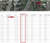
Can someone explain to me how I'm flying underground in this flight? Note the arrow on the satellite view shows the location of the arrow/data on the statistic.
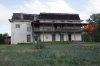
This was flown at the historic Mills Mansion - ABOVE GROUND - in Springer, New Mexico.
I've been getting some pretty flaky reports from my flight logs, showing outrageous [and untrue] distances and altitudes since my controller was replaced with a GL-300-C.
Any ideas on what's going on here? Compass was calibrated at the home point before flight.