CAPE HATTERAS; Barrier islands of North Carolina Drone Footage Wanted !

Joined
Feb 3, 2021
Messages
16
Reaction score
7
Location
France
Website
www.hosiho.com
Dear Drone Pilots,

As an Aerial & Drone Stock Agency, we often receive from our clients a list of images they really need urgently.

Here’s the latest one received, so if you might have the right shot on file, it could lead to a quick sale.

Just let me know if you have it, and I’ll give you guidance to join our 200+ HOsiHO contributors.

You can also follow those requests live on our Facebook group.

Thanks and have a great day.

Drone Stock Footage Requested by our client - #266 : USA - CAPE HATTERAS; Barrier islands of North Carolina

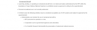
Client Brief: looking for beauty shots, aerials and establishing shots of modern day CAPE HATTERAS and the barrier islands of North Carolina for a TV doc series.


Type of project : US TV Doc Series

Deadline : April 17th, 2021​
 
  • Like
Reactions: MTO
That is within the National Seashore...off limits
Thanks for the info, maybe with a permit or a waiver someone was allowed to flyover there?
 
Possibly a movie company...I don't think it is possible for a private individual
 
There are areas on the islands that are not part of the National Park where you can launch and land. There is no issue with overflight of National Park lands. This could also be accomplished by launching from a watercraft.
 
There are areas on the islands that are not part of the National Park where you can launch and land. There is no issue with overflight of National Park lands. This could also be accomplished by launching from a watercraft.
Anything on Hatteras Island south including Okracoke Island is within the park ...70 miles
1618571662217.png
..I had trouble metal detecting down there and almost had my equipment confiscated.....same regs apply to drones...what I posted can be found here:
Laws & Policies - Cape Hatteras National Seashore (U.S. National Park Service) believe me...I would love to use mine there....but they are pretty adamant...and I believe that their authority does extend into the water....but with worthy watercraft...you could possibly get out past their boundary....not trying to be a kill joy.....but I would not want anyone to have equipment confiscated
 

Attachments

  • 1618571491095.png
    1618571491095.png
    23 KB · Views: 170
The areas you cannot launch and land are in red which are the boundaries of the National Park. You can see from the screenshots that both B4UFLY and AirMap show the same boundaries. There is water on either side of the islands that is not park property nor special use airspace (military).

Park officials may frown on drone use, but we also have the right to fly there by FAA regs. This would be a 107 operation at any rate. If I were doing this I would contact the park service and inform them of my intentions and my flight plans. 1C16037F-C673-495E-B0E2-F04E8EFEA87B.jpegC661C63F-C997-4CD1-8859-0E74F2C75337.jpeg
 
  • Like
Reactions: Mark The Droner
I go down there every year and have gotten some great photos...there are a lot of attractions that would make for fantastic videos....the Sound with people wind surfing, guys with regular boards in the surf...light houses, fishing piers, marshes.....some terrific targets...the place I stay does have row boats available....sounds like it is just a matter of having a competent assistant and a way to keep the equipment from getting wet...I go down every August...look for my videos before the end of that month:cool:...thanks for the info @DoomMeister
 

Recent Posts

Members online

Forum statistics

Threads
143,066
Messages
1,467,357
Members
104,935
Latest member
Pauos31