- Joined
- Dec 24, 2015
- Messages
- 10
- Reaction score
- 0
- Age
- 55
P3 flight / FAA compliance question:
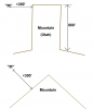
I drove 400 feet up the side of a steep mountain on the Wasatch Front. Mountains run generally from South to North and I was on the West side.
I launched my drone and went to a height (from my position) of 200 ft.
Then I flew my drone to the West, away from the mountain . . . such that the ground dropped away from the drone due to the mountain slope.
Very quickly, the distance to ground increased to 600 ft. At this point, have I violated FAA rules?
The, I flew back toward the mountain, and then northward over ridges and valleys. During that time, the distance to ground varied with terrain changes (at times much below 400 feet, and at other times much above). There was no accurate way for me to assess the distance.
In general, gave I violated FAA rules?
If so, then how do I comply in such a situation?
If the above scenario does violate FAA guidelines, then aren't those guidelines just a bit like highway speed limits? I mean . . . who in their life has never exceeded the speed limit by at least 1 mph?
Last edited: