
Hi pilots- I'm sure most of you have seen this video already, but in case you haven't, I just came across this video Todd Copeland put together on the Way points procedure and the rationale behind it. Definitely worth a look.


You are using an out of date browser. It may not display this or other websites correctly.
You should upgrade or use an alternative browser.
You should upgrade or use an alternative browser.
Way Points Tutorial Video
- Thread starter Dounin Front
- Start date

- Joined
- Jun 1, 2015
- Messages
- 302
- Reaction score
- 183
- Age
- 58
All good, I might be a bit pedantic but if you are going to use phonetics, use the correct terminology. P is not "Paul" mode, it's "Papa" and F is not "Frank" it's "Foxtrot". Now I feel better getting that off my chest.
- Joined
- Jun 1, 2015
- Messages
- 302
- Reaction score
- 183
- Age
- 58
May be isolated to me but video has no sound. Other videos have had sound today on my phone. Thanks for the post. I hope to hear it.
- Joined
- Oct 8, 2015
- Messages
- 66
- Reaction score
- 22
- Age
- 51
Maybe I missed it but the altitude listed on the waypoints were not the altitude the bird was flying at. He addressed it earlier that when he was marking the waypoints there was a difference in what the waypoint altitude was saying at the actual bird altitude. It appears that during the flight, it flew the altitude that the bird was actually flying not what was listed on the waypoint.
Excellent video though.
Excellent video though.
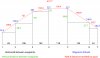
The measurement shown by the waypoint on the map is the horizontal distance between waypoints. The distance on the right hand side is the actual distance travelled by the quad, calculated using Pythagorus with the horizontal distance between waypoints and the difference in altitudes between waypoints.
- Joined
- Oct 8, 2015
- Messages
- 66
- Reaction score
- 22
- Age
- 51
Makes sense it looked like the author was trying to point out the feet displayed didn't correspond to the altitude of the bird, which he initially spoke to, but I didn't hear him address it after that. Thanks.
Maybe I missed it but the altitude listed on the waypoints were not the altitude the bird was flying at. He addressed it earlier that when he was marking the waypoints there was a difference in what the waypoint altitude was saying at the actual bird altitude. It appears that during the flight, it flew the altitude that the bird was actually flying not what was listed on the waypoint.
Excellent video though.
I think he was wrong when he kept referring to the altitude shown on the app. I believe it was instead the distance between waypoints. That's why there is no number on waypoint #1. It looks like there is no permanent indicator of the drone's altitude at each waypoint, you only see it in the real time gauges at the bottom. It does remember the waypoint altitudes however for your mission flight.
I especially liked his demo of possibilities at 12 minutes in and beyond.
Great video! I can't speak for anyone else but I seem to always pick up something new
Altitude is always vs the point I took off right? I would love to see an app that would also show the true altitude side by side. I have lots of foothills in my area and I think it would be really useful. Would it be difficult to incorporate? Would anyone else find it useful?
Thanks for posting the link to this. Love to see more!
Great video! I can't speak for anyone else but I seem to always pick up something new
Altitude is always vs the point I took off right? I would love to see an app that would also show the true altitude side by side. I have lots of foothills in my area and I think it would be really useful. Would it be difficult to incorporate? Would anyone else find it useful?
Thanks for posting the link to this. Love to see more!
Dji may have determined it was too much information and too little real estate to show it. I live in the RM front range so I add 6000 ft to the altitude. Yesterday my takeoff point was 7000 ft.
Get the "Altimeter" app for your iPhone to know your height above sea level at takeoff.
Maybe TMI for some that don't have much altitude change. I can understand that
I do have that app and I'm about 425 feet above sea level There is a few maps I can search and get exact altitude but would sure be nice to see it live! Just a wish I guess. Maybe in a future upgrade
Thanks again for the video.
I do have that app and I'm about 425 feet above sea level There is a few maps I can search and get exact altitude but would sure be nice to see it live! Just a wish I guess. Maybe in a future upgrade
Thanks again for the video.
Yes I think about it too. FYI: Google "Earth" shows elevation as you mouse around. It's great. Dji app would be better yet.Maybe TMI for some that don't have much altitude change. I can understand that
I do have that app and I'm about 425 feet above sea level There is a few maps I can search and get exact altitude but would sure be nice to see it live! Just a wish I guess. Maybe in a future upgrade
Thanks again for the video.
All good, I might be a bit pedantic but if you are going to use phonetics, use the correct terminology. P is not "Paul" mode, it's "Papa" and F is not "Frank" it's "Foxtrot". Now I feel better getting that off my chest.
If you are using the LAPD phonetic alphabet, then it is Paul and Frank. There are many phonetic alphabets in use around the world other than the NATO one.
LAPD radio alphabet - Wikipedia, the free encyclopedia
The measurement shown by the waypoint on the map is the horizontal distance between waypoints. The distance on the right hand side is the actual distance travelled by the quad, calculated using Pythagorus with the horizontal distance between waypoints and the difference in altitudes between waypoints.
I don't see this as being correct if I understand your post. For example:
Waypoint 1 was set at 75 feet high. Waypoint 2 was set at 132 feet high. This is a difference of 57 feet. However, waypoint 2 shows "82 feet".
Also, I can't think of any good reason why someone would need to know the difference in height between two waypoints. All other possibilities would be far more useful.
When you say "horizontal distance" I'm assuming this means the difference in height from one waypoint to another.
Also, the measurement is the not the actual distance of a straight line from waypoint to waypoint. If the straight line distance from waypoint 1 to waypoint 2 were 82 feet (as reported) then the flat distance (for example, on the ground) would be 60 feet. This if different than the 100 feet reported in the pop up window.
I think he was wrong when he kept referring to the altitude shown on the app. I believe it was instead the distance between waypoints. That's why there is no number on waypoint #1. It looks like there is no permanent indicator of the drone's altitude at each waypoint, you only see it in the real time gauges at the bottom. It does remember the waypoint altitudes however for your mission flight.
I especially liked his demo of possibilities at 12 minutes in and beyond.
It's not the distance between waypoints either. I do give a breakdown in a reply to a comment. Those numbers don't add up.
Thank you for your initial post and this one. It really warms my heart to hear such feedback. I _really_ enjoy making these videos and I know I'm terrible at them. So to hear some positive feedback is a great reward.
Altitude is always vs the point I took off right? I would love to see an app that would also show the true altitude side by side. I have lots of foothills in my area and I think it would be really useful. Would it be difficult to incorporate? Would anyone else find it useful?
I don't know of any current hardware that would allow the Phantom to know the change in the level of the ground under it if the Phantom is more then 10 feet high. Under 10' and the ultrasonics will work and _help_ keep the Phantom level with the change in the ground. But it's not as quick as the Phantom can fly so it should not be relied upon.
I don't know of any current hardware that would allow the Phantom to know the change in the level of the ground under it if the Phantom is more then 10 feet high. Under 10' and the ultrasonics will work and _help_ keep the Phantom level with the change in the ground. But it's not as quick as the Phantom can fly so it should not be relied upon.
I agree with that. I thought the question was knowing the elevation above sea level. Google Earth does a good job of pinpointing elevation on their topographical map, but it certainly wouldn't help with buildings, objects and obstructions. Radar is what we need, but there goes another $1000.
What is use of waypoints if you have to fly the route first?
I am not being a cynic I really want to know how you guys are using it and why?
It seems to me the entire point of waypoints is to not have to fly the route right?
I am not being a cynic I really want to know how you guys are using it and why?
It seems to me the entire point of waypoints is to not have to fly the route right?
I don't see this as being correct if I understand your post. For example:
Waypoint 1 was set at 75 feet high. Waypoint 2 was set at 132 feet high. This is a difference of 57 feet. However, waypoint 2 shows "82 feet".
Also, I can't think of any good reason why someone would need to know the difference in height between two waypoints. All other possibilities would be far more useful.
When you say "horizontal distance" I'm assuming this means the difference in height from one waypoint to another.
Also, the measurement is the not the actual distance of a straight line from waypoint to waypoint. If the straight line distance from waypoint 1 to waypoint 2 were 82 feet (as reported) then the flat distance (for example, on the ground) would be 60 feet. This if different than the 100 feet reported in the pop up window.
I've (hopefully) attached an image showing the vertical and horizontal differences between waypoints, the horizontal difference matching the figure shown on screen from waypoint 2 onwards, and the distance the quad travels between waypoints, which corresponds to the distance shown on the right of the screen.
Attachments
I agree with that. I thought the question was knowing the elevation above sea level. Google Earth does a good job of pinpointing elevation on their topographical map, but it certainly wouldn't help with buildings, objects and obstructions. Radar is what we need, but there goes another $1000.
A person would also at least need to have an active data connection while flying. This would be a minimum requirement. I think this would be too limiting in use fro DJI to make it possible at this time.
I have no doubt that we _are_ going to see some better obstacle avoidance capability in the near future.
Similar threads
- Replies
- 14
- Views
- 2K
- Replies
- 9
- Views
- 2K
- Replies
- 7
- Views
- 2K
- Replies
- 1
- Views
- 2K


