Phantom 2 + GoPro Mapping?

Joined
Mar 1, 2014
Messages
137
Reaction score
0
Location
San Francisco
Has anyone figured out a way to use the Phantom 2 (non vision or vision+) to map locations and turn them into 3d objects?

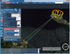
I was looking recently at http://pix4d.com/pix4d-releases-app-dji-phantom-vision/ also read this post at DIY Drones http://diydrones.com/profiles/blogs/creating-3d-models-using-pix4d-ugcs-and-dji-phantom-2 which uses this software as well http://www.ugcs.com/

Anyone figured out the best way to do this with the non vision phantoms ?

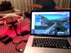
I have 2 Phantom 2's with 2 gopro's and I just got a the gopro 4 which ill be testing today. I have iPad ground station as well
 
I have used autodesks 123D Catch with some success.
 
I reached out to both Pix4d and UgCS, and got a reply from the UgCS folks.. here is what they wrote.

As you have Phantom 2 and DJI Data Link (I saw this all on footage), you can use our software with Phantom.

You need these simple steps

- register on our site (ugcs.com)

- download Open version

- install it on computer (PC or MAC)

- download and install from DJI's site Phantom drivers for PC - if you will use Windows notebook.

- run UgCS

- connect DJI Data Link to USB port of computer, and UgCS should recognize your phantom (Phantom should be powered on too)

- and you can plan missions and fly.
 
Btw I was able to get this working on my mac, I had to reboot to get it to see the phantom. I watched the webinar they have on flight paths, this gives you a bit more flexibility over the iPad ground station since it doesn't help you with elevation. Of course where I live I also have to take into account the tree heights.


Next step is to do a test flight in a local hiking area thats flat, and after that turning that data into a 3d modle. I looked at Pix4D but they do not offer any mac software and well its super expensive to use, so I found an alternative method using Autodesk ReCap

[youtube]http://youtu.be/mgYQoFYH0V8?list=PLQOxJKbIe-77Y-1pLHsxOOM6IEJ6vVXUv[/youtube]

Or might test 123D catch first as their free 3d model creator with limitations but should give me a good idea of what could be done if I use their pro version.

After I get all the issues resolved I'm going to refly my flight plan from Emerald Bay [youtube]https://www.youtube.com/watch?v=x4IFEZu5wtQ[/youtube]

Links:

* UgCS Videos https://www.youtube.com/playlist?list=PLRfRuRLHgAaWRJLLbUY7OUJg0LwZEKgtJ
* Autodesk ReCap Webinar http://youtu.be/mgYQoFYH0V8?list=PLQOxJKbIe-77Y-1pLHsxOOM6IEJ6vVXUv
* 123D Catch http://www.123dapp.com/catch
* ReCap 360 online https://recap360.autodesk.com/Signin.aspx
 

Attachments

  • UgCS.jpg
    UgCS.jpg
    256.2 KB · Views: 1,313
ADobrovolskiy said:
Hi guys,

if anyone wants to try UgCS (ugcs.com) and will meet any difficulties don't hesitate to ask me.

Here http://ugcs.com/discover we have manual how to connect Phantom (WKM, A2) to UgCS.

Thanks for joining. One thing us Phantom Pilots have been wanting that the ground station doesn't seem to do is a look at or focus point. So for example if you have a circle flight path you only get the ability to view the path you take, lets say you wanted to do a circle and focus the camera on the center of the circle so your rotating around an object, is this possible iwth UgCS? If so how?
 
UgCS can't do what autopilot can't do. So if Phantom can fly en-route only with nose toward next waypoint we can't instruct it do something different.

If you want to make still photos there is some workaround with help of UgCS. You can draw Circle around point of interest and setup two actions - Change Yaw to 90 degrees right and Wait 10 seconds. Phantom will arrive to waypoint, turn right and wait. Your GoPro will have enough time to make some good photos...

Sample of this route:
 

Attachments

  • Emerald Bay Route.png
    Emerald Bay Route.png
    1.3 MB · Views: 1,183
ADobrovolskiy said:
UgCS can't do what autopilot can't do. So if Phantom can fly en-route only with nose toward next waypoint we can't instruct it do something different.

If you want to make still photos there is some workaround with help of UgCS. You can draw Circle around point of interest and setup two actions - Change Yaw to 90 degrees right and Wait 10 seconds. Phantom will arrive to waypoint, turn right and wait. Your GoPro will have enough time to make some good photos...

Sample of this route:

Ok thanks, will give it a shot. :)
 
I'm quite interested in trying the UGCS app but not on a Phantom -- although I use the iPad GS on a Phantom 1.0 I also have a QuadH20 with NAZA M V-2.

I'm not clear about the hardware requirements for the NAZA M. Do I need the DJI "Air Module" on my QH2o or is just the Ground Module sufficient to communicate between the quad and the UGCS app on my MacBook Pro?

thanks!
 
Hi, you need Air Module on quad connected to Naza-M V2 and Ground Module connected to your MacBook Pro.
 
ADobrovolskiy said:
Hi, you need Air Module on quad connected to Naza-M V2 and Ground Module connected to your MacBook Pro.

Thanks... I was afraid that would be your answer. I was hoping to avoid using the Air Module as mounting it would require drilling holes in the quad's waterproof hull.

Another question: will I also be limited to the DJI Ground Station's 16 waypoints?
 
Hey guys, been busy the last few days, I hope to take the Phantom 2 out in my area before we get a bit winter storm. I have been studying both the ground software UgCS and looking at the autodesk stuff, and hope to have some flights and posts about my results soon here and on my blog.
 
GearLoose said:
Another question: will I also be limited to the DJI Ground Station's 16 waypoints?

Hi, it's autopilot limit. Ground station doesn't limit waypoints. In case of NAZA-M V2 (or Phantom 2) limit is 16 waypoints, in case of WKM/A2 - 50 waypoints.
 
I've installed the UCGS software on my MacBook Pro OSX 10.9 and get an error message just as the installation is about to finish: "Error in XMLfileset action". After that, the program will not open. I tried restarting the computer and reinstalling the software -- same problem.
 
GearLoose said:
I've installed the UCGS software on my MacBook Pro OSX 10.9 and get an error message just as the installation is about to finish: "Error in XMLfileset action". After that, the program will not open. I tried restarting the computer and reinstalling the software -- same problem.

I didnt have an issue, did you install the beta patch as well? Also what drone are you using?
 
GearLoose said:
I've installed the UCGS software on my MacBook Pro OSX 10.9 and get an error message just as the installation is about to finish: "Error in XMLfileset action". After that, the program will not open. I tried restarting the computer and reinstalling the software -- same problem.

Hi GearLoose

could you send me file UgCS-installation.log

from folder ~/Library/Logs
 
I've tried again with the beta version and have the same problem, the same error message. Also, there is no installation log in the Library/Log folder. I searched the computer for "UgCS-installation.log" and get nothing.

stevet: I have a Phantom 1.5 and a quad with NAZA 2.
 

Recent Posts

Members online

No members online now.

Forum statistics

Threads
143,109
Messages
1,467,706
Members
104,999
Latest member
intertronixlabel