Hi SarFlyer,
You may be either very pleased, pr perhaps slightly depressed by an expanded exposure to some of the other [EXIF] data stored with each click of the sDJI shutter [
P4P in this example]'
You can download the excellent
ExifTool program which is available for download at
ExifTool by Phil Harvey
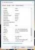
Attached is an image, and the ExitTool extracted data. It was
taken with the drone at about 75 meters above take-off point, which in turn, is perhaps about
(3-4 meters Sea level).
Exif data is extracted below.
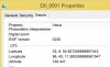
You will notice TWO areas of info pertaining to Altitude, with the "Relative Altitude" giving the 'Above take-off' height [75.3m]. GPS Altitude
Just below it is the "Absolute Altitude" [37.371m], which in this case is absolute rubbish, if you are expecting any reference to Sea-Level. (79m would be more correct)
It is interesting to note that a Windows Program called 'Advanced Renamer' allows the batch renaming of images based on many of the available fields, so for instance you could rename a image with date, GPS Location, etc.
Try it on some of your images, and look at the numbers. I am sure it will help'
Best Wishes
p.s. Place the Exif Tool on the desktop, and rename it "exiftool(-a -u -g1 -w txt).exe" (no quotes, spacing exactly as is). Then Drag and drop a file on top of it, and a text file will be credted with all the Exif Data as below.
==============================================
EXIF Data Follows
==============================================
---- ExifTool ----
ExifTool Version Number : 10.68
Warning : [minor] Possibly incorrect maker notes offsets (fix by 1783?)
---- System ----
File Name : 2018-01-17 PortMacq 286_
[31.3 m Above Sea Level],(+75.30m Rel).JPG
Directory : P:/2018-Q1/2018-01-17 DJI PortMacq ForSale
File Size : 8.6 MB
File Modification Date/Time : 2018:01:17 15:28:15+11:00
File Access Date/Time : 2018:01:17 15:10:03+11:00
File Creation Date/Time : 2018:01:17 15:10:03+11:00
File Permissions : rw-rw-rw-
---- File ----
File Type : JPEG
File Type Extension : jpg
MIME Type : image/jpeg
Exif Byte Order : Little-endian (Intel, II)
Image Width : 5472
Image Height : 3648
Encoding Process : Baseline DCT, Huffman coding
Bits Per Sample : 8
Color Components : 3
Y Cb Cr Sub Sampling : YCbCr4:2:2 (2 1)
---- IFD0 ----
Image Description : DCIM\100MEDIA\DJI_0286.JPG
Make : DJI
Camera Model Name : FC6310
Orientation : Horizontal (normal)
X Resolution : 72
Y Resolution : 72
Resolution Unit : inches
Software : v01.05.1577
Modify Date : 2018:01:17 15:28:14
Y Cb Cr Positioning : Centered
XP Comment : Type=N, Mode=P, DE=None
XP Keywords : v01.05.1577;1.1.6;v1.0.0
---- ExifIFD ----
Exposure Time : 1/200
F Number : 4.5
Exposure Program : Program AE
ISO : 100
Exif Version : 0230
Date/Time Original : 2018:01:17 15:28:14
Create Date : 2018:01:17 15:28:14
Components Configuration : -, Cr, Cb, Y
Compressed Bits Per Pixel : 3.492772616
Shutter Speed Value : 1/200
Aperture Value : 4.5
Exposure Compensation : 0
Max Aperture Value : 2.8
Subject Distance : 0 m
Metering Mode : Center-weighted average
Light Source : Unknown
Flash : No flash function
Focal Length : 8.8 mm
Flashpix Version : 0010
Color Space : sRGB
Exif Image Width : 5472
Exif Image Height : 3648
Exposure Index : undef
File Source : Digital Camera
Scene Type : Directly photographed
Custom Rendered : Normal
Exposure Mode : Auto
White Balance : Auto
Digital Zoom Ratio : undef
Focal Length In 35mm Format : 24 mm
Scene Capture Type : Standard
Gain Control : None
Contrast : Normal
Saturation : Normal
Sharpness : Normal
Subject Distance Range : Unknown
Serial Number : d3ae
---- DJI ----
Make : DJI
DJI 0x0002 : 1 2 0 0
Speed X : +0.10
Speed Y : +0.10
Speed Z : +0.00
Pitch : +9.10
Yaw : +53.50
Roll : +9.00
Camera Pitch : -17.70
Camera Yaw : +51.30
Camera Roll : +0.00
DJI 0x000c : 1.50463402461595e-036 9.29110734889936e-035
DJI 0x000d : 2684354560 262151 808452096 2684432433
DJI 0x000e : 0
DJI 0x000f : 0
DJI 0x0010 : 38
DJI 0x0011 : 0
DJI 0x0012 : 0
DJI 0x0013 : 65539 65536 -1610481664 65540 358612992
DJI 0x0014 : 2684551168 65540 239075328
DJI 0x0017 : 1
DJI 0x0019 : 64
DJI 0x001a : 13
DJI 0x001b : 0
DJI 0x001c : 124
DJI 0x001d : 123
DJI 0x001e : 12.09375
DJI 0x001f : 0
DJI 0x0020 : 0
DJI 0x0021 : 0
DJI 0x0022 : 0
DJI 0x0023 : 0
DJI 0x0024 : 0 0 5 160 4 0 1 0 0 0 144 2 0 0 21 162 5 0 1 0 0 0 247 [...]
---- InteropIFD ----
Interoperability Index : R98 - DCF basic file (sRGB)
Interoperability Version : 0100
---- GPS ----
GPS Version ID : 2.3.0.0
GPS Latitude Ref : South
GPS Latitude : 31 deg 25' 55.75"
GPS Longitude Ref : East
GPS Longitude : 152 deg 54' 7.84"
GPS Altitude Ref : Above Sea Level
GPS Altitude : 31.371 m <<<<<<
---- IFD1 ----
Compression : JPEG (old-style)
X Resolution : 72
Y Resolution : 72
Resolution Unit : inches
Thumbnail Offset : 3072
Thumbnail Length : 10759
Thumbnail Image : (Binary data 10759 bytes, use -b option to extract)
---- XMP-rdf ----
About : DJI Meta Data
---- XMP-xmp ----
Modify Date : 2018:01:17
Create Date : 2018:01:17
---- XMP-tiff ----
Make : DJI
Camera Model Name : FC6310
---- XMP-dc ----
Format : image/jpg
---- XMP-drone-dji ----
Absolute Altitude : +31.37 <<<<<<<<<
Relative Altitude : +75.30 <<<<<<<<<
Gimbal Roll Degree : +0.00
Gimbal Yaw Degree : +51.30
Gimbal Pitch Degree : -17.70
Flight Roll Degree : +9.00
Flight Yaw Degree : +53.50
Flight Pitch Degree : +9.10
Cam Reverse : 0
Gimbal Reverse : 0
Self Data : Undefined
---- XMP-crs ----
Version : 7.0
Has Settings : False
Has Crop : False
Already Applied : False
---- MPF0 ----
MPF Version : 0010
Number Of Images : 2
Image UID List : (Binary data 66 bytes, use -b option to extract)
Total Frames : 1
---- MPImage1 ----
MP Image Flags : Representative image, Dependent parent image
MP Image Format : JPEG
MP Image Type : Baseline MP Primary Image
MP Image Length : 8737445
MP Image Start : 0
Dependent Image 1 Entry Number : 0
Dependent Image 2 Entry Number : 2
---- MPImage2 ----
MP Image Flags : Dependent child image
MP Image Format : JPEG
MP Image Type : Large Thumbnail (VGA equivalent)
MP Image Length : 244754
MP Image Start : 8737445
Dependent Image 1 Entry Number : 0
Dependent Image 2 Entry Number : 0
Preview Image : (Binary data 244754 bytes, use -b option to extract)
---- Composite ----
Aperture : 4.5
GPS Altitude : 31.3 m Above Sea Level
GPS Latitude : 31 deg 25' 55.75" S
GPS Longitude : 152 deg 54' 7.84" E
GPS Position : 31 deg 25' 55.75" S, 152 deg 54' 7.84" E
Image Size : 5472x3648
Megapixels : 20.0
Scale Factor To 35 mm Equivalent: 2.7
Shutter Speed : 1/200
Circle Of Confusion : 0.011 mm
Field Of View : 73.7 deg
Focal Length : 8.8 mm (35 mm equivalent: 24.0 mm)
Hyperfocal Distance : 1.56 m
Light Value : 12.0
========================================
=======

![2018-01-17 PortMacq CGL 286_[31.3 m Above Sea Level [WRONG]],(+75.30m Rel to Toff).JPG](/data/attachments/90/90673-3609121635a2dc0a7e054a71074d22b6.jpg?hash=NgkSFjWi3A)


