I recently purchased my Phantom for Pro and I have already taken my first flight in a designated safe zone.
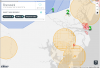
I do have a question regarding the know before you fly map, My question is I need a little clarity on what do these icons necessarily represent? Obviously I know that you cannot fly in the amber colored circles as well as in the red but what is the blue circle illustrated in this map and what's with the little tiny green circle? It would help if the map had a legend telling you what everything is, also beside the DJI Go App indicating where it's safe to fly what other application do you currently run on Android to tell you exactly where it's safe to fly?
Thanks in advance,
-Josh