Flying in National Parks

Joined
Jul 25, 2016
Messages
228
Reaction score
111
Age
67
That got your attention didn't it? :)
It actually is a question about it, and I'm looking at a Litchi flight plan but I'm curious if anyone's run into this. It is not about flying in it's about flying through a National Park. They own property on both sides of the river in a small stretch but not all on the one side. Here's the question.

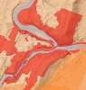
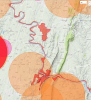
I have a National Park that has a fairly good sized river that runs by it. 3-400 yards minimum wide in some places near a 1/4 mile. Big enough to have dams and rapids.It's also on 3 state lines which makes it more interesting. None have drone laws that ban it. Now I have no problem at all with not flying in a National Park. I don't want to see a drone climbing El Capitan or over Yellowstone. What's good for one I'm good with for all. But now it gets sticky. I want to fly the river.

Now before you say no, there are also Federal laws on the books that say if your property has a navigable waterway you have to allow access If you live on the Mississippi you can't control the waterway. Not even if you own property on both sides. I can't set foot on your property - that's trespassing, But you have to allow me to traverse the river. So which wins? I'm thinking I'm legit.

I know if I call the park they'll just say "no drones" and no discussion because for the average Fed employee that's the easy way out. I know. I deal with them daily. It's where stupid often goes to die. I'm just interested in your collective thoughts. Pretend you're a judge and you have to make a guilt or innocence call.

Thanks.
 
Last edited:
Welcome CCrew.

Since NP's are prohibiting take offs & landings from within the park boundaries I would suspect they would prohibit you from doing so if they saw you or you were reported to them. The river would be within the parks boundaries if I understand you correctly.
 
CC - your idea would only make sense if the river was not within the park. In other words, park boundaries stopped at the water's edge. If so, you could perhaps wade into the river and hand launch/catch your drone and thereby technically not break any park rules. But I'd imagine those waters are part of the park.

So I agree with TJ.
 
As a point of clarification, I wouldn't need to take off nor land from the park boundaries. For those of you in the area the area I'm talking about Harpers Ferry NP, which sits on the WV/VA/MD borders, you cross all three. Companies run concessions for tubing/rafting through this park currently, and they beat the NPS by putting people in upstream of the park and pulling out downstream, (exactly what I'd be doing) so it's not without precedent.

By the same token using the "can't do it" logic the C&O Canal runs from DC to Cumberland, MD (160'ish miles) on one side of the river, which makes that entire river a no fly zone since the MD border which is where that C&O NP is extends to the shore on the other side.

Where it gets sticky IMHO is the Navigable waterways part. I'm no different than those concessions other than the fact that instead of floating I'm using that same space flying.
 
Last edited:
As an additional information point. Here's an airspace map. Note how the river isn't included in the "no fly zone" the rest are private airports on various farms that would require notification (which I'd happily do) I'm looking at flying between the two bridges on this map. On the larger scale view in the following post the red along the river is C&O Canal NP.
 

Attachments

  • Screen Shot 2016-08-06 at 11.14.41 AM.png
    Screen Shot 2016-08-06 at 11.14.41 AM.png
    884.6 KB · Views: 636
Larger scale view
 

Attachments

  • Screen Shot 2016-08-06 at 11.22.16 AM.png
    Screen Shot 2016-08-06 at 11.22.16 AM.png
    2.3 MB · Views: 493
If you are not launching or landing from within the park, then there's nothing to discuss regarding the park.
 
If you are not launching or landing from within the park, then there's nothing to discuss regarding the park.
Unless of course they think they own the airspace over the river. Judging by those maps, I read it that they don't?

Like I said, I have no problem not overflying a NP and don't care to set the precedent. This is more a subjective question as to whether that appears to be legally navigable airspace. Thanks.
 
No, they don't think they own the airspace over the river or anywhere else. They even state it in the rule, which is more than they really needed to say. I don't know how to find the actual text of the rule but this has been discussed here before. Bottom line is, you can fly over, through, and within the national park. You just can't launch and land within the park. Hope this helps.
 
Good luck making the leap on the navigability status of the water. Two bits says the park service regulates boating on that river. And good luck fighting the ticket in federal court. But send us a photo of your bird with an evidence tag attached to it. ; )

SB
 
Two bits says the park service regulates boating on that river.

Actually they tried to shut down/control the private concessions running tubing/rafting on the river and lost. So what they ended up with was the vendors buying property upstream and downstream. It was a pretty contentious battle for a while that IIRC the NP lost in a flaming fashion. .
 
Yeah I know what you're talking about. I drive past there once or twice a year. Beautiful area to fly a drone, er, Phantom.
 
My understanding is that the rivers are not but...

Some of the islands are and yes, you are surrounded by national parks. Also the bridges and damns can be considered "critical infrastructure" if you had a jackbooted government employee push it,

One inch over the MD side and you are in the C&O Canal Park.

It's a great spot and do share the photos and video, I have thought about driving up there and shooting, you could grab some spectacular shots.

Up towards Paw Paw there are some abandoned railway bridges and the river has some fantastic bends around them too.
 
Up towards Paw Paw there are some abandoned railway bridges and the river has some fantastic bends around them too.

Thanks, I almost forgot about them! They're actually already land banked as a rail trail because MD and WV wanted to extend the WMRT bike trail from where it currently ends near Pearre to Paw Paw and the intention was to use those bridges. We've biked up that way frequently.. I know they're accessible from the WV side with no restrictions other than you can't go on the bridges themselves at this point. On edit: Interestingly enough though the rail right of way is showing as NPS property, it's the narrow line on the WV side..
 

Attachments

  • Screen Shot 2016-08-08 at 5.26.29 AM.png
    Screen Shot 2016-08-08 at 5.26.29 AM.png
    837.6 KB · Views: 354
I know this makes interesting conversation and I enjoyed reading the attempts to thread through possible loopholes in the regulations, however, at some point common sense and the spirit of the regulation needs to prevail. You can't fly there. The fact that you're having to split hairs over ownership and comparing yourself to tubers should tell you its not a place for drones. The spirit of the regulations is to protect people, their "nature experience" and more importantly wildlife that will be scared thereby affected by the presence of drones.

There's no specific rule in baseball that says you can't come to bat with a tennis racquet, but you can't come to bat with a tennis racquet.

Being the strict rule follower that you are, I'm absolutely certain you will contact the airport owner whose airspace you will occupy (see below) and notify them of your intended flight including time frame and max altitudes as clearly instructed by the FAA, there's no gray area on this rule by the way.

upload_2016-8-8_8-47-58.png
 
The spirit of the regulations is to protect people, their "nature experience" and more importantly wildlife that will be scared thereby affected by the presence of drones.
Yeah, I liken it to a similar rule that says you can't hike into a National Park and locate a GeoCache, because by golly you might be hiking! I abide by that one too. Like I said in my initial response, I have no issue with their rule, but in looking at any aeronautical maps that river has no aerial restriction. Rules are at times meant to be clarified, and this one looks ambiguous

Being the strict rule follower that you are, I'm absolutely certain you will contact the airport owner whose airspace you will occupy (see below) and notify them of your intended flight including time frame and max altitudes as clearly instructed by the FAA, there's no gray area on this rule by the way.

Actually yes I would, even without some random internet snarkiness that starts a sentence with "Being the rule follower you are". I carry a security clearance and attempt to not purposefully try to have to talk to my security officer. And the funny part is that FAA map makes no mention of the CBP facility in that circle that you best not get a drone anywhere near.
 
My snarkiness was by design. You can fly wherever you want, but when you are splitting hairs and comparing your drone to tubes in a river please expect it.
Is every cubic foot of airspace accounted for in a rule book or map . . . no. That's where common sense and spirit of law come into play.
That being said, on Google Earth it looks like a great place to fly and I can see why you would want to fly there !
 
  • Like
Reactions: BigAl07
My snarkiness was by design. You can fly wherever you want, but when you are splitting hairs and comparing your drone to tubes in a river please expect it.

The analogy was used because there is existing Federal law that ensures unfettered access of a navigable waterway. The wording of the law: "
"The accepted test of navigability is whether the waters are used, or are susceptible to being used, in their ordinary condition, as highways for commerce. If the water met the navigability test at any point in its history, it remains a legally navigable waterway. Navigability does not depend on the particular mode of such actual or possible use".

Clear as mud :)

Well it is called "Harpers Ferry" for a reason. :)

I think Whites Ferry along the C&O is still active. Most of the others are long gone. It would be cool to shoot that but you'd have to shoot from the VA side only.
 

Recent Posts

Members online

No members online now.

Forum statistics

Threads
143,094
Messages
1,467,600
Members
104,980
Latest member
ozmtl