- Joined
- Jan 22, 2017
- Messages
- 17
- Reaction score
- 2
- Age
- 48
Hi ")
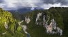
I've been trying to film and photograph in some gorges recently where there is little to no GPS at the takeoff point. When I try and go up a message comes up saying maximum flight altitude reached which seems to be about 10m up. I then fly it up and down the valley for a while until I can get GPS signal and go up (this chews up a lot of battery). After that I fly back over top of where I am and reset the home point. Once the drone is about 30m up the GPS works fine but is there any way I can just fly straight up from the takeoff point with no GPS? (i.e change the maximin flight altitude without GPS).
I've been trying to film and photograph in some gorges recently where there is little to no GPS at the takeoff point. When I try and go up a message comes up saying maximum flight altitude reached which seems to be about 10m up. I then fly it up and down the valley for a while until I can get GPS signal and go up (this chews up a lot of battery). After that I fly back over top of where I am and reset the home point. Once the drone is about 30m up the GPS works fine but is there any way I can just fly straight up from the takeoff point with no GPS? (i.e change the maximin flight altitude without GPS).

")