Please i have a client who has interest in mapping, surveying and fly through animation for a state EXPO, something like DUBAI EXPO 2020, he knows the maximum height for drone regulations is 400ft but he wants to know what the PHANTOM 4proV2.0 will capture at that height in terms of hectares of land or square metres etc


You are using an out of date browser. It may not display this or other websites correctly.
You should upgrade or use an alternative browser.
You should upgrade or use an alternative browser.

Meta4
Premium Pilot
- Joined
- Jan 8, 2014
- Messages
- 15,388
- Reaction score
- 9,341
At 122 metres the Phantom 4 pro camera (shooting 3:2) would cover an area on the ground of 183 metres x 122 metres.Please i have a client who has interest in mapping, surveying and fly through animation for a state EXPO, something like DUBAI EXPO 2020, he knows the maximum height for drone regulations is 400ft but he wants to know what the PHANTOM 4proV2.0 will capture at that height in terms of hectares of land or square metres etc
That's 22326 square metres or 2.23 hectares
But by using a mapping app, you can create an orthophoto for much larger areas while staying at or below 400 ft.
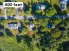
Here's an example of a highly detailed orthophoto of a 13 ha site, shot from less than 400 ft.

You know your math and showed it can be done. Well done Meta4
It takes some skill to do that quality of product.
It takes some skill to do that quality of product.
Meta4
Premium Pilot
- Joined
- Jan 8, 2014
- Messages
- 15,388
- Reaction score
- 9,341
Thanks but modern mapping apps make it easy and do the work for you.You know your math and showed it can be done. Well done Meta4
It takes some skill to do that quality of product.
nice but have notice there is no perfect 3D mapping app or software out there, they all have this errors of floating structures etc in the generated images,so am new to this whole thing and worst part really short on cash but i would like to know the best free 3D mapping software or app out there and also the best paid for software, because am super interested in flying drones for mapping and cinematographyAt 122 metres the Phantom 4 pro camera (shooting 3:2) would cover an area on the ground of 183 metres x 122 metres.
That's 22326 square metres or 2.23 hectares
But by using a mapping app, you can create an orthophoto for much larger areas while staying at or below 400 ft.
Here's an example of a highly detailed orthophoto of a 13 ha site, shot from less than 400 ft.
can you give me the best one out thereThanks but modern mapping apps make it easy and do the work for you.
Meta4
Premium Pilot
- Joined
- Jan 8, 2014
- Messages
- 15,388
- Reaction score
- 9,341
All the professional mapping apps are pretty good and as far as I know they are all free to use for flying and acquiring images.i would like to know the best free 3D mapping software or app out there and also the best paid for software
You pay if you use their processing service to create the map.
wow
wow that's great , don't say am asking too much but am a newbie on flying drones ,i want to know from your experience, where is the best place or website to learn how to fly a drone professionally and quickly because have watched tons of videos on YouTube,i have the idea and have flown a mavic pro clone known as the eachine 58 but i consider that a toy and i was privileged to fly a phantom 3 SE once,barely 5 minutes flight before i handed over the controls to the owner,but my boss is buying a phantom 4 pro v2.0 this coming week for the mapping project and his so on my neck to learn everything i need to know about flying a drone,mapping and surveying,the problems etc. am so choked up right now.All the professional mapping apps are pretty good and as far as I know they are all free to use for flying and acquiring images.
You pay if you use their processing service to create the map.

are YouTube links permitted to be posted in this forum,i want to create a 3D Cartoon fly through animation like the one in the YouTube link i want to post,i need a professional who can tell me how to go about it and how long it would likely take to finish such a nice project. have got no one to teach me actually,have read on-line about softwares like Cinema4D,blender etc but i have no clue how to go about it from scratch.
That’s the preferred method of posting a video here.are YouTube links permitted to be posted in this forum
Meta4
Premium Pilot
- Joined
- Jan 8, 2014
- Messages
- 15,388
- Reaction score
- 9,341
The DroneDeploy website might be a good place to learn about drone mappingwow
wow that's great , don't say am asking too much but am a newbie on flying drones ,i want to know from your experience, where is the best place or website to learn how to fly a drone professionally
alright thanksThe DroneDeploy website might be a good place to learn about drone mapping
That’s the preferred method of posting a video here.
- Joined
- Sep 21, 2015
- Messages
- 67
- Reaction score
- 27
- Age
- 56
Meta4
Premium Pilot
- Joined
- Jan 8, 2014
- Messages
- 15,388
- Reaction score
- 9,341
That only applies for the USA.Since you say you're new to drones, don't forget you'll need your part 107 certification before you do any work professionally for clients.
The OP is not in the USA
My bad. I don't see where OP is from from my end. I didn't take the reference to Dubai as a statement that where they were at. I should have said to make sure he or she has whatever registration, license or certification is required where they want to fly.That only applies for the USA.
The OP is not in the USA
yea am aware but am not in UNITED STATESThat only applies for the USA.
The OP is not in the USA


Recent Posts
-

-

-
*NEW* Maps gone on Pro Plus remote? Here's the NEW fix!
- Latest: Paulo Henrique Gomes Pere
-
