

Hi all. Like to share my experience in recovering my p3pro. I don't think anyone has ever experienced what I went through. In a nut shell. ...
First, it was MY mistake. Was flying it backwards, camera facing me. About 270 ft altitude (not enough ). By the time I saw tree tops at camera height, well, you know what happens next. Happened pretty fast. No time to react. Down she goes.
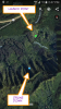
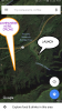
Now the interesting part of story, THE RECOVERY. I have a TRACKIMO, but wasn't attached. I used recorded flight data, gave me exact coordinates. 21.345607,-157.809895 (look it up ) In combination with trackimo, cell phone, iPad, laptop, Google maps, apps, I found it. While hiking to locate drone, I packed the trackimo with me, and the guys at house used my laptop to monitor my movement.
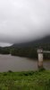
Story gets more interesting, lol. The p3 was 2,600 ft from launch site, in a remote mountain side in Hawaii. Took me 2 days in the jungle, with 2 hurricanes passing by. (Passed by) But rain off and on. First day, I had to give up because of day light running out, 2.5 hr hike out,and I was close (150 ft. According to map) but drone was on the next ridge of over. Almost stepped on pigs bedded down in thick *** ferns.
So...day 2: Went back but much earlier. Following my flagged trail. There was no obvious foot trails, just thick jungle, streams, lots of mud (very slippery ) and steep terrain. Crawling over and under thick vegatation. I climbed trees to get GPS signal sometimes. Stayed in one tree for a while waiting for rain to stop. At that point, I was very close. I honed in for the last time and decended from the knife ridge. There she is, upright, close to ground level. It's been rained on for 3 days. Packed it up, hiked out just in time for last light (again). Gruesome, gruesome adventure. Circuit boards probably need replacing. Not going to power up till inspected by pro. I'll post pics and vids later. Thanks for reading if you made it this far. Aloha
First, it was MY mistake. Was flying it backwards, camera facing me. About 270 ft altitude (not enough ). By the time I saw tree tops at camera height, well, you know what happens next. Happened pretty fast. No time to react. Down she goes.
Now the interesting part of story, THE RECOVERY. I have a TRACKIMO, but wasn't attached. I used recorded flight data, gave me exact coordinates. 21.345607,-157.809895 (look it up ) In combination with trackimo, cell phone, iPad, laptop, Google maps, apps, I found it. While hiking to locate drone, I packed the trackimo with me, and the guys at house used my laptop to monitor my movement.
Story gets more interesting, lol. The p3 was 2,600 ft from launch site, in a remote mountain side in Hawaii. Took me 2 days in the jungle, with 2 hurricanes passing by. (Passed by) But rain off and on. First day, I had to give up because of day light running out, 2.5 hr hike out,and I was close (150 ft. According to map) but drone was on the next ridge of over. Almost stepped on pigs bedded down in thick *** ferns.
So...day 2: Went back but much earlier. Following my flagged trail. There was no obvious foot trails, just thick jungle, streams, lots of mud (very slippery ) and steep terrain. Crawling over and under thick vegatation. I climbed trees to get GPS signal sometimes. Stayed in one tree for a while waiting for rain to stop. At that point, I was very close. I honed in for the last time and decended from the knife ridge. There she is, upright, close to ground level. It's been rained on for 3 days. Packed it up, hiked out just in time for last light (again). Gruesome, gruesome adventure. Circuit boards probably need replacing. Not going to power up till inspected by pro. I'll post pics and vids later. Thanks for reading if you made it this far. Aloha


")
")


