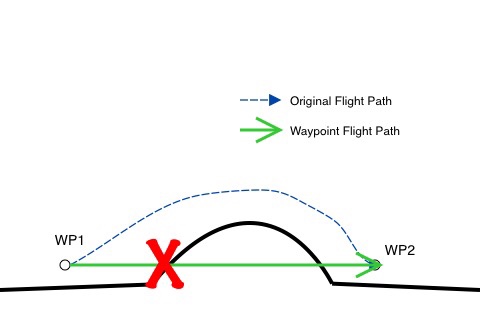
Be careful with Waypoints. Flight path between two waypoints is a straight line, even if you flew the original flight around or over obstacles (ie a hill).
Illustrated:

Illustrated:


Altitude variations are attained as it travels from point to point. The best option, as illustrated, would include 4 or more way points to make a smooth transition over the hill and back to the base altitude.Great point! Nice diagram to explain thank you.
I have yet to fly a way point mission.
So....
WP1 ( height 13M ) going to WP2 13M...reaching WP2 ( Height set for 30M ) bird reaches WP2 stops and goes to 30M, add a WP3 Bird goes from 30M reaches WP3 ( Height set for 13M )stops then Descends to 13M.
Sounds Square.... No Graduated climbs or descents to each WP.
Thanks for this info....hopefully u didn't find this out the hard way.
Altitude variations are attained as it travels from point to point. The best option, as illustrated, would include 4 or more way points to make a smooth transition over the hill and back to the base altitude.
Point A is 10 feetStair Stepping " Altitude variations are attained as it travels from point to point." That confused me Streve?
Did you mean ( Altitude variations are attained as it reaches point to point.? )
Point A is 10 feet
Point B is 20 feet
Half way to point be the altitude would be 15 ft... the variations in altitude for each point happen AS its flying to the next point, just like any plane would.
Not sure what you mean by "formula". In the original illustration I would set up 7 waypoints, if the hill was part of something I planned to record. one at the WP1, one at the start of the hills altitude change. One about half way up. Two more evenly spaced across the top. Another half way down, then another where the ground levels and the next transitioning away from the hill. If it were simply something in my way.. like a row of trees while inspecting a farm, I would simply pop up in altitude to clear them, and drop back to a working altitude after they were cleared. No need to make it smooth and pretty.Is that going against what the Op said?
Wait a min I see what your saying! Streve, if he had WP2 at the top of the arch then he needed a new WP3 at the bottom of the arch.
Is there a formula that should be followed as to an ascent and descent as far as spacing? or distance?
Have you tested this out yet III% Streve ....?Not sure what you mean by "formula". In the original illustration I would set up 7 waypoints, if the hill was part of something I planned to record. one at the WP1, one at the start of the hills altitude change. One about half way up. Two more evenly spaced across the top. Another half way down, then another where the ground levels and the next transitioning away from the hill. If it were simply something in my way.. like a row of trees while inspecting a farm, I would simply pop up in altitude to clear them, and drop back to a working altitude after they were cleared. No need to make it smooth and pretty.
In short -- Altitude changes require a waypoint as well, not just distance changes.
")
Sure.. that would work... IF its not important to smoothly follow the contour of the hill. You also run in to potentially close proximity to trees or whatever between WP1 and WP2, or WP2 and WP3
We use essential cookies to make this site work, and optional cookies to enhance your experience.


